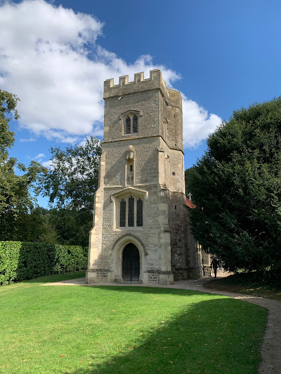
| Memorials | : | 0 |
| Location | : | Thame, South Oxfordshire District, England |
| Coordinate | : | 51.7433420, -1.0153490 |
| Description | : | The present farmhouse at Manor Farm consists of part of the east wing and kitchen offices of the old Manor House of North Weston. The remainder of the house was pulled down in the early 19th century. The medieval chapel lying to the west of the house was pulled down about 1810 or 1820. |
frequently asked questions (FAQ):
-
Where is North Weston Chapel?
North Weston Chapel is located at Thame, South Oxfordshire District ,Oxfordshire ,England.
-
North Weston Chapel cemetery's updated grave count on graveviews.com?
0 memorials
-
Where are the coordinates of the North Weston Chapel?
Latitude: 51.7433420
Longitude: -1.0153490
Nearby Cemetories:
1. Rycote Chapel
Great Haseley, South Oxfordshire District, England
Coordinate: 51.7366100, -1.0355370
2. St. Mary Magdalene Churchyard
Shabbington, Aylesbury Vale District, England
Coordinate: 51.7554420, -1.0357510
3. Saint Mary The Virgin Churchyard
Thame, South Oxfordshire District, England
Coordinate: 51.7511750, -0.9819190
4. St Helen Churchyard
Albury, South Oxfordshire District, England
Coordinate: 51.7406280, -1.0519520
5. Thame War Memorial
Thame, South Oxfordshire District, England
Coordinate: 51.7452570, -0.9743330
6. Baptist Chapel Burial Ground
Long Crendon, Aylesbury Vale District, England
Coordinate: 51.7730713, -0.9929426
7. Thame Park Chapel
Thame, South Oxfordshire District, England
Coordinate: 51.7290130, -0.9650540
8. St Giles Churchyard
Tetsworth, South Oxfordshire District, England
Coordinate: 51.7085800, -1.0086700
9. St. Nicholas' Churchyard
Ickford, Aylesbury Vale District, England
Coordinate: 51.7614648, -1.0656459
10. St Mary the Virgin Churchyard
Long Crendon, Aylesbury Vale District, England
Coordinate: 51.7758380, -0.9890670
11. Saint Leonard's Churchyard
Waterstock, South Oxfordshire District, England
Coordinate: 51.7451800, -1.0807500
12. St Mary's Churchyard
Waterperry, South Oxfordshire District, England
Coordinate: 51.7521000, -1.0894000
13. St Peter Churchyard
Great Haseley, South Oxfordshire District, England
Coordinate: 51.7102600, -1.0693200
14. St. Catherine Churchyard
Towersey, South Oxfordshire District, England
Coordinate: 51.7411700, -0.9360300
15. St Mary the Virgin Churchyard
Great Milton, South Oxfordshire District, England
Coordinate: 51.7170320, -1.0921100
16. St. Mary's Churchyard
Adwell, South Oxfordshire District, England
Coordinate: 51.6906560, -0.9938380
17. St. Mary Magdalene
Stoke Talmage, South Oxfordshire District, England
Coordinate: 51.6878240, -1.0183240
18. St. Andrew's Churchyard
Wheatfield, South Oxfordshire District, England
Coordinate: 51.6879720, -1.0050930
19. St. Mary's Churchyard
Chilton, Aylesbury Vale District, England
Coordinate: 51.7988760, -1.0055490
20. St Nicholas Churchyard
Chearsley, Aylesbury Vale District, England
Coordinate: 51.7868900, -0.9571600
21. St Mary's Churchyard
Sydenham, South Oxfordshire District, England
Coordinate: 51.7112360, -0.9398460
22. St Nicholas Churchyard
Kingsey, Aylesbury Vale District, England
Coordinate: 51.7545190, -0.9246110
23. St. Mary the Virgin Churchyard
Haddenham, Aylesbury Vale District, England
Coordinate: 51.7658180, -0.9266980
24. White Friar's Church
Oxford, City of Oxford, England
Coordinate: 51.7710000, -0.9288600

