
| Memorials | : | 0 |
| Location | : | Tetbury Upton, Cotswold District, England |
| Phone | : | 01666502367 |
| Website | : | www.stmichaelstetbury.org.uk/default.html |
| Coordinate | : | 51.6359632, -2.1585792 |
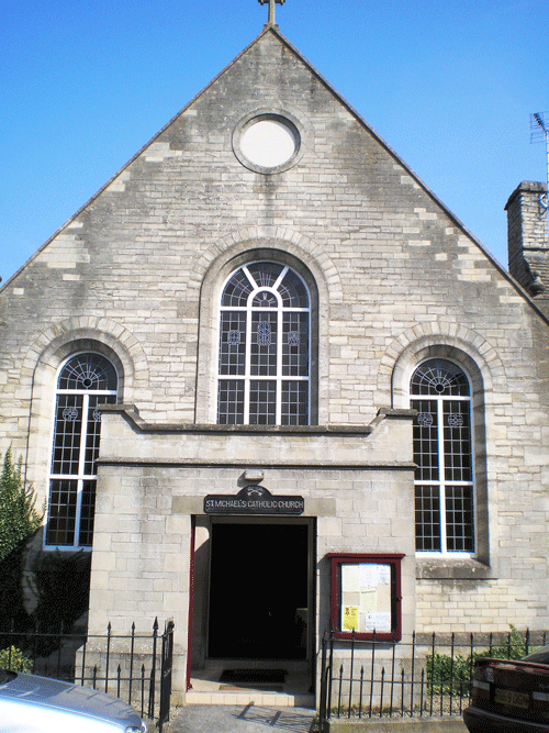
| Description | : | Early records of Catholicism in Tetbury are sketchy though a Catholic church stood on the spot now occupied by St Mary the Virgin, from very early on until the reformation. The original church fell into decay and was rebuilt in 1777 and the present building is the only Georgian church in the county. Tetbury is the oldest site of Christian worship in Gloucestershire âP] people have worshiped here since a monastery was founded in 681 and a minster church was mentioned but is not recorded anywhere else. It is assumed there was a church at Tetbury in 1086 as a priest... Read More |
frequently asked questions (FAQ):
-
Where is St. Michael's Churchyard?
St. Michael's Churchyard is located at Silver Street Tetbury Upton, Cotswold District ,Gloucestershire , GL8 8DHEngland.
-
St. Michael's Churchyard cemetery's updated grave count on graveviews.com?
0 memorials
-
Where are the coordinates of the St. Michael's Churchyard?
Latitude: 51.6359632
Longitude: -2.1585792

Nearby Cemetories:
1. St Mary the Virgin and St Mary Magdalen Church
Tetbury, Cotswold District, England
Coordinate: 51.6356080, -2.1598860
2. St Saviours Churchyard
Tetbury, Cotswold District, England
Coordinate: 51.6380160, -2.1630450
3. Holy Trinity Churchyard
Long Newnton, Cotswold District, England
Coordinate: 51.6308420, -2.1321200
4. St Mary the Virgin Churchyard
Beverston, Cotswold District, England
Coordinate: 51.6447450, -2.2013030
5. St John The Baptist Churchyard
Shipton Moyne, Cotswold District, England
Coordinate: 51.6052510, -2.1571120
6. St John the Baptist churchyard and extension
Brokenborough, Wiltshire Unitary Authority, England
Coordinate: 51.6022576, -2.1206102
7. Holy Cross Churchyard
Avening, Cotswold District, England
Coordinate: 51.6806190, -2.1755620
8. All Saints Churchyard
Crudwell, Wiltshire Unitary Authority, England
Coordinate: 51.6349050, -2.0644280
9. Leighterton Church Cemetery
Leighterton, Cotswold District, England
Coordinate: 51.6176900, -2.2518400
10. St Peter Churchyard
Rodmarton, Cotswold District, England
Coordinate: 51.6812230, -2.0841920
11. Minchinhampton Baptist Churchyard
Minchinhampton, Stroud District, England
Coordinate: 51.7039614, -2.1853756
12. St. John the Baptist Churchyard
Charlton (North), Wiltshire Unitary Authority, England
Coordinate: 51.5995500, -2.0604800
13. St. John the Baptist Churchyard
Kingscote, Cotswold District, England
Coordinate: 51.6644230, -2.2640480
14. Holy Trinity Churchyard
Minchinhampton, Stroud District, England
Coordinate: 51.7063600, -2.1860700
15. Holy Trinity Churchyard
Amberley, Stroud District, England
Coordinate: 51.7087660, -2.2177170
16. Amberley Church Cemetery
Amberley, Stroud District, England
Coordinate: 51.7091900, -2.2196100
17. Brimscombe Cemetery
Brimscombe, Stroud District, England
Coordinate: 51.7165900, -2.1900600
18. Priory Church of the Annunciation Churchyard
Woodchester, Stroud District, England
Coordinate: 51.7080680, -2.2305250
19. Amberley Methodist Church - Littleworth Wesleyan C
Amberley, Stroud District, England
Coordinate: 51.7123580, -2.2202540
20. Christ Church Churchyard
Chalford, Stroud District, England
Coordinate: 51.7214500, -2.1577900
21. St. Mary of the Angels Churchyard
Chalford, Stroud District, England
Coordinate: 51.7219000, -2.1708000
22. St Nicholas Churchyard
Ozleworth, Cotswold District, England
Coordinate: 51.6380070, -2.2986530
23. Chalford Baptist Tabernacle Churchyard
Chalford, Stroud District, England
Coordinate: 51.7226610, -2.1443260
24. All Saints Churchyard
Corston, Wiltshire Unitary Authority, England
Coordinate: 51.5543570, -2.1085990