
| Memorials | : | 2 |
| Location | : | Amberley, Stroud District, England |
| Coordinate | : | 51.7123580, -2.2202540 |
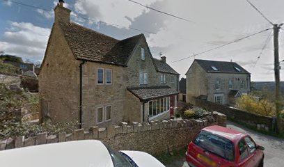
| Description | : | Situated in Marling Close, Amberley, Gloucestershire, the Littleworth Wesleyan Chapel was founded in 1790. Non-Conformist Chapels and Meeting Houses, Gloucestershire (1986) records this former Wesleyan Chapel as belonging to Minchinhampton, describing it as "built in 1790, but much altered and refitted in 1887. Three-bay front with two tiers of round-arched windows; four bay sides with two tiers of lancet windows, except where a later building adjoins. The interior is 34½ft by 32½ft, so almost square". The dedication plaque reads "Built 1790 / Littleworth / Wesleyan / Chapel / Renovated 1887". The return to the Religious Census of 1851 for the Wesleyan Chapel in Minchinhampton... Read More |
frequently asked questions (FAQ):
-
Where is Amberley Methodist Church - Littleworth Wesleyan C?
Amberley Methodist Church - Littleworth Wesleyan C is located at Marling Close Amberley, Stroud District ,Gloucestershire ,England.
-
Amberley Methodist Church - Littleworth Wesleyan C cemetery's updated grave count on graveviews.com?
2 memorials
-
Where are the coordinates of the Amberley Methodist Church - Littleworth Wesleyan C?
Latitude: 51.7123580
Longitude: -2.2202540
Nearby Cemetories:
1. Amberley Church Cemetery
Amberley, Stroud District, England
Coordinate: 51.7091900, -2.2196100
2. Holy Trinity Churchyard
Amberley, Stroud District, England
Coordinate: 51.7087660, -2.2177170
3. Priory Church of the Annunciation Churchyard
Woodchester, Stroud District, England
Coordinate: 51.7080680, -2.2305250
4. St Mary's Churchyard
Woodchester, Stroud District, England
Coordinate: 51.7224900, -2.2333920
5. Brimscombe Cemetery
Brimscombe, Stroud District, England
Coordinate: 51.7165900, -2.1900600
6. Holy Trinity Churchyard
Minchinhampton, Stroud District, England
Coordinate: 51.7063600, -2.1860700
7. Rodborough Tabernacle
Rodborough, Stroud District, England
Coordinate: 51.7345300, -2.2245700
8. Stroud Old Cemetery
Stroud, Stroud District, England
Coordinate: 51.7337658, -2.2094599
9. Minchinhampton Baptist Churchyard
Minchinhampton, Stroud District, England
Coordinate: 51.7039614, -2.1853756
10. St. Mary Magdalene Churchyard
Rodborough, Stroud District, England
Coordinate: 51.7384180, -2.2284060
11. All Saints Churchyard
Selsley, Stroud District, England
Coordinate: 51.7327800, -2.2487900
12. Kings Stanley Baptist Cemetery
Kings Stanley, Stroud District, England
Coordinate: 51.7269460, -2.2621780
13. Stroud Hill Cemetery
Stroud, Stroud District, England
Coordinate: 51.7415670, -2.2002660
14. St. Mary of the Angels Churchyard
Chalford, Stroud District, England
Coordinate: 51.7219000, -2.1708000
15. St. Laurence Churchyard
Stroud, Stroud District, England
Coordinate: 51.7459470, -2.2153950
16. Saint Matthews Churchyard
Cainscross, Stroud District, England
Coordinate: 51.7430640, -2.2469780
17. St. Michael's and All Angels Churchyard
Bisley, Stroud District, England
Coordinate: 51.7301150, -2.1715900
18. Christ Church Churchyard
Chalford, Stroud District, England
Coordinate: 51.7214500, -2.1577900
19. St George's Churchyard
Kings Stanley, Stroud District, England
Coordinate: 51.7352650, -2.2765210
20. Holy Cross Churchyard
Avening, Cotswold District, England
Coordinate: 51.6806190, -2.1755620
21. Eastcombe Baptist Churchyard
Eastcombe, Stroud District, England
Coordinate: 51.7378009, -2.1606789
22. France Lynch Congregational Chapelyard
Chalford, Stroud District, England
Coordinate: 51.7251000, -2.1485300
23. St Paul Churchyard
Whiteshill, Stroud District, England
Coordinate: 51.7597750, -2.2321540
24. Chalford Baptist Tabernacle Churchyard
Chalford, Stroud District, England
Coordinate: 51.7226610, -2.1443260