
| Memorials | : | 1 |
| Location | : | Foxholes, Ryedale District, England |
| Coordinate | : | 54.1297000, -0.4843000 |
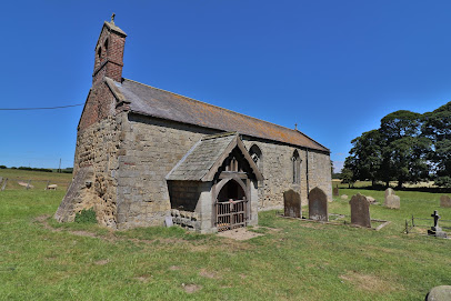
| Description | : | Fourteenth Century Grade: II Church incorporating twelfth century fabric at west end; late eighteenth century bellcote; porch added during restoration of 1882. Restoration by G Fowler Jones. Monument: early C14 effigy, Robert FitzRalph, Lord Grimthorpe and Greystock (d1317). |
frequently asked questions (FAQ):
-
Where is St Nicholas Churchyard?
St Nicholas Churchyard is located at Foxholes Butterwick Foxholes, Ryedale District ,North Yorkshire , YO17 8HFEngland.
-
St Nicholas Churchyard cemetery's updated grave count on graveviews.com?
1 memorials
-
Where are the coordinates of the St Nicholas Churchyard?
Latitude: 54.1297000
Longitude: -0.4843000
Nearby Cemetories:
1. St Andrew Churchyard
Weaverthorpe, Ryedale District, England
Coordinate: 54.1267400, -0.5226800
2. Octon Crematorium
Langtoft, East Riding of Yorkshire Unitary Authority, England
Coordinate: 54.1089720, -0.4506760
3. St Nicholas Churchyard
Ganton, Ryedale District, England
Coordinate: 54.1846000, -0.4846000
4. St. Mary Churchyard
Cowlam, East Riding of Yorkshire Unitary Authority, England
Coordinate: 54.0787700, -0.5292200
5. St. Mary's Church Luttons Ambo
West Lutton, Ryedale District, England
Coordinate: 54.1105340, -0.5779463
6. Cottam Church
Cottam, East Riding of Yorkshire Unitary Authority, England
Coordinate: 54.0707320, -0.4833770
7. St. Hilda Churchyard
Sherburn, Ryedale District, England
Coordinate: 54.1837400, -0.5311200
8. Fordon Churchyard
East Riding of Yorkshire Unitary Authority, England
Coordinate: 54.1610140, -0.3939100
9. St. Peter's Churchyard
Willerby, Ryedale District, England
Coordinate: 54.1984200, -0.4558500
10. St. Andrew's Churchyard
East Heslerton, Ryedale District, England
Coordinate: 54.1772500, -0.5825000
11. All Saints Churchyard
West Heslerton, Ryedale District, England
Coordinate: 54.1704100, -0.6057100
12. St Cuthbert Churchyard
Burton Fleming, East Riding of Yorkshire Unitary Authority, England
Coordinate: 54.1357420, -0.3431860
13. St. Andrew's Churchyard
Kirby Grindalythe, Ryedale District, England
Coordinate: 54.0955440, -0.6200050
14. Flixton Cemetery New
Folkton, Scarborough Borough, England
Coordinate: 54.2006600, -0.3934700
15. Kilham Cemetery
Kilham, East Riding of Yorkshire Unitary Authority, England
Coordinate: 54.0687100, -0.3690310
16. All Saints Churchyard
Kilham, East Riding of Yorkshire Unitary Authority, England
Coordinate: 54.0645570, -0.3750570
17. St John The Evangelist Churchyard
Folkton, Scarborough Borough, England
Coordinate: 54.2020400, -0.3865200
18. St Peter Churchyard
Wintringham, Ryedale District, England
Coordinate: 54.1467660, -0.6431680
19. All Saints Church Cemetery
Brompton-by-Sawdon, Scarborough Borough, England
Coordinate: 54.2223100, -0.5500900
20. All Saints Churchyard
Brompton-by-Sawdon, Scarborough Borough, England
Coordinate: 54.2262550, -0.5549320
21. God's Acre Cemetery
Hunmanby, Scarborough Borough, England
Coordinate: 54.1742830, -0.3167530
22. All Saints Churchyard
Hunmanby, Scarborough Borough, England
Coordinate: 54.1813770, -0.3219840
23. St Martin Churchyard
Seamer, Scarborough Borough, England
Coordinate: 54.2361500, -0.4437100
24. St. Helen’s & All Saints Churchyard
Wykeham, Scarborough Borough, England
Coordinate: 54.2372000, -0.5212000