
| Memorials | : | 0 |
| Location | : | Cowlam, East Riding of Yorkshire Unitary Authority, England |
| Coordinate | : | 54.0787700, -0.5292200 |
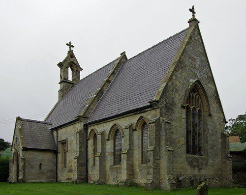
| Description | : | The church isn’t easy to find unless you have the 1:50,000 Ordnance Survey Map Sheet 101. The grid reference is SE966655. The nearest post code is YO25 3AE. Taking the B1253, travelling north east of Sledmere, at the first cross roads after about two miles, turn right. The road is signed to Cowlam. The church is set at the back of the farmyard by the first group of buildings on your left. Take the second turn into the buildings which has a small sign to the church. There is plenty of parking by the church. If the church is locked,... Read More |
frequently asked questions (FAQ):
-
Where is St. Mary Churchyard?
St. Mary Churchyard is located at Cowlam, East Riding of Yorkshire Unitary Authority ,East Riding of Yorkshire , YO25 3AEEngland.
-
St. Mary Churchyard cemetery's updated grave count on graveviews.com?
0 memorials
-
Where are the coordinates of the St. Mary Churchyard?
Latitude: 54.0787700
Longitude: -0.5292200
Nearby Cemetories:
1. Cottam Church
Cottam, East Riding of Yorkshire Unitary Authority, England
Coordinate: 54.0707320, -0.4833770
2. St. Mary's Church Luttons Ambo
West Lutton, Ryedale District, England
Coordinate: 54.1105340, -0.5779463
3. St Andrew Churchyard
Weaverthorpe, Ryedale District, England
Coordinate: 54.1267400, -0.5226800
4. Octon Crematorium
Langtoft, East Riding of Yorkshire Unitary Authority, England
Coordinate: 54.1089720, -0.4506760
5. St. Andrew's Churchyard
Kirby Grindalythe, Ryedale District, England
Coordinate: 54.0955440, -0.6200050
6. St Nicholas Churchyard
Foxholes, Ryedale District, England
Coordinate: 54.1297000, -0.4843000
7. St. Michael and All Angels Churchyard
Garton-on-the-Wolds, East Riding of Yorkshire Unitary Authority, England
Coordinate: 54.0204960, -0.5030440
8. St. Mary's Churchyard
Fimber, East Riding of Yorkshire Unitary Authority, England
Coordinate: 54.0337830, -0.6361950
9. All Saints Churchyard
Driffield, East Riding of Yorkshire Unitary Authority, England
Coordinate: 54.0077480, -0.4419340
10. St. Mary's Churchyard
Wharram le Street, Ryedale District, England
Coordinate: 54.0820040, -0.6810779
11. Driffield Cemetery
Driffield, East Riding of Yorkshire Unitary Authority, England
Coordinate: 54.0112620, -0.4254680
12. All Saints Churchyard
Kilham, East Riding of Yorkshire Unitary Authority, England
Coordinate: 54.0645570, -0.3750570
13. Kilham Cemetery
Kilham, East Riding of Yorkshire Unitary Authority, England
Coordinate: 54.0687100, -0.3690310
14. St. Martin Churchyard
Wharram Percy, Ryedale District, England
Coordinate: 54.0665700, -0.6901300
15. St Peter Churchyard
Wintringham, Ryedale District, England
Coordinate: 54.1467660, -0.6431680
16. St Mary Churchyard
Kirkburn, East Riding of Yorkshire Unitary Authority, England
Coordinate: 53.9820470, -0.5073770
17. St. Mary's Churchyard
Fridaythorpe, East Riding of Yorkshire Unitary Authority, England
Coordinate: 54.0220090, -0.6667190
18. All Saints Churchyard
West Heslerton, Ryedale District, England
Coordinate: 54.1704100, -0.6057100
19. St. Andrew's Churchyard
East Heslerton, Ryedale District, England
Coordinate: 54.1772500, -0.5825000
20. St. Hilda Churchyard
Sherburn, Ryedale District, England
Coordinate: 54.1837400, -0.5311200
21. St Nicholas Churchyard
Ganton, Ryedale District, England
Coordinate: 54.1846000, -0.4846000
22. St. Nicholas Churchyard
North Grimston, Ryedale District, England
Coordinate: 54.0989220, -0.7148680
23. St. Martin's Churchyard
Lowthorpe, East Riding of Yorkshire Unitary Authority, England
Coordinate: 54.0318880, -0.3537900
24. Fordon Churchyard
East Riding of Yorkshire Unitary Authority, England
Coordinate: 54.1610140, -0.3939100