
| Memorials | : | 1 |
| Location | : | Broughton, Stafford Borough, England |
| Coordinate | : | 52.9003430, -2.3491340 |
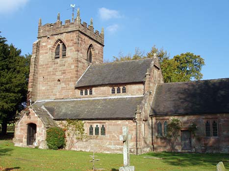
| Description | : | Grid Ref: SJ 765 337 St. Peter's at Broughton was built by Thomas Broughton in 1630-34 as a chapel for Broughton Hall, which was being restored and extended at that time. It was built on the site of an earlier chapel.The church is in the Gothic style and its original 17th century box pews remain intact.There two aisles have two-bay.The chancel contains stained glass windows brought from the Low Countries by the Delves and Broughton families.There is a window of heraldic devices in the north wall of the chancel.The South window shows Sir John Delves,killed at the Battle of Tewkesbury... Read More |
frequently asked questions (FAQ):
-
Where is St Peter Churchyard?
St Peter Churchyard is located at Broughton, Stafford Borough ,Staffordshire ,England.
-
St Peter Churchyard cemetery's updated grave count on graveviews.com?
1 memorials
-
Where are the coordinates of the St Peter Churchyard?
Latitude: 52.9003430
Longitude: -2.3491340
Nearby Cemetories:
1. St John the Baptist Churchyard
Ashley, Newcastle-Under-Lyme Borough, England
Coordinate: 52.9247740, -2.3541570
2. St. Mary's Churchyard
Hales, Shropshire Unitary Authority, England
Coordinate: 52.9024580, -2.4274470
3. St Peter Churchyard
Maer, Newcastle-Under-Lyme Borough, England
Coordinate: 52.9419660, -2.3099140
4. Saint Mary Church
Mucklestone, Newcastle-Under-Lyme Borough, England
Coordinate: 52.9328620, -2.4098060
5. All Saints Churchyard
Standon, Stafford Borough, England
Coordinate: 52.9119000, -2.2699000
6. St Michael and All Angels Churchyard
Adbaston, Stafford Borough, England
Coordinate: 52.8482630, -2.3545010
7. St. Swithun's Churchyard
Cheswardine, Shropshire Unitary Authority, England
Coordinate: 52.8660400, -2.4187700
8. St. Chad's Church, Slindon, Staffordshire
Stafford Borough, England
Coordinate: 52.8870960, -2.2579986
9. Holy Trinity Churchyard
Eccleshall, Stafford Borough, England
Coordinate: 52.8596600, -2.2575600
10. St Mary and All Saints Churchyard
Whitmore, Newcastle-Under-Lyme Borough, England
Coordinate: 52.9663190, -2.2838270
11. Madeley Cemetery
Madeley, Newcastle-Under-Lyme Borough, England
Coordinate: 52.9878150, -2.3395660
12. St Oswald's Church Burial Ground
Hinstock, Shropshire Unitary Authority, England
Coordinate: 52.8346100, -2.4577700
13. St Mary Churchyard
Ellenhall, Stafford Borough, England
Coordinate: 52.8360140, -2.2372270
14. Church of St Peter
Norbury, Stafford Borough, England
Coordinate: 52.8084000, -2.3184000
15. All Saints Churchyard
Chebsey, Stafford Borough, England
Coordinate: 52.8546150, -2.2098560
16. All Saints Churchyard
Madeley, Newcastle-Under-Lyme Borough, England
Coordinate: 52.9962463, -2.3400240
17. St Luke Churchyard
Tittensor, Stafford Borough, England
Coordinate: 52.9407830, -2.1889820
18. Ronton Priory
Ellenhall, Stafford Borough, England
Coordinate: 52.8157600, -2.2414900
19. St Peter Churchyard
Adderley, Shropshire Unitary Authority, England
Coordinate: 52.9517090, -2.5061580
20. St John the Baptist Churchyard
Keele, Newcastle-Under-Lyme Borough, England
Coordinate: 53.0039410, -2.2848720
21. Trentham Cemetery
Trentham, Stoke-on-Trent Unitary Authority, England
Coordinate: 52.9665640, -2.1980300
22. Chetwynd Churchyard
Newport, Telford and Wrekin Unitary Authority, England
Coordinate: 52.7905280, -2.3916390
23. Forton All Saints Churchyard
Newport, Telford and Wrekin Unitary Authority, England
Coordinate: 52.7876210, -2.3640430
24. Saint Michael and All Angels
Chetwynd, Telford and Wrekin Unitary Authority, England
Coordinate: 52.7887300, -2.3935160