
| Memorials | : | 0 |
| Location | : | Ellenhall, Stafford Borough, England |
| Website | : | our-benefice.com/st-marys-ellenhall/ |
| Coordinate | : | 52.8360140, -2.2372270 |
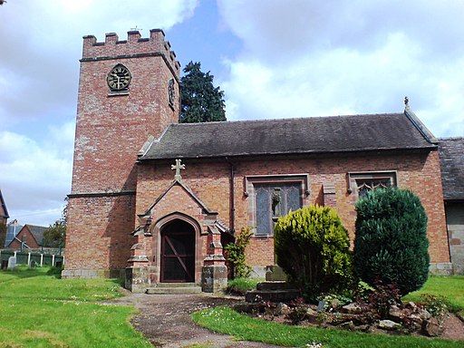
| Description | : | The village church of St Mary stands on a natural mound close to the highest point at the northern end of the village. The grey sandstone chancel is the oldest part of the church dating from the 12th century, while the red-brick nave and tower represent a 1757 re-build of an earlier structure. It is a Grade II listed building |
frequently asked questions (FAQ):
-
Where is St Mary Churchyard?
St Mary Churchyard is located at Ellenhall, Stafford Borough ,Staffordshire ,England.
-
St Mary Churchyard cemetery's updated grave count on graveviews.com?
0 memorials
-
Where are the coordinates of the St Mary Churchyard?
Latitude: 52.8360140
Longitude: -2.2372270
Nearby Cemetories:
1. Ronton Priory
Ellenhall, Stafford Borough, England
Coordinate: 52.8157600, -2.2414900
2. Ranton All Saints
Ranton, Stafford Borough, England
Coordinate: 52.8151300, -2.2156400
3. All Saints Churchyard
Chebsey, Stafford Borough, England
Coordinate: 52.8546150, -2.2098560
4. Holy Trinity Churchyard
Eccleshall, Stafford Borough, England
Coordinate: 52.8596600, -2.2575600
5. St. Lawrence Churchyard
Gnosall, Stafford Borough, England
Coordinate: 52.7853010, -2.2533270
6. St. Chad's Church, Slindon, Staffordshire
Stafford Borough, England
Coordinate: 52.8870960, -2.2579986
7. Church of St Peter
Norbury, Stafford Borough, England
Coordinate: 52.8084000, -2.3184000
8. St Giles Churchyard
Haughton, Stafford Borough, England
Coordinate: 52.7817750, -2.2005140
9. Eccleshall Road Cemetery
Stafford, Stafford Borough, England
Coordinate: 52.8158760, -2.1252976
10. St Michael and All Angels Churchyard
Adbaston, Stafford Borough, England
Coordinate: 52.8482630, -2.3545010
11. Stafford Prison Cemetery
Stafford, Stafford Borough, England
Coordinate: 52.8122341, -2.1166098
12. St. Mary's Churchyard
Stafford, Stafford Borough, England
Coordinate: 52.8057000, -2.1187000
13. All Saints Churchyard
Standon, Stafford Borough, England
Coordinate: 52.9119000, -2.2699000
14. St Chad
Stafford, Stafford Borough, England
Coordinate: 52.8061611, -2.1165797
15. Stone Cemetery
Stone, Stafford Borough, England
Coordinate: 52.8874860, -2.1369430
16. St. Editha's Parish Church Graveyard
Church Eaton, Stafford Borough, England
Coordinate: 52.7560690, -2.2259540
17. St Saviour Churchyard
Aston-by-Stone, Stafford Borough, England
Coordinate: 52.8841410, -2.1283140
18. St Mary and All Saints
Bradley, Stafford Borough, England
Coordinate: 52.7599257, -2.1808769
19. Stone Priory
Stone, Stafford Borough, England
Coordinate: 52.9013610, -2.1441120
20. St. Michael and St. Wulfad Churchyard
Stone, Stafford Borough, England
Coordinate: 52.9016030, -2.1433420
21. Christ Church Churchyard
Stone, Stafford Borough, England
Coordinate: 52.9042670, -2.1477510
22. Forton All Saints Churchyard
Newport, Telford and Wrekin Unitary Authority, England
Coordinate: 52.7876210, -2.3640430
23. St Mary's, Moreton
Moreton, Stafford Borough, England
Coordinate: 52.7521490, -2.3021420
24. St Peter Churchyard
Broughton, Stafford Borough, England
Coordinate: 52.9003430, -2.3491340