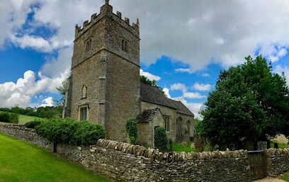
| Memorials | : | 0 |
| Location | : | Little Rollright, West Oxfordshire District, England |
| Phone | : | 44 1608 642688 |
| Coordinate | : | 51.9688330, -1.5742230 |
| Description | : | This isolated chuch sits on a arise in the midst of a farm tucked in the tiny valley bottom. There is a minor road from Moreton-in-March to Great Rollright and about a mile outside of Great Rollright, a lane leads off to the southeast. Leading through the farmto the church is a permissive road. The earliest parts of St. Philips is 13th century and includes the chancel arch and buttresses. The nave was rebuilt in the 16th centery and the south porch, doorway and five-light window on the south side of the nave maybe of the same date.... Read More |
frequently asked questions (FAQ):
-
Where is St. Philip Church?
St. Philip Church is located at Little Rollright, West Oxfordshire District ,Oxfordshire , OX7 5QAEngland.
-
St. Philip Church cemetery's updated grave count on graveviews.com?
0 memorials
-
Where are the coordinates of the St. Philip Church?
Latitude: 51.9688330
Longitude: -1.5742230
Nearby Cemetories:
1. St. Mary's Churchyard
Salford, West Oxfordshire District, England
Coordinate: 51.9505810, -1.5844700
2. Saint Peter and St Paul Churchyard
Long Compton, Stratford-on-Avon District, England
Coordinate: 51.9949740, -1.5823690
3. Chipping Norton Cemetery
Chipping Norton, West Oxfordshire District, England
Coordinate: 51.9414200, -1.5555900
4. St. Mary the Virgin Churchyard
Chipping Norton, West Oxfordshire District, England
Coordinate: 51.9434900, -1.5476200
5. Friends Burial Ground
Chipping Norton, West Oxfordshire District, England
Coordinate: 51.9415950, -1.5498310
6. Great Rollright St Andrews Churchyard
Rollright, West Oxfordshire District, England
Coordinate: 51.9809290, -1.5255550
7. Holy Trinity Catholic Churchyard
Chipping Norton, West Oxfordshire District, England
Coordinate: 51.9439300, -1.5388200
8. St Peter's Church
Cornwell, West Oxfordshire District, England
Coordinate: 51.9418660, -1.6062440
9. St Lawrence's Church
Barton-on-the-Heath, Stratford-on-Avon District, England
Coordinate: 51.9918300, -1.6272375
10. St. Mary the Virgin Churchyard
Chastleton, West Oxfordshire District, England
Coordinate: 51.9595360, -1.6395330
11. St. Michael's
Whichford, Stratford-on-Avon District, England
Coordinate: 52.0094910, -1.5467784
12. All Saints Churchyard
Churchill, West Oxfordshire District, England
Coordinate: 51.9146590, -1.5898010
13. St Michael and All Angels Church
Great Wolford, Stratford-on-Avon District, England
Coordinate: 52.0091000, -1.6367450
14. Old St. Nicholas Churchyard
Heythrop, West Oxfordshire District, England
Coordinate: 51.9468000, -1.4889600
15. Saint John The Baptist Churchyard
Cherington, Stratford-on-Avon District, England
Coordinate: 52.0271460, -1.5762520
16. St Peter Churchyard
Daylesford, Cotswold District, England
Coordinate: 51.9310080, -1.6479680
17. Hook Norton Baptist Burial Ground
Hook Norton, Cherwell District, England
Coordinate: 51.9953000, -1.4860900
18. St Peters Churchyard
Hook Norton, Cherwell District, England
Coordinate: 51.9954200, -1.4842490
19. Stourton Wesleyan Chapel Burial Ground
Stourton, Stratford-on-Avon District, England
Coordinate: 52.0303940, -1.5704780
20. St James' Church
Sarsden, West Oxfordshire District, England
Coordinate: 51.9048470, -1.5806760
21. Hook Norton Cemetery
Hook Norton, Cherwell District, England
Coordinate: 51.9969440, -1.4787690
22. St Andrew's Churchyard
Kingham, West Oxfordshire District, England
Coordinate: 51.9113760, -1.6255990
23. St. Thomas Becket Cemetery
Sutton-under-Brailes, Stratford-on-Avon District, England
Coordinate: 52.0342400, -1.5657800
24. St Nicholas Churchyard
Oddington, Cotswold District, England
Coordinate: 51.9278340, -1.6597080

