
| Memorials | : | 0 |
| Location | : | Dottery, West Dorset District, England |
| Coordinate | : | 50.7536000, -2.7694000 |
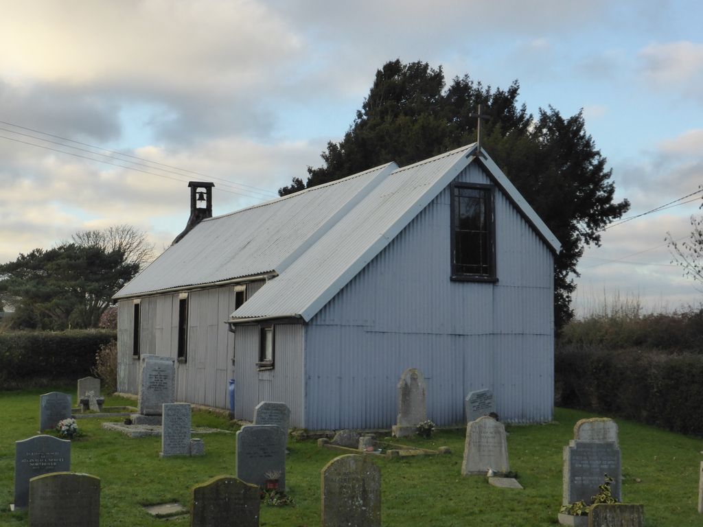
| Description | : | Founded in 1881, St Saviour’s at Dottery, near Bridport, is the only ‘Tin Tabernacle’ in Dorset in which regular services are still held. While it is part of the Loders parish, it is separated from the main part of Loders parish and is actually nearer to Bridport. It is now run as part of the United Benefice of Askerswell, Loders, Powerstock and Symondsbury. The earliest grave seems to be 1915 and the earliest date of birth, based on age, would be 1846. |
frequently asked questions (FAQ):
-
Where is St Saviour's Churchyard?
St Saviour's Churchyard is located at Dottery, West Dorset District ,Dorset , DT6 5PSEngland.
-
St Saviour's Churchyard cemetery's updated grave count on graveviews.com?
0 memorials
-
Where are the coordinates of the St Saviour's Churchyard?
Latitude: 50.7536000
Longitude: -2.7694000
Nearby Cemetories:
1. St Swithun Churchyard
Allington, West Dorset District, England
Coordinate: 50.7349230, -2.7642530
2. Holy Trinity Churchyard
Bradpole, West Dorset District, England
Coordinate: 50.7458520, -2.7378410
3. St. Mary's Churchyard
Bridport, West Dorset District, England
Coordinate: 50.7305630, -2.7580380
4. Quaker Burial Ground
Bridport, West Dorset District, England
Coordinate: 50.7285000, -2.7577000
5. Bridport Cemetery
Bridport, West Dorset District, England
Coordinate: 50.7335280, -2.7423070
6. St Mary Magdalene Churchyard
Loders, West Dorset District, England
Coordinate: 50.7458420, -2.7226110
7. St Peter Churchyard
Eype, West Dorset District, England
Coordinate: 50.7233600, -2.7794800
8. Christ's Churchyard
Melplash, West Dorset District, England
Coordinate: 50.7751300, -2.7324000
9. Old Church Cemetery
Bothenhampton, West Dorset District, England
Coordinate: 50.7230130, -2.7449430
10. Chideock Manor
Chideock, West Dorset District, England
Coordinate: 50.7377620, -2.8229350
11. St Michaels Cemetery
Melplash, West Dorset District, England
Coordinate: 50.7832180, -2.7306110
12. St. Giles Churchyard
Chideock, West Dorset District, England
Coordinate: 50.7325000, -2.8211000
13. St Mary Churchyard
Netherbury, West Dorset District, England
Coordinate: 50.7922890, -2.7529110
14. Parnham House
Beaminster, West Dorset District, England
Coordinate: 50.7995080, -2.7418580
15. Stanton St. Gabriel Churchyard
Morcombelake, West Dorset District, England
Coordinate: 50.7407480, -2.8443460
16. St. Mary the Virgin Churchyard
Powerstock, West Dorset District, England
Coordinate: 50.7632920, -2.6863210
17. St Mary Churchyard
Pilsdon, West Dorset District, England
Coordinate: 50.7925420, -2.8317720
18. All Saints Churchyard
Mapperton, West Dorset District, England
Coordinate: 50.7943046, -2.7060315
19. St Mary of the Annunciation Churchyard
Beaminster, West Dorset District, England
Coordinate: 50.8085130, -2.7409170
20. St Mary Churchyard
Burton Bradstock, West Dorset District, England
Coordinate: 50.7028730, -2.7254190
21. Holy Trinity Churchyard
Beaminster, West Dorset District, England
Coordinate: 50.8125230, -2.7376500
22. St. Michael and All Angels Churchyard
Askerswell, West Dorset District, England
Coordinate: 50.7309450, -2.6675050
23. St Stephen Churchyard
Bettiscombe, West Dorset District, England
Coordinate: 50.7962210, -2.8540230
24. St John the Baptist Churchyard
Broadwindsor, West Dorset District, England
Coordinate: 50.8205790, -2.7996230