
| Memorials | : | 0 |
| Location | : | Porlock, West Somerset District, England |
| Coordinate | : | 51.1796510, -3.6060674 |
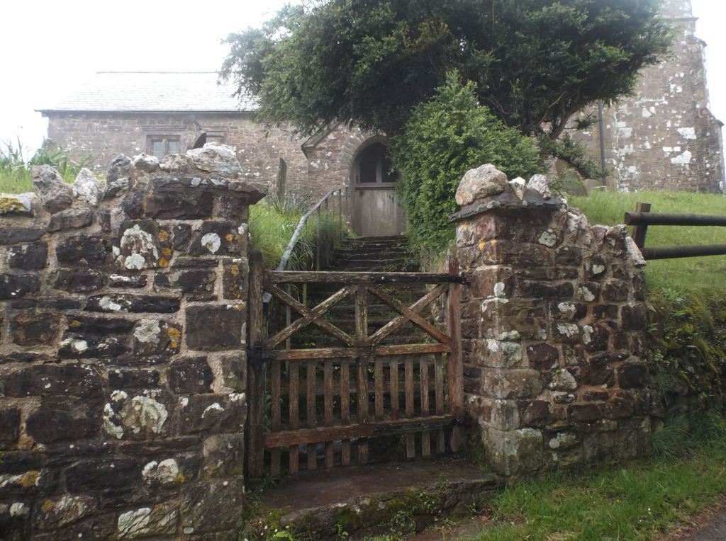
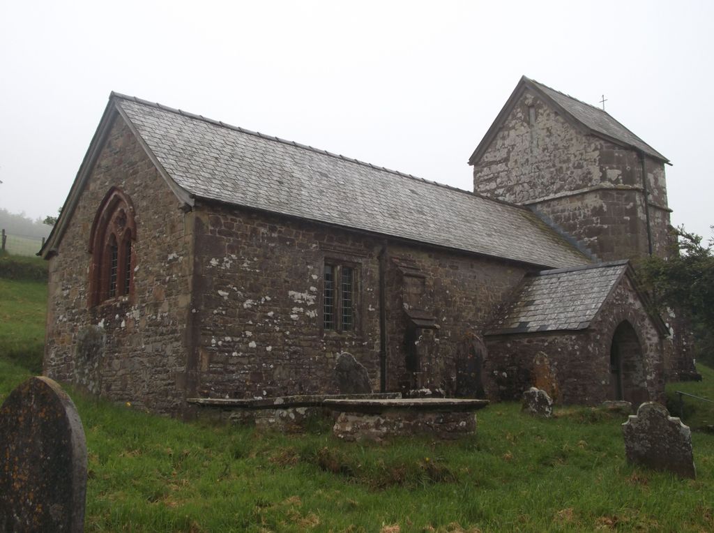
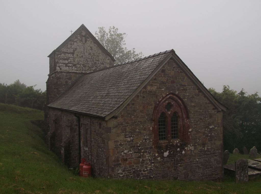
| Description | : | Stoke Pero Church is a Grade 2 listed building. It is claimed to be at a higher altitude than any other Church in England, at 1013 feet aabove sea level, it's certainly the highest on Exmoor, and isolated It doesn't have a known dedication but one of it's three bells is inscribed with Saint Barbara. The tower dates from the 13th century, but the rest of the Church was rebuilt in 1897 by Sir Thomas Dyke Acland, 12th Baronet, the stone building has a slate roof, three bay nave, chancel with a porch, the tower is supported by diagonal buttresses and has... Read More |
frequently asked questions (FAQ):
-
Where is Stoke Pero Churchyard?
Stoke Pero Churchyard is located at Stoke Pero Porlock, West Somerset District ,Somerset ,England.
-
Stoke Pero Churchyard cemetery's updated grave count on graveviews.com?
0 memorials
-
Where are the coordinates of the Stoke Pero Churchyard?
Latitude: 51.1796510
Longitude: -3.6060674
Nearby Cemetories:
1. Porlock Cemetery
Porlock, West Somerset District, England
Coordinate: 51.2033790, -3.5954070
2. St Dubricius Churchyard
Porlock, West Somerset District, England
Coordinate: 51.2083000, -3.5955000
3. Luccombe Extension Cemetery
Luccombe, West Somerset District, England
Coordinate: 51.1897360, -3.5609100
4. St. Mary's Churchyard
Luccombe, West Somerset District, England
Coordinate: 51.1895770, -3.5596880
5. Selworthy Extension Cemeteries
Selworthy, West Somerset District, England
Coordinate: 51.2098330, -3.5481240
6. All Saints Churchyard
Selworthy, West Somerset District, England
Coordinate: 51.2101800, -3.5475440
7. St. Mary Magdalene Churchyard
Exford, West Somerset District, England
Coordinate: 51.1341450, -3.6342160
8. Culbone St. Bueno's Churchyard
Oare, West Somerset District, England
Coordinate: 51.2213640, -3.6594820
9. All Saints Churchyard
Wootton Courtenay, West Somerset District, England
Coordinate: 51.1801840, -3.5203550
10. St. John the Evangelist Churchyard
Cutcombe, West Somerset District, England
Coordinate: 51.1424576, -3.5295319
11. St. Petrock's Churchyard
Timberscombe, West Somerset District, England
Coordinate: 51.1680950, -3.4948210
12. Minehead Cemetery
Minehead, West Somerset District, England
Coordinate: 51.2050650, -3.4982030
13. St. Mary the Virgin Churchyard
Oare, West Somerset District, England
Coordinate: 51.2124350, -3.7164290
14. Saint Andrew's Churchyard
Withypool, West Somerset District, England
Coordinate: 51.1078060, -3.6492700
15. Winsford Churchyard
Winsford, West Somerset District, England
Coordinate: 51.1038000, -3.5665000
16. St. Michael's Anglican Church Cemetery
Minehead, West Somerset District, England
Coordinate: 51.2110390, -3.4808250
17. St Peter's Church Exton
Exton, West Somerset District, England
Coordinate: 51.0925840, -3.5352300
18. Grabbist Hill Cemetery
Dunster, West Somerset District, England
Coordinate: 51.1820510, -3.4492540
19. Blesssed Virgin Mary Churchyard
Luxborough, West Somerset District, England
Coordinate: 51.1321490, -3.4680500
20. George Street Cemetery
Dunster, West Somerset District, England
Coordinate: 51.1833740, -3.4483046
21. St.Luke's Churchyard
Simonsbath, West Somerset District, England
Coordinate: 51.1408600, -3.7514560
22. Priory Churchyard of St. George
Dunster, West Somerset District, England
Coordinate: 51.1832000, -3.4459000
23. St Giles Churchyard
Hawkridge, West Somerset District, England
Coordinate: 51.0638000, -3.6266000
24. Saint John the Baptist Churchyard
Carhampton, West Somerset District, England
Coordinate: 51.1746000, -3.4186000