
| Memorials | : | 0 |
| Location | : | Thundridge, East Hertfordshire District, England |
| Coordinate | : | 51.8378330, -0.0156530 |
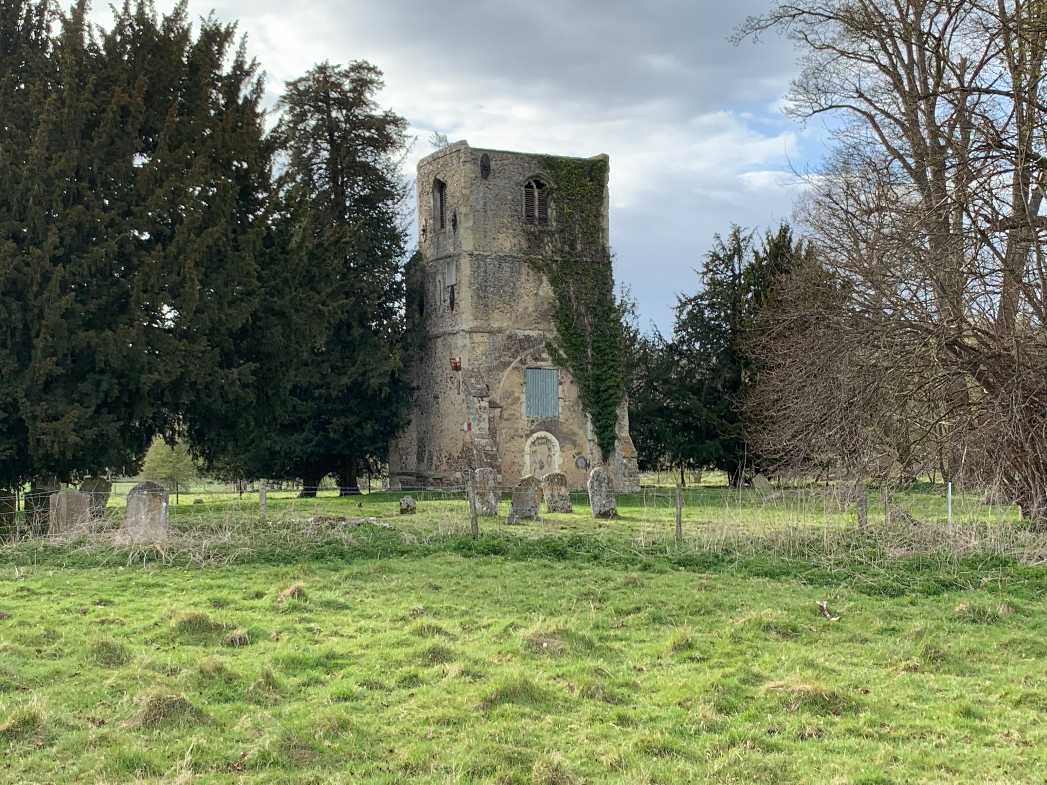
| Description | : | The old church of Thundridge, situated in the valley, near the river Rib, about half a mile from the North Road, was demolished - with the exception of the tower in 1853, and a great part of the material was used in the restoration of Sacomb Church. It was one of the oldest churches in this part of the county, and the low, semi-circular arch which connected with the nave, is enriched with a magnificent example of Norman moulding, which indicates the period of its building to have been about the year 1100. Also nearby is the Victorian Thundridge St... Read More |
frequently asked questions (FAQ):
-
Where is Thundridge Old Churchyard?
Thundridge Old Churchyard is located at Old Church Lane Thundridge, East Hertfordshire District ,Hertfordshire ,England.
-
Thundridge Old Churchyard cemetery's updated grave count on graveviews.com?
0 memorials
-
Where are the coordinates of the Thundridge Old Churchyard?
Latitude: 51.8378330
Longitude: -0.0156530
Nearby Cemetories:
1. St. Mary Parish Churchyard
Thundridge, East Hertfordshire District, England
Coordinate: 51.8366590, -0.0291820
2. St John the Evangelist Churchyard
High Cross, East Hertfordshire District, England
Coordinate: 51.8500010, -0.0213550
3. Ware Cemetery New
Ware, East Hertfordshire District, England
Coordinate: 51.8181400, -0.0438590
4. Ware Cemetery Old
Ware, East Hertfordshire District, England
Coordinate: 51.8170650, -0.0433230
5. Saint Mary's Churchyard
Ware, East Hertfordshire District, England
Coordinate: 51.8120500, -0.0331800
6. Holy Trinity Churchyard
Wareside, East Hertfordshire District, England
Coordinate: 51.8212430, 0.0221440
7. St Edmund of Canterbury and the English Martyrs
Old Hall Green, East Hertfordshire District, England
Coordinate: 51.8799220, -0.0110510
8. St. John the Baptist Churchyard
Widford, East Hertfordshire District, England
Coordinate: 51.8228370, 0.0491000
9. St John the Baptist Churchyard
Great Amwell, East Hertfordshire District, England
Coordinate: 51.7944320, -0.0123740
10. St. Leonard's Churchyard
Bengeo, East Hertfordshire District, England
Coordinate: 51.8055165, -0.0722084
11. St Mary the Virgin Churchyard
Stapleford, East Hertfordshire District, England
Coordinate: 51.8349710, -0.0973140
12. All Saints Churchyard
Little Munden, East Hertfordshire District, England
Coordinate: 51.8795770, -0.0625920
13. St. Mary's Churchyard
Standon, East Hertfordshire District, England
Coordinate: 51.8813515, 0.0273820
14. Holy Trinity Churchyard
Bengeo, East Hertfordshire District, England
Coordinate: 51.8053500, -0.0798610
15. St. Margaret's Parish Churchyard
Stanstead St Margarets, East Hertfordshire District, England
Coordinate: 51.7857570, -0.0002631
16. The Immaculate Conception and St Joseph
Hertford, East Hertfordshire District, England
Coordinate: 51.7988966, -0.0745293
17. Puckeridge Chapel
Northchurch, Dacorum Borough, England
Coordinate: 51.8890720, 0.0106480
18. Holy Trinity Churchyard
Hertford Heath, East Hertfordshire District, England
Coordinate: 51.7865300, -0.0433980
19. St Michael and All Angels Churchyard
Waterford, East Hertfordshire District, England
Coordinate: 51.8152260, -0.0971940
20. All Saints with Saint John Churchyard
Hertford, East Hertfordshire District, England
Coordinate: 51.7950040, -0.0757330
21. Saint Andrew Churchyard
Hertford, East Hertfordshire District, England
Coordinate: 51.7960550, -0.0823520
22. St Andrew & Holy Cross Churchyard
Much Hadham, East Hertfordshire District, England
Coordinate: 51.8573180, 0.0754260
23. St Andrews Cemetery
Hertford, East Hertfordshire District, England
Coordinate: 51.8026720, -0.0951500
24. Ss Mary and Andrew Churchyard
Watton-at-Stone, East Hertfordshire District, England
Coordinate: 51.8533290, -0.1102500