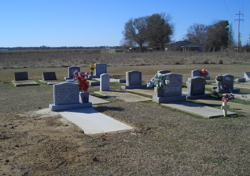
| Memorials | : | 0 |
| Location | : | Atmore, Escambia County, USA |
| Coordinate | : | 31.0880020, -87.5424800 |
| Description | : | To reach this small family cemetery located near Atmore, Alabama, leave Interstate-65 at Exit #54 (also known as Creek #1 or Jack Springs Road). Go north for approximately 500 yards. The cemetery is clearly visible on the left. If traveling south on Jack Springs Road from Uriah, the cemetery is clearly visible on the right a short distance of 3/4 mile south of the Creek Indian headquarters. The Creek Indian museum is on the left. |
frequently asked questions (FAQ):
-
Where is Williams Family Cemetery?
Williams Family Cemetery is located at Atmore, Escambia County ,Alabama ,USA.
-
Williams Family Cemetery cemetery's updated grave count on graveviews.com?
0 memorials
-
Where are the coordinates of the Williams Family Cemetery?
Latitude: 31.0880020
Longitude: -87.5424800
Nearby Cemetories:
1. Rolin Indian Cemetery
Poarch, Escambia County, USA
Coordinate: 31.0813860, -87.5629230
2. Pierce Rabb Cemetery
Atmore, Escambia County, USA
Coordinate: 31.1049060, -87.5223960
3. Davis Cemetery
Freemanville, Escambia County, USA
Coordinate: 31.0726766, -87.5204899
4. Freemanville Church Cemetery
Escambia County, USA
Coordinate: 31.0670260, -87.5216170
5. Judson Indian Cemetery
Escambia County, USA
Coordinate: 31.1110992, -87.5658035
6. Mothershed Cemetery
Freemanville, Escambia County, USA
Coordinate: 31.0557900, -87.5318900
7. Poarch Baptist Church Indian Cemetery
Poarch, Escambia County, USA
Coordinate: 31.1209110, -87.5264240
8. Poarch Mission Cemetery
Escambia County, USA
Coordinate: 31.1208000, -87.5124969
9. New Home Indian Cemetery
Poarch, Escambia County, USA
Coordinate: 31.1101300, -87.4967300
10. Pine Level Cemetery
Atmore, Escambia County, USA
Coordinate: 31.0465508, -87.5072174
11. Oak Hill Cemetery
Atmore, Escambia County, USA
Coordinate: 31.0414009, -87.4955978
12. Milstead Cemetery
Lottie, Baldwin County, USA
Coordinate: 31.1104300, -87.6177700
13. Lucy Hill Cemetery Complex
Atmore, Escambia County, USA
Coordinate: 31.0413710, -87.4840580
14. Brooks Family Cemetery
Perdido, Baldwin County, USA
Coordinate: 31.0658200, -87.6193700
15. First Baptist Church Cemetery
McCullough, Escambia County, USA
Coordinate: 31.1580390, -87.5262200
16. Steadham Cemetery
Escambia County, USA
Coordinate: 31.1567001, -87.5768967
17. Gaines Chapel AME Church Cemetery
Atmore, Escambia County, USA
Coordinate: 31.0294000, -87.4868130
18. Williams Station Cemetery
Escambia County, USA
Coordinate: 31.0227800, -87.4966700
19. Corinth Primitive Baptist Church Cemetery
McCullough, Escambia County, USA
Coordinate: 31.1616420, -87.5656490
20. Jack Springs Cemetery
Escambia County, USA
Coordinate: 31.1646996, -87.5472031
21. McCullough Community Cemetery
McCullough, Escambia County, USA
Coordinate: 31.1649323, -87.5476074
22. Driskell Cemetery
Escambia County, USA
Coordinate: 31.1650009, -87.5466995
23. Mount Shilo Baptist Church Cemetery
Nokomis, Escambia County, USA
Coordinate: 31.0194000, -87.5856000
24. Lottie United Methodist Church Cemetery
Lottie, Baldwin County, USA
Coordinate: 31.0961200, -87.6388900

