
| Memorials | : | 12 |
| Location | : | Williams County, USA |
| Coordinate | : | 41.4417000, -84.3628006 |
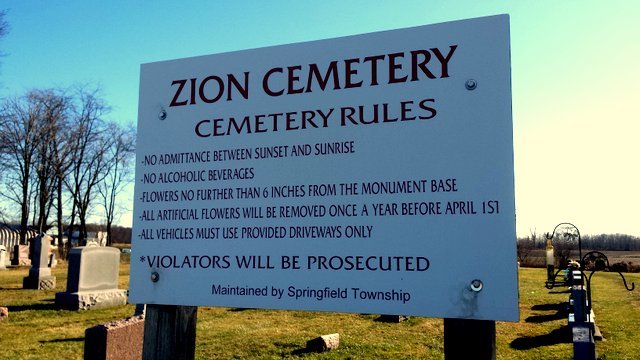
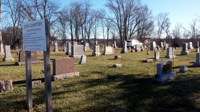
| Description | : | Located just west of the intersection of U.S 6 and State Route 66, near the Williams County/Defiance County line. It is on the site of the former Mount Zion German Reformed Church, and has also been called the Scheer Cemetery. The cemetery is located in Springfield Township, Williams County, Ohio, and is # 12831 (Scheer Cemetery / Zion Cemetery) in “Ohio Cemeteries 1803-2003”, compiled by the Ohio Genealogical Society. The cemetery is registered with the Ohio Division of Real Estate and Professional Licensing (ODRE) as Zion Cemetery with registration license number CGR.0000981882. The U.S. Geological Survey (USGS) Geographic Names... Read More |
frequently asked questions (FAQ):
-
Where is Zion Cemetery?
Zion Cemetery is located at Elm Grove Grange Road (US 6) Williams County ,Ohio , 43557USA.
-
Zion Cemetery cemetery's updated grave count on graveviews.com?
11 memorials
-
Where are the coordinates of the Zion Cemetery?
Latitude: 41.4417000
Longitude: -84.3628006

Nearby Cemetories:
1. Saint Marks Lutheran Cemetery
Defiance, Defiance County, USA
Coordinate: 41.4129240, -84.3257920
2. Saint John Lutheran Church Cemetery
Ridgeville Township, Henry County, USA
Coordinate: 41.4425410, -84.3084650
3. Evansport Cemetery
Evansport, Defiance County, USA
Coordinate: 41.4075012, -84.3964005
4. Buck Cemetery
Williams County, USA
Coordinate: 41.4272003, -84.4250031
5. Saint Johns Methodist Cemetery
Defiance County, USA
Coordinate: 41.3878700, -84.3943100
6. Domersville Cemetery
Defiance, Defiance County, USA
Coordinate: 41.3821983, -84.3244019
7. Boynton Cemetery
Stryker, Williams County, USA
Coordinate: 41.4782982, -84.4389038
8. Oakwood Cemetery
Stryker, Williams County, USA
Coordinate: 41.4978900, -84.4274700
9. Archbold Cemetery
Archbold, Fulton County, USA
Coordinate: 41.5028000, -84.3058014
10. Reform Cemetery
Archbold, Fulton County, USA
Coordinate: 41.5039790, -84.3061070
11. Locust Grove Cemetery
Ridgeville Corners, Henry County, USA
Coordinate: 41.4389650, -84.2558060
12. Saint Peter Lutheran Cemetery
Ridgeville Township, Henry County, USA
Coordinate: 41.4389000, -84.2549973
13. McCauley Cemetery
Defiance County, USA
Coordinate: 41.3697014, -84.4203033
14. Bethlehem Lutheran Cemetery
Defiance County, USA
Coordinate: 41.4050120, -84.2608930
15. Zion Lutheran Church Cemetery
Napoleon, Henry County, USA
Coordinate: 41.4414170, -84.2495930
16. Battenburg Cemetery
Defiance County, USA
Coordinate: 41.3840010, -84.2748520
17. Saint Michaels Catholic Cemetery
Adams Ridge, Defiance County, USA
Coordinate: 41.3631060, -84.3060610
18. French Cemetery
Springfield Township, Williams County, USA
Coordinate: 41.5039100, -84.4485500
19. Metz-Tittle Cemetery
Defiance County, USA
Coordinate: 41.3669014, -84.2857971
20. Poplar Ridge Cemetery
Defiance, Defiance County, USA
Coordinate: 41.3596992, -84.2947006
21. Rupp Cemetery
Archbold, Fulton County, USA
Coordinate: 41.5140110, -84.2771370
22. Beaver Creek Cemetery
Williams County, USA
Coordinate: 41.4808006, -84.4858017
23. Kibble Cemetery
Defiance County, USA
Coordinate: 41.3586769, -84.4374390
24. Defiance County Childrens Home Cemetery
Brunersburg, Defiance County, USA
Coordinate: 41.3461480, -84.4210910