
| Memorials | : | 24 |
| Location | : | Archbold, Fulton County, USA |
| Coordinate | : | 41.5039790, -84.3061070 |
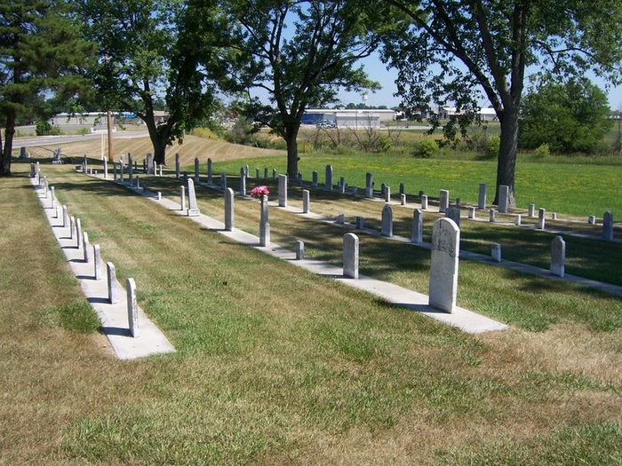
| Description | : | Adjacent to Archbold Cemetery. The cemetery is located in German Township, Fulton County, Ohio, and is # 3769 (Saint Johns Reformed Cemetery / Reform Cemetery / Reformed Cemetery) in “Ohio Cemeteries 1803-2003”, compiled by the Ohio Genealogical Society. The U.S. Geological Survey (USGS) Geographic Names Information System (GNIS) feature ID for the cemetery is 1044924 (Reform Cemetery / Saint Johns Cemetery). |
frequently asked questions (FAQ):
-
Where is Reform Cemetery?
Reform Cemetery is located at S Defiance Street (Ohio State Route 66) Archbold, Fulton County ,Ohio , 43502USA.
-
Reform Cemetery cemetery's updated grave count on graveviews.com?
23 memorials
-
Where are the coordinates of the Reform Cemetery?
Latitude: 41.5039790
Longitude: -84.3061070
Nearby Cemetories:
1. Archbold Cemetery
Archbold, Fulton County, USA
Coordinate: 41.5028000, -84.3058014
2. Rupp Cemetery
Archbold, Fulton County, USA
Coordinate: 41.5140110, -84.2771370
3. Saint Peters Cemetery
Archbold, Fulton County, USA
Coordinate: 41.5428009, -84.2882996
4. Saint James Lutheran Cemetery
Burlington, Fulton County, USA
Coordinate: 41.5428009, -84.2630997
5. Saint John Lutheran Church Cemetery
Ridgeville Township, Henry County, USA
Coordinate: 41.4425410, -84.3084650
6. Pettisville Union Cemetery
Pettisville, Fulton County, USA
Coordinate: 41.5294190, -84.2258910
7. Pettisville Cemetery
Pettisville, Fulton County, USA
Coordinate: 41.5302620, -84.2258690
8. Aeschliman Cemetery
Pettisville, Fulton County, USA
Coordinate: 41.5147018, -84.2192001
9. Wyse Cemetery
Fulton County, USA
Coordinate: 41.5647820, -84.2686700
10. Beck Cemetery
Fulton County, USA
Coordinate: 41.5648620, -84.2682880
11. Pettisville Lutheran Cemetery
Pettisville, Fulton County, USA
Coordinate: 41.5321900, -84.2237400
12. Goll Cemetery
Archbold, Fulton County, USA
Coordinate: 41.5558014, -84.3677979
13. Eckley Cemetery
Eckley, Fulton County, USA
Coordinate: 41.5641600, -84.2491200
14. Locust Grove Cemetery
Ridgeville Corners, Henry County, USA
Coordinate: 41.4389650, -84.2558060
15. Zion Cemetery
Williams County, USA
Coordinate: 41.4417000, -84.3628006
16. Saint Peter Lutheran Cemetery
Ridgeville Township, Henry County, USA
Coordinate: 41.4389000, -84.2549973
17. Zion Lutheran Church Cemetery
Napoleon, Henry County, USA
Coordinate: 41.4414170, -84.2495930
18. Lauber Hill Cemetery
Fulton County, USA
Coordinate: 41.5742410, -84.2681490
19. Johnson Cemetery
Burlington, Fulton County, USA
Coordinate: 41.5791230, -84.3308020
20. Lockport Cemetery
Stryker, Williams County, USA
Coordinate: 41.5466690, -84.3927765
21. Freedom Township Cemetery
Freedom Township, Henry County, USA
Coordinate: 41.4752970, -84.2069960
22. Oakwood Cemetery
Stryker, Williams County, USA
Coordinate: 41.4978900, -84.4274700
23. Saint Marks Lutheran Cemetery
Defiance, Defiance County, USA
Coordinate: 41.4129240, -84.3257920
24. North Pettisville Cemetery
Wauseon, Fulton County, USA
Coordinate: 41.5728190, -84.2200180