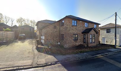
| Memorials | : | 0 |
| Location | : | Burnham, South Bucks District, England |
| Coordinate | : | 51.5358700, -0.6594930 |
| Description | : | Former Congregational Chapel which was built in 1791. Worship took place from Zion Chapel, Gore Road, from 1791 to November 1964. In October 1972 Burnham Congregational Church became Burnham United Reformed Church. |
frequently asked questions (FAQ):
-
Where is Zion Chapel Burial Ground?
Zion Chapel Burial Ground is located at Gore Road, Burnham Burnham, South Bucks District ,Buckinghamshire ,England.
-
Zion Chapel Burial Ground cemetery's updated grave count on graveviews.com?
0 memorials
-
Where are the coordinates of the Zion Chapel Burial Ground?
Latitude: 51.5358700
Longitude: -0.6594930
Nearby Cemetories:
1. St Peter Churchyard
Burnham, South Bucks District, England
Coordinate: 51.5328060, -0.6598430
2. St. Mary's Churchyard
Hitcham, South Bucks District, England
Coordinate: 51.5346430, -0.6750330
3. Nashdom Abbey Cemetery
Burnham, South Bucks District, England
Coordinate: 51.5490600, -0.6739000
4. St. Nicolas' Churchyard
Taplow, South Bucks District, England
Coordinate: 51.5313140, -0.6867530
5. Burnham Abbey Church of St. Mary
Burnham, South Bucks District, England
Coordinate: 51.5155000, -0.6607100
6. The Old Churchyard
Taplow, South Bucks District, England
Coordinate: 51.5312190, -0.6950540
7. St. Mary Churchyard
Farnham Royal, South Bucks District, England
Coordinate: 51.5351250, -0.6149910
8. Cliveden Chapel
Taplow, South Bucks District, England
Coordinate: 51.5571020, -0.6899240
9. Cliveden War Memorial Cemetery
Taplow, South Bucks District, England
Coordinate: 51.5578380, -0.6900160
10. Cliveden House Pet Cemetery
Taplow, South Bucks District, England
Coordinate: 51.5590770, -0.6880610
11. St James the Less Churchyard
Dorney, South Bucks District, England
Coordinate: 51.5030670, -0.6689740
12. St Anne Churchyard
Dropmore, South Bucks District, England
Coordinate: 51.5693020, -0.6530820
13. St Michael Churchyard
Bray, Windsor and Maidenhead Royal Borough, England
Coordinate: 51.5090920, -0.7020450
14. St Nicholas Churchyard
Hedsor, Wycombe District, England
Coordinate: 51.5675780, -0.6924980
15. Holy Trinity Churchyard
Cookham, Windsor and Maidenhead Royal Borough, England
Coordinate: 51.5613910, -0.7074150
16. St. Giles Churchyard
Stoke Poges, South Bucks District, England
Coordinate: 51.5350100, -0.5948900
17. St Luke Cemetery
Maidenhead, Windsor and Maidenhead Royal Borough, England
Coordinate: 51.5265500, -0.7233700
18. Stoke Poges Memorial Gardens
Stoke Poges, South Bucks District, England
Coordinate: 51.5339900, -0.5925200
19. Braywick Cemetery
Maidenhead, Windsor and Maidenhead Royal Borough, England
Coordinate: 51.5086460, -0.7141110
20. Cookham Parish Cemetery
Cookham, Windsor and Maidenhead Royal Borough, England
Coordinate: 51.5485170, -0.7270770
21. St John the Baptist Churchyard
Eton, Windsor and Maidenhead Royal Borough, England
Coordinate: 51.4958960, -0.6303240
22. Slough Cemetery and Crematorium
Slough, Slough Borough, England
Coordinate: 51.5216350, -0.5917440
23. Bray Parish Cemetery
Bray, Windsor and Maidenhead Royal Borough, England
Coordinate: 51.4975520, -0.6989780
24. St Mary Churchyard
Slough, Slough Borough, England
Coordinate: 51.5090790, -0.5991854

