
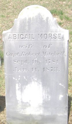
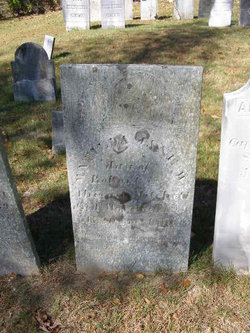
Abigail Morse Mitchell
| Birth | : | 16 Sep 1781 Amesbury, Essex County, Massachusetts, USA |
| Death | : | 11 Jan 1873 New Hampshire, USA |
| Burial | : | Roseville Church Cemetery, Gilmer County, USA |
| Coordinate | : | 39.0207880, -80.9547600 |
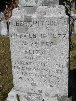
| Inscription | : | Abigail Morse, wife of | Capt. Robert Mitchell, | Sept. 16, 1781. | Jan. 11, 1873. |
| Description | : | Abigail married, on February 12, 1801, Robert Mitchell. |
frequently asked questions (FAQ):
-
Where is Abigail Morse Mitchell's memorial?
Abigail Morse Mitchell's memorial is located at: Roseville Church Cemetery, Gilmer County, USA.
-
When did Abigail Morse Mitchell death?
Abigail Morse Mitchell death on 11 Jan 1873 in New Hampshire, USA
-
Where are the coordinates of the Abigail Morse Mitchell's memorial?
Latitude: 39.0207880
Longitude: -80.9547600
Family Members:
Parent
Spouse
Siblings

Children
Flowers:


Nearby Cemetories:
1. Roseville Church Cemetery
Gilmer County, USA
Coordinate: 39.0207880, -80.9547600
2. Mount Liberty Cemetery
Tanner, Gilmer County, USA
Coordinate: 39.0086390, -80.9616440
3. Goff Cemetery
Burnt House, Ritchie County, USA
Coordinate: 39.0361530, -80.9774200
4. Cooper Family Cemetery
Tanner, Gilmer County, USA
Coordinate: 39.0083050, -80.9255920
5. New Mount Olive Cemetery
Burnt House, Ritchie County, USA
Coordinate: 39.0446100, -80.9340200
6. Cooper Chapel Cemetery
Tanner, Gilmer County, USA
Coordinate: 39.0057800, -80.9161500
7. Burnt House United Methodist Church Cemetery
Burnt House, Ritchie County, USA
Coordinate: 39.0487301, -80.9904470
8. Mount Olive Cemetery
Burnt House, Ritchie County, USA
Coordinate: 39.0531006, -80.9257965
9. Tanner Baptist Church Cemetery
Gilmer County, USA
Coordinate: 38.9814310, -80.9480630
10. Good Shepherd Catholic Cemetery
Tanner, Gilmer County, USA
Coordinate: 38.9811830, -80.9447050
11. Abraham Bush Cemetery
Lucerne, Gilmer County, USA
Coordinate: 39.0184000, -80.8856806
12. Newberne Cemetery
Gilmer County, USA
Coordinate: 39.0465510, -80.8910940
13. Matthews Cemetery
Lucerne, Gilmer County, USA
Coordinate: 39.0112200, -80.8839100
14. N.H. Frederick Cemetery
Burnt House, Ritchie County, USA
Coordinate: 39.0525520, -81.0169120
15. Three Poplar Cemetery
Glenville, Gilmer County, USA
Coordinate: 38.9628600, -80.9445500
16. Trace Fork United Methodist Church Cemetery
Gilmer County, USA
Coordinate: 38.9743580, -81.0005560
17. Bush Cemetery
Gilmer County, USA
Coordinate: 39.0203018, -80.8783035
18. Union Baptist Church Cemetery
Lucerne, Gilmer County, USA
Coordinate: 39.0200800, -80.8779200
19. Wilson Cemetery
Lucerne, Gilmer County, USA
Coordinate: 38.9744900, -80.9013700
20. Woodford Farm Cemetery
Lucerne, Gilmer County, USA
Coordinate: 38.9819600, -80.8880900
21. Britton Cemetery
Hazelgreen, Ritchie County, USA
Coordinate: 39.0841500, -80.9894000
22. Spruce Creek Cemetery
Auburn, Ritchie County, USA
Coordinate: 39.0807300, -80.9083700
23. Holbert Cemetery
Gilmer County, USA
Coordinate: 38.9686012, -80.8944016
24. Hazelgreen Cemetery
Ritchie County, USA
Coordinate: 39.0853004, -81.0021973