
Daniel Morse
| Birth | : | 18 Sep 1745 Massachusetts, USA |
| Death | : | 25 Feb 1826 New Hampshire, USA |
| Burial | : | Mount Auburn Cemetery, Topeka, Shawnee County, USA |
| Coordinate | : | 39.0393982, -95.6500015 |
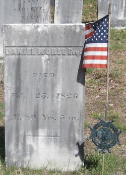
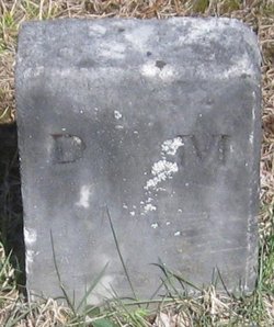
| Inscription | : | Headstone: Daniel Morse, Esq. | Died | Feb. 25, 1826 | Æ. 80 Yrs. 5 m. Footstone: D. M. |
| Description | : | Daniel is the son of Benjamin and Margaret (Bartlett) Morse of Amesbury, Essex co, MA. He married, on November 20, 1766, Miriam Hoyt, daughter of Captain John and Miriam (Currier) Hoyt of West Amesbury. They had 11 children previous to their arrival in Plymouth. Daniel was a soldier in the Revolution and first settled in Newton and after selling his property there. removed to Plymouth. He was a captain and a Justice of the Peace. The family was members of the Plymouth Congregational Church. In addition to the 2 daughters shown on this page there are 9... Read More |
frequently asked questions (FAQ):
-
Where is Daniel Morse's memorial?
Daniel Morse's memorial is located at: Mount Auburn Cemetery, Topeka, Shawnee County, USA.
-
When did Daniel Morse death?
Daniel Morse death on 25 Feb 1826 in New Hampshire, USA
-
Where are the coordinates of the Daniel Morse's memorial?
Latitude: 39.0393982
Longitude: -95.6500015
Family Members:
Spouse
Children

Flowers:


Nearby Cemetories:
1. Topeka Cemetery
Topeka, Shawnee County, USA
Coordinate: 39.0388985, -95.6528015
2. Grace Episcopal Cathedral Sanctuary
Topeka, Shawnee County, USA
Coordinate: 39.0506925, -95.6839273
3. Grace Episcopal Cathedral Columbarium
Topeka, Shawnee County, USA
Coordinate: 39.0511284, -95.6843719
4. Carnegie Hall
Topeka, Shawnee County, USA
Coordinate: 39.0350600, -95.6999100
5. Westminster Presbyterian Church Memorial Garden
Topeka, Shawnee County, USA
Coordinate: 39.0430400, -95.7021700
6. Curtis Family Cemetery
North Topeka, Shawnee County, USA
Coordinate: 39.0792870, -95.6702270
7. Ritchie Cemetery
Topeka, Shawnee County, USA
Coordinate: 39.0228010, -95.7027530
8. Topeka State Hospital Cemetery
Topeka, Shawnee County, USA
Coordinate: 39.0671005, -95.7080994
9. Bethel Cemetery
Topeka, Shawnee County, USA
Coordinate: 39.0085983, -95.5864029
10. Saint Davids Episcopal Church Columbarium
Topeka, Shawnee County, USA
Coordinate: 39.0369860, -95.7259480
11. Memorial Park Cemetery
Topeka, Shawnee County, USA
Coordinate: 39.0619011, -95.7221985
12. Foster Cemetery
Topeka, Shawnee County, USA
Coordinate: 38.9942017, -95.7061005
13. Bennie Lee Graham Memorial Cemetery
Shawnee County, USA
Coordinate: 39.1020584, -95.6836472
14. Mount Calvary Cemetery
Topeka, Shawnee County, USA
Coordinate: 39.0532990, -95.7360992
15. Mount Hope Cemetery
Topeka, Shawnee County, USA
Coordinate: 39.0367393, -95.7386703
16. Rochester Cemetery
Topeka, Shawnee County, USA
Coordinate: 39.1044006, -95.6800003
17. Bauer Cemetery
Topeka, Shawnee County, USA
Coordinate: 38.9864006, -95.5764008
18. Old Grantville Cemetery
Grantville, Jefferson County, USA
Coordinate: 39.0949500, -95.5771300
19. Grantville Cemetery
Grantville, Jefferson County, USA
Coordinate: 39.0957400, -95.5745800
20. Lynn Creek Cemetery
Berryton, Shawnee County, USA
Coordinate: 38.9575005, -95.6408005
21. Security Benefit Association Cemetery
Topeka, Shawnee County, USA
Coordinate: 39.0630989, -95.7606583
22. Emmanuel Cemetery
Watson, Shawnee County, USA
Coordinate: 38.9719009, -95.5744019
23. Zion Cemetery
Watson, Shawnee County, USA
Coordinate: 38.9861984, -95.5481033
24. Abram Burnett Burial Site
Topeka, Shawnee County, USA
Coordinate: 39.0102997, -95.7685776