
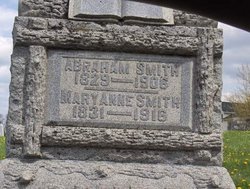
Abraham Smith
| Birth | : | 10 May 1829 Fairfield County, Ohio, USA |
| Death | : | 17 Oct 1906 Fairfield County, Ohio, USA |
| Burial | : | Mineola Cemetery, Mineola, Mills County, USA |
| Coordinate | : | 41.1391130, -95.6941800 |
| Description | : | He was the son of John M. and Mary M. Leathers Smith. He married Mary Anne Kesler on December 22, 1854. They had nine children: Susan, Nancy, William, Sarah, Charles, Emma, Drusilla, Anna and James. In August, 1862, at the age of 33, he enlisted in Co.D, 90th O.V.I. In the Battle of Stone River, Tennessee, on December 31, 1862, he was shot in the arm and a few months later, at Camp Dennison, the cap of a brass button from his coat was found in the wound which then healed but was thereafter painful. He served to the close of... Read More |
frequently asked questions (FAQ):
-
Where is Abraham Smith's memorial?
Abraham Smith's memorial is located at: Mineola Cemetery, Mineola, Mills County, USA.
-
When did Abraham Smith death?
Abraham Smith death on 17 Oct 1906 in Fairfield County, Ohio, USA
-
Where are the coordinates of the Abraham Smith's memorial?
Latitude: 41.1391130
Longitude: -95.6941800
Family Members:
Spouse

Children

Flowers:


Nearby Cemetories:
1. Mineola Cemetery
Mineola, Mills County, USA
Coordinate: 41.1391130, -95.6941800
2. Saint Boniface Catholic Cemetery
Mills County, USA
Coordinate: 41.1419000, -95.7467100
3. Zion Cemetery
Pottawattamie County, USA
Coordinate: 41.1778000, -95.7272000
4. Keg Creek Township Cemetery
Treynor, Pottawattamie County, USA
Coordinate: 41.1913986, -95.6893997
5. Salem Lutheran Church Cemetery
Glenwood, Mills County, USA
Coordinate: 41.1556015, -95.7617035
6. Saint Pauls Evangelical Country Church Cemetery
Dumfries, Pottawattamie County, USA
Coordinate: 41.1748352, -95.7492371
7. Silver City Cemetery
Silver City, Mills County, USA
Coordinate: 41.1042442, -95.6380005
8. Saar's Field Cemetery
Mills County, USA
Coordinate: 41.1255500, -95.7725000
9. West Liberty Cemetery
Glenwood, Mills County, USA
Coordinate: 41.0956001, -95.7536011
10. Glenwood Catholic Cemetery
Glenwood, Mills County, USA
Coordinate: 41.0600000, -95.7453000
11. Glenwood Cemetery
Glenwood, Mills County, USA
Coordinate: 41.0599670, -95.7480240
12. Wall Cemetery
Mineola, Mills County, USA
Coordinate: 41.1157990, -95.8153000
13. Mills County Farm Cemetery
Glenwood, Mills County, USA
Coordinate: 41.0417930, -95.6756530
14. Gowens-Turner Cemetery
Glenwood, Mills County, USA
Coordinate: 41.0715510, -95.7952420
15. Bomar Family Cemetery
Mills County, USA
Coordinate: 41.0369400, -95.6941700
16. Saint Paul Lutheran Cemetery
Treynor, Pottawattamie County, USA
Coordinate: 41.2322000, -95.6380000
17. Lewis Township Cemetery
Council Bluffs, Pottawattamie County, USA
Coordinate: 41.2117004, -95.7938995
18. East Liberty Cemetery
Malvern, Mills County, USA
Coordinate: 41.0592346, -95.6005020
19. Glenwood Resource Center Cemetery
Glenwood, Mills County, USA
Coordinate: 41.0361720, -95.7338590
20. Godsey Cemetery
Mills County, USA
Coordinate: 41.0705986, -95.8075027
21. Martin Chapel Cemetery
Pacific City, Mills County, USA
Coordinate: 41.0611000, -95.8013992
22. Zion Congregational Cemetery
Treynor, Pottawattamie County, USA
Coordinate: 41.2325090, -95.6079200
23. Saint Marys Cemetery
Mills County, USA
Coordinate: 41.1517580, -95.8514000
24. Maple Grove Cemetery
Council Bluffs, Pottawattamie County, USA
Coordinate: 41.2265560, -95.8187100