

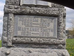
Mary Anne Kesler Smith
| Birth | : | 7 Dec 1831 Fairfield County, Ohio, USA |
| Death | : | 18 Mar 1916 Fairfield County, Ohio, USA |
| Burial | : | Mineola Cemetery, Mineola, Mills County, USA |
| Coordinate | : | 41.1391130, -95.6941800 |
| Description | : | She was a daughter of Jonathon and Nancy Kemp Kesler. On December 22, 1854, she married Abraham Smith. They had the following children: Susan, Nancy, William, Sarah, Charles, Emma, Druscilla, Anna and James. |
frequently asked questions (FAQ):
-
Where is Mary Anne Kesler Smith's memorial?
Mary Anne Kesler Smith's memorial is located at: Mineola Cemetery, Mineola, Mills County, USA.
-
When did Mary Anne Kesler Smith death?
Mary Anne Kesler Smith death on 18 Mar 1916 in Fairfield County, Ohio, USA
-
Where are the coordinates of the Mary Anne Kesler Smith's memorial?
Latitude: 41.1391130
Longitude: -95.6941800
Family Members:
Spouse
Children

Flowers:


Nearby Cemetories:
1. Mineola Cemetery
Mineola, Mills County, USA
Coordinate: 41.1391130, -95.6941800
2. Saint Boniface Catholic Cemetery
Mills County, USA
Coordinate: 41.1419000, -95.7467100
3. Zion Cemetery
Pottawattamie County, USA
Coordinate: 41.1778000, -95.7272000
4. Keg Creek Township Cemetery
Treynor, Pottawattamie County, USA
Coordinate: 41.1913986, -95.6893997
5. Salem Lutheran Church Cemetery
Glenwood, Mills County, USA
Coordinate: 41.1556015, -95.7617035
6. Saint Pauls Evangelical Country Church Cemetery
Dumfries, Pottawattamie County, USA
Coordinate: 41.1748352, -95.7492371
7. Silver City Cemetery
Silver City, Mills County, USA
Coordinate: 41.1042442, -95.6380005
8. Saar's Field Cemetery
Mills County, USA
Coordinate: 41.1255500, -95.7725000
9. West Liberty Cemetery
Glenwood, Mills County, USA
Coordinate: 41.0956001, -95.7536011
10. Glenwood Catholic Cemetery
Glenwood, Mills County, USA
Coordinate: 41.0600000, -95.7453000
11. Glenwood Cemetery
Glenwood, Mills County, USA
Coordinate: 41.0599670, -95.7480240
12. Wall Cemetery
Mineola, Mills County, USA
Coordinate: 41.1157990, -95.8153000
13. Mills County Farm Cemetery
Glenwood, Mills County, USA
Coordinate: 41.0417930, -95.6756530
14. Gowens-Turner Cemetery
Glenwood, Mills County, USA
Coordinate: 41.0715510, -95.7952420
15. Bomar Family Cemetery
Mills County, USA
Coordinate: 41.0369400, -95.6941700
16. Saint Paul Lutheran Cemetery
Treynor, Pottawattamie County, USA
Coordinate: 41.2322000, -95.6380000
17. Lewis Township Cemetery
Council Bluffs, Pottawattamie County, USA
Coordinate: 41.2117004, -95.7938995
18. East Liberty Cemetery
Malvern, Mills County, USA
Coordinate: 41.0592346, -95.6005020
19. Glenwood Resource Center Cemetery
Glenwood, Mills County, USA
Coordinate: 41.0361720, -95.7338590
20. Godsey Cemetery
Mills County, USA
Coordinate: 41.0705986, -95.8075027
21. Martin Chapel Cemetery
Pacific City, Mills County, USA
Coordinate: 41.0611000, -95.8013992
22. Zion Congregational Cemetery
Treynor, Pottawattamie County, USA
Coordinate: 41.2325090, -95.6079200
23. Saint Marys Cemetery
Mills County, USA
Coordinate: 41.1517580, -95.8514000
24. Maple Grove Cemetery
Council Bluffs, Pottawattamie County, USA
Coordinate: 41.2265560, -95.8187100