
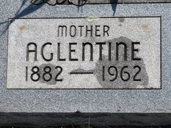


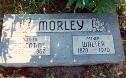
Aglentine “Tina” Cunningham Morley
| Birth | : | 15 Oct 1882 Ottawa County, Kansas, USA |
| Death | : | 24 Jul 1962 Longford, Clay County, Kansas, USA |
| Burial | : | Rose Meron Cemetery, Oak Hill, Clay County, USA |
| Coordinate | : | 39.2194700, -97.3338900 |
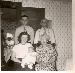
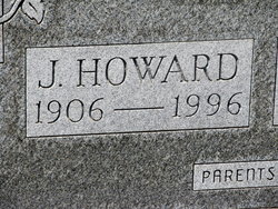
| Description | : | Obit Tina Morley Source: Handwritten copy from newspaper clipping Mrs. Tina Morley, the youngest daughter of Elizabeth and Andrew B. Cunningham was born Oct. 15, 1882 in Ottawa County, Kansas and passed away at her home in Longford, Kans., on July 24, 1962 at the age of 79 years, 9 mos., and 9 days. She was united in marriage to Walter Morley April 16, 1902 at Abilene, Kansas. To this union 5 children were born. Ralph who preceded her in death. She is survived by her husband Walter, two sons Howard Morley of Oak Hill and Harold Morley of Eudora. ... Read More |
frequently asked questions (FAQ):
-
Where is Aglentine “Tina” Cunningham Morley's memorial?
Aglentine “Tina” Cunningham Morley's memorial is located at: Rose Meron Cemetery, Oak Hill, Clay County, USA.
-
When did Aglentine “Tina” Cunningham Morley death?
Aglentine “Tina” Cunningham Morley death on 24 Jul 1962 in Longford, Clay County, Kansas, USA
-
Where are the coordinates of the Aglentine “Tina” Cunningham Morley's memorial?
Latitude: 39.2194700
Longitude: -97.3338900
Family Members:
Parent
Spouse
Siblings

Children
Flowers:


Nearby Cemetories:
1. Rose Meron Cemetery
Oak Hill, Clay County, USA
Coordinate: 39.2194700, -97.3338900
2. Pleasant Valley Cemetery
Oak Hill, Clay County, USA
Coordinate: 39.2468987, -97.2889023
3. Wesleyan Cemetery
Oak Hill, Clay County, USA
Coordinate: 39.2268982, -97.2572021
4. Mount Liberty Church Cemetery
Ottawa County, USA
Coordinate: 39.2489400, -97.4356200
5. Swartwood Cemetery
Longford, Clay County, USA
Coordinate: 39.1323200, -97.3431500
6. Shields Cemetery
Clay County, USA
Coordinate: 39.3208008, -97.3507996
7. Table Mound Cemetery
Idana, Clay County, USA
Coordinate: 39.3141300, -97.2792300
8. Keystone Cemetery
Manchester, Dickinson County, USA
Coordinate: 39.1185989, -97.2917023
9. Hebron Cemetery
Clay County, USA
Coordinate: 39.3213800, -97.2601400
10. Vine Creek Cemetery
Ottawa County, USA
Coordinate: 39.1194000, -97.4180984
11. Athelstane Cemetery
Athelstane Township, Clay County, USA
Coordinate: 39.1768990, -97.1753006
12. Pleasant Ridge Cemetery
Clay County, USA
Coordinate: 39.2789001, -97.1841965
13. Miltonvale Cemetery
Miltonvale, Cloud County, USA
Coordinate: 39.3358002, -97.4447021
14. White Cloud Cemetery
Manchester, Dickinson County, USA
Coordinate: 39.0744019, -97.3525009
15. Idana Cemetery
Idana, Clay County, USA
Coordinate: 39.3574500, -97.2693300
16. Zion Lutheran Cemetery
Clay County, USA
Coordinate: 39.2928009, -97.1557999
17. Mizpah Cemetery
Clay County, USA
Coordinate: 39.2057800, -97.1238500
18. Smith Grave
Miltonvale, Cloud County, USA
Coordinate: 39.3645300, -97.4308700
19. Fairview Cemetery
Lamar, Ottawa County, USA
Coordinate: 39.2928009, -97.5299988
20. Ackley Cemetery
Ottawa County, USA
Coordinate: 39.0893160, -97.4797040
21. Greenridge Cemetery
Dickinson County, USA
Coordinate: 39.1199989, -97.1433029
22. Henry Cemetery
Buckeye, Dickinson County, USA
Coordinate: 39.0828018, -97.1857986
23. Prairiedale Cemetery
Talmage, Dickinson County, USA
Coordinate: 39.0471992, -97.2652969
24. Republican City Cemetery
Clay Center, Clay County, USA
Coordinate: 39.3431015, -97.1628036