
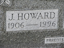

James Howard “Howard” Morley
| Birth | : | 3 Nov 1906 Kansas, USA |
| Death | : | 4 Oct 1996 Abilene, Dickinson County, Kansas, USA |
| Burial | : | Rose Meron Cemetery, Oak Hill, Clay County, USA |
| Coordinate | : | 39.2194700, -97.3338900 |
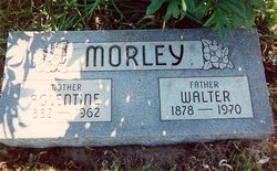
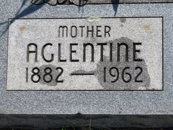
| Description | : | HOWARD MORLEY - Howard Morley, 89, died Friday, October 4, 1996, at Abilene Memorial Hospital. Mr. Morley was born Nov. 3, 1906, south of Abilene,the son of Walter and Aglentine (Cunningham) Morley. He attended Longford High School. Mr. Morley farmed in the Oakhill community and was manager of the Oakhill Elevator before moving to Abilene (in 1970). He was a member of Emmanuel United Methodist Church. He married Anna Smith July 18, 1926, and she preceded him in death Dec. 7, 1968. He then married Dorothy Keikel Jan. 3, 1970, and she survives of the home. Other survivors include a... Read More |
frequently asked questions (FAQ):
-
Where is James Howard “Howard” Morley's memorial?
James Howard “Howard” Morley's memorial is located at: Rose Meron Cemetery, Oak Hill, Clay County, USA.
-
When did James Howard “Howard” Morley death?
James Howard “Howard” Morley death on 4 Oct 1996 in Abilene, Dickinson County, Kansas, USA
-
Where are the coordinates of the James Howard “Howard” Morley's memorial?
Latitude: 39.2194700
Longitude: -97.3338900
Family Members:
Parent
Spouse

Siblings
Flowers:


Nearby Cemetories:
1. Rose Meron Cemetery
Oak Hill, Clay County, USA
Coordinate: 39.2194700, -97.3338900
2. Pleasant Valley Cemetery
Oak Hill, Clay County, USA
Coordinate: 39.2468987, -97.2889023
3. Wesleyan Cemetery
Oak Hill, Clay County, USA
Coordinate: 39.2268982, -97.2572021
4. Mount Liberty Church Cemetery
Ottawa County, USA
Coordinate: 39.2489400, -97.4356200
5. Swartwood Cemetery
Longford, Clay County, USA
Coordinate: 39.1323200, -97.3431500
6. Shields Cemetery
Clay County, USA
Coordinate: 39.3208008, -97.3507996
7. Table Mound Cemetery
Idana, Clay County, USA
Coordinate: 39.3141300, -97.2792300
8. Keystone Cemetery
Manchester, Dickinson County, USA
Coordinate: 39.1185989, -97.2917023
9. Hebron Cemetery
Clay County, USA
Coordinate: 39.3213800, -97.2601400
10. Vine Creek Cemetery
Ottawa County, USA
Coordinate: 39.1194000, -97.4180984
11. Athelstane Cemetery
Athelstane Township, Clay County, USA
Coordinate: 39.1768990, -97.1753006
12. Pleasant Ridge Cemetery
Clay County, USA
Coordinate: 39.2789001, -97.1841965
13. Miltonvale Cemetery
Miltonvale, Cloud County, USA
Coordinate: 39.3358002, -97.4447021
14. White Cloud Cemetery
Manchester, Dickinson County, USA
Coordinate: 39.0744019, -97.3525009
15. Idana Cemetery
Idana, Clay County, USA
Coordinate: 39.3574500, -97.2693300
16. Zion Lutheran Cemetery
Clay County, USA
Coordinate: 39.2928009, -97.1557999
17. Mizpah Cemetery
Clay County, USA
Coordinate: 39.2057800, -97.1238500
18. Smith Grave
Miltonvale, Cloud County, USA
Coordinate: 39.3645300, -97.4308700
19. Fairview Cemetery
Lamar, Ottawa County, USA
Coordinate: 39.2928009, -97.5299988
20. Ackley Cemetery
Ottawa County, USA
Coordinate: 39.0893160, -97.4797040
21. Greenridge Cemetery
Dickinson County, USA
Coordinate: 39.1199989, -97.1433029
22. Henry Cemetery
Buckeye, Dickinson County, USA
Coordinate: 39.0828018, -97.1857986
23. Prairiedale Cemetery
Talmage, Dickinson County, USA
Coordinate: 39.0471992, -97.2652969
24. Republican City Cemetery
Clay Center, Clay County, USA
Coordinate: 39.3431015, -97.1628036