
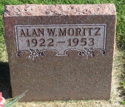
Alan William Moritz
| Birth | : | 3 Jul 1922 Luana, Clayton County, Iowa, USA |
| Death | : | 18 Dec 1953 Waterloo, Black Hawk County, Iowa, USA |
| Burial | : | Clayton Center Cemetery, Clayton Center, Clayton County, USA |
| Coordinate | : | 42.8841705, -91.3225021 |
| Description | : | He married Jean Brown of Garber on March 12, 1943, at Des Moines; three children. For several years he lived in Luana and operated a tavern. He lived in Elkader, where he was employed by the State Bond and Mortgage Company. Alan and Jean also lived in Cedar Rapids and Cedar Falls and moved to Waterloo about six months before his death. In Waterloo he was associated with Investors Diversified Service, Inc. He was a member of Elkader Lodge 72, A.F. and A.M., the Iowa Consistory of Cedar Rapids, Orient of Iowa, the Elks Club and El Kahir Shrine. He died following... Read More |
frequently asked questions (FAQ):
-
Where is Alan William Moritz's memorial?
Alan William Moritz's memorial is located at: Clayton Center Cemetery, Clayton Center, Clayton County, USA.
-
When did Alan William Moritz death?
Alan William Moritz death on 18 Dec 1953 in Waterloo, Black Hawk County, Iowa, USA
-
Where are the coordinates of the Alan William Moritz's memorial?
Latitude: 42.8841705
Longitude: -91.3225021
Family Members:
Parent

Spouse
Siblings
Children

Flowers:


Nearby Cemetories:
1. Clayton Center Cemetery
Clayton Center, Clayton County, USA
Coordinate: 42.8841705, -91.3225021
2. Zion Lutheran Cemetery
Clayton Center, Clayton County, USA
Coordinate: 42.8841705, -91.3249969
3. County Home Cemetery
Clayton Center, Clayton County, USA
Coordinate: 42.8916702, -91.3499985
4. Colony Catholic Cemetery (Defunct)
Read Township, Clayton County, USA
Coordinate: 42.8830000, -91.3580000
5. Saint Joseph Cemetery
Garnavillo, Clayton County, USA
Coordinate: 42.8628006, -91.2502975
6. Garnavillo Community Cemetery
Garnavillo, Clayton County, USA
Coordinate: 42.8656000, -91.2422100
7. Garnavillo Cemetery
Garnavillo, Clayton County, USA
Coordinate: 42.8660300, -91.2390100
8. Elkader Cemetery
Elkader, Clayton County, USA
Coordinate: 42.8541718, -91.4000015
9. Saint Josephs Cemetery
Elkader, Clayton County, USA
Coordinate: 42.8488998, -91.4021988
10. Farmersburg-Wagner Cemetery
Farmersburg, Clayton County, USA
Coordinate: 42.9481010, -91.3700027
11. National Cemetery
National, Clayton County, USA
Coordinate: 42.9536018, -91.2902985
12. Hartman Cemetery
Cox Creek Township, Clayton County, USA
Coordinate: 42.8155360, -91.3880840
13. Meenan Cemetery
Communia, Clayton County, USA
Coordinate: 42.7999862, -91.3584693
14. Krumm Cemetery
Garber, Clayton County, USA
Coordinate: 42.7913760, -91.3023559
15. Norway Lutheran Church Cemetery
Saint Olaf, Clayton County, USA
Coordinate: 42.9352798, -91.4302826
16. Bismark Cemetery
Farmersburg, Clayton County, USA
Coordinate: 42.9790000, -91.3500000
17. Patterson Pioneer Cemetery
Saint Olaf, Clayton County, USA
Coordinate: 42.9216000, -91.4489000
18. Communia Cemetery
Volga Township, Clayton County, USA
Coordinate: 42.7868996, -91.3630981
19. McClelland Cemetery
Garnavillo, Clayton County, USA
Coordinate: 42.8249879, -91.2084641
20. Weymouth Cemetery
Saint Olaf, Clayton County, USA
Coordinate: 42.9278799, -91.4583559
21. Giard Cemetery
Farmersburg, Clayton County, USA
Coordinate: 42.9933014, -91.3080978
22. Wagner Township Cemetery
Saint Olaf, Clayton County, USA
Coordinate: 42.9519386, -91.4513931
23. Clark Family Cemetery
Beulah, Clayton County, USA
Coordinate: 42.9166505, -91.4751415
24. Pioneer Rock Cemetery
Ceres, Clayton County, USA
Coordinate: 42.8230591, -91.1863937