
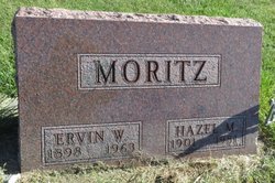
Hazel Mae Lorensten Moritz
| Birth | : | 27 Feb 1901 Hayward, Sawyer County, Wisconsin, USA |
| Death | : | 7 Oct 1981 Postville, Allamakee County, Iowa, USA |
| Burial | : | Clayton Center Cemetery, Clayton Center, Clayton County, USA |
| Coordinate | : | 42.8841705, -91.3225021 |
| Description | : | She married Ervin W. Moritz on 08 Sep 1919; two sons and two daughters. They farmed near Postville for many years and then farmed near Elkader for several more years. They moved to Elkader in 1951. She was active in church work, Eastern Star, Coterie, B.P.W., Federated Women's Club and worked as a dental assistant for 20 years. She lived her last eight years in Monona. She died at the hospital in Postville. |
frequently asked questions (FAQ):
-
Where is Hazel Mae Lorensten Moritz's memorial?
Hazel Mae Lorensten Moritz's memorial is located at: Clayton Center Cemetery, Clayton Center, Clayton County, USA.
-
When did Hazel Mae Lorensten Moritz death?
Hazel Mae Lorensten Moritz death on 7 Oct 1981 in Postville, Allamakee County, Iowa, USA
-
Where are the coordinates of the Hazel Mae Lorensten Moritz's memorial?
Latitude: 42.8841705
Longitude: -91.3225021
Family Members:
Spouse

Children
Flowers:


Nearby Cemetories:
1. Clayton Center Cemetery
Clayton Center, Clayton County, USA
Coordinate: 42.8841705, -91.3225021
2. Zion Lutheran Cemetery
Clayton Center, Clayton County, USA
Coordinate: 42.8841705, -91.3249969
3. County Home Cemetery
Clayton Center, Clayton County, USA
Coordinate: 42.8916702, -91.3499985
4. Colony Catholic Cemetery (Defunct)
Read Township, Clayton County, USA
Coordinate: 42.8830000, -91.3580000
5. Saint Joseph Cemetery
Garnavillo, Clayton County, USA
Coordinate: 42.8628006, -91.2502975
6. Garnavillo Community Cemetery
Garnavillo, Clayton County, USA
Coordinate: 42.8656000, -91.2422100
7. Garnavillo Cemetery
Garnavillo, Clayton County, USA
Coordinate: 42.8660300, -91.2390100
8. Elkader Cemetery
Elkader, Clayton County, USA
Coordinate: 42.8541718, -91.4000015
9. Saint Josephs Cemetery
Elkader, Clayton County, USA
Coordinate: 42.8488998, -91.4021988
10. Farmersburg-Wagner Cemetery
Farmersburg, Clayton County, USA
Coordinate: 42.9481010, -91.3700027
11. National Cemetery
National, Clayton County, USA
Coordinate: 42.9536018, -91.2902985
12. Hartman Cemetery
Cox Creek Township, Clayton County, USA
Coordinate: 42.8155360, -91.3880840
13. Meenan Cemetery
Communia, Clayton County, USA
Coordinate: 42.7999862, -91.3584693
14. Krumm Cemetery
Garber, Clayton County, USA
Coordinate: 42.7913760, -91.3023559
15. Norway Lutheran Church Cemetery
Saint Olaf, Clayton County, USA
Coordinate: 42.9352798, -91.4302826
16. Bismark Cemetery
Farmersburg, Clayton County, USA
Coordinate: 42.9790000, -91.3500000
17. Patterson Pioneer Cemetery
Saint Olaf, Clayton County, USA
Coordinate: 42.9216000, -91.4489000
18. Communia Cemetery
Volga Township, Clayton County, USA
Coordinate: 42.7868996, -91.3630981
19. McClelland Cemetery
Garnavillo, Clayton County, USA
Coordinate: 42.8249879, -91.2084641
20. Weymouth Cemetery
Saint Olaf, Clayton County, USA
Coordinate: 42.9278799, -91.4583559
21. Giard Cemetery
Farmersburg, Clayton County, USA
Coordinate: 42.9933014, -91.3080978
22. Wagner Township Cemetery
Saint Olaf, Clayton County, USA
Coordinate: 42.9519386, -91.4513931
23. Clark Family Cemetery
Beulah, Clayton County, USA
Coordinate: 42.9166505, -91.4751415
24. Pioneer Rock Cemetery
Ceres, Clayton County, USA
Coordinate: 42.8230591, -91.1863937