
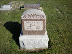
Albert “Al” Elder
| Birth | : | 28 Oct 1865 Davis County, Iowa, USA |
| Death | : | 13 Jan 1940 Bloomfield, Davis County, Iowa, USA |
| Burial | : | St. Mary the Virgin Churchyard, Astley, North Warwickshire Borough, England |
| Coordinate | : | 52.5019060, -1.5432740 |
frequently asked questions (FAQ):
-
Where is Albert “Al” Elder's memorial?
Albert “Al” Elder's memorial is located at: St. Mary the Virgin Churchyard, Astley, North Warwickshire Borough, England.
-
When did Albert “Al” Elder death?
Albert “Al” Elder death on 13 Jan 1940 in Bloomfield, Davis County, Iowa, USA
-
Where are the coordinates of the Albert “Al” Elder's memorial?
Latitude: 52.5019060
Longitude: -1.5432740
Family Members:
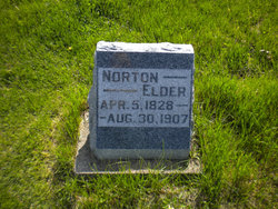
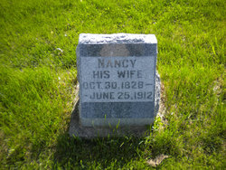
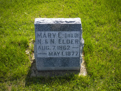
Parent
Spouse

Siblings

Children
Flowers:


Nearby Cemetories:
1. St. Mary the Virgin Churchyard
Astley, North Warwickshire Borough, England
Coordinate: 52.5019060, -1.5432740
2. St. Michaels Parish Church
Arley, North Warwickshire Borough, England
Coordinate: 52.5038140, -1.5703530
3. St Michael's Church
Coventry, Metropolitan Borough of Coventry, England
Coordinate: 52.5036300, -1.5707400
4. St Josephs Roman Catholic Church
Arley, North Warwickshire Borough, England
Coordinate: 52.5013130, -1.5769780
5. Erdbury Priory
Arbury, Nuneaton and Bedworth Borough, England
Coordinate: 52.5002190, -1.5074930
6. St Paul's Churchyard
Stockingford, Nuneaton and Bedworth Borough, England
Coordinate: 52.5191000, -1.5100000
7. St Wilfreds Parish Churchyard
Arley, North Warwickshire Borough, England
Coordinate: 52.5125900, -1.5846500
8. Bucks Hill Cemetery
Stockingford, Nuneaton and Bedworth Borough, England
Coordinate: 52.5317650, -1.5175750
9. St Mary & All Saints Churchyard
Fillongley, North Warwickshire Borough, England
Coordinate: 52.4817860, -1.5878250
10. St Laurence Churchyard
Ansley, North Warwickshire Borough, England
Coordinate: 52.5308620, -1.5737380
11. Congregational Church Burial Ground
Hartshill, North Warwickshire Borough, England
Coordinate: 52.5375900, -1.5227530
12. Corley Parish Churchyard
Corley, North Warwickshire Borough, England
Coordinate: 52.4632100, -1.5577050
13. Hartshill Cemetery
Hartshill, North Warwickshire Borough, England
Coordinate: 52.5440860, -1.5225490
14. Abbey Church
Nuneaton, Nuneaton and Bedworth Borough, England
Coordinate: 52.5256800, -1.4770800
15. St Giles Churchyard
Exhall, Nuneaton and Bedworth Borough, England
Coordinate: 52.4623930, -1.5003010
16. Marston Lane Cemetery
Bedworth, Nuneaton and Bedworth Borough, England
Coordinate: 52.4883470, -1.4678740
17. Friends Meeting House
Hartshill, North Warwickshire Borough, England
Coordinate: 52.5479560, -1.5204940
18. Old Meeting House URC Burial Ground
Bedworth, Nuneaton and Bedworth Borough, England
Coordinate: 52.4815660, -1.4714170
19. All Saints Churchyard
Chilvers Coton, Nuneaton and Bedworth Borough, England
Coordinate: 52.5133100, -1.4659600
20. All Saints Churchyard
Bedworth, Nuneaton and Bedworth Borough, England
Coordinate: 52.4790300, -1.4724590
21. Coventry Road Cemetery
Bedworth, Nuneaton and Bedworth Borough, England
Coordinate: 52.4775590, -1.4734910
22. Our Lady of the Angels Catholic Church
Nuneaton, Nuneaton and Bedworth Borough, England
Coordinate: 52.5174450, -1.4667010
23. St. Leonard Churchyard
Over Whitacre, North Warwickshire Borough, England
Coordinate: 52.5163500, -1.6266000
24. St Nicolas Churchyard
Nuneaton, Nuneaton and Bedworth Borough, England
Coordinate: 52.5214150, -1.4626130