

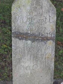
Alexander Garland Croft
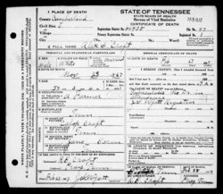
| Birth | : | 23 Nov 1867 Tennessee, USA |
| Death | : | 27 Feb 1927 Cumberland County, Tennessee, USA |
| Burial | : | St Cuthbert Churchyard, Forcett, Richmondshire District, England |
| Coordinate | : | 54.5051660, -1.7304510 |
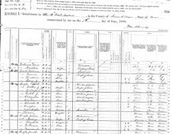
| Description | : | H/O Ollie Randolph Married: 1889 Cumberland Co.Tn. 2nd Wife: Nancy T. Pearson Married: 1905 Cumberland Co.Tn. 3rd Wife: Bertha Seatson Married: 14 March, 1922 Cumberland Co.Tn S/O Caleb & Jane Boren Croft |
frequently asked questions (FAQ):
-
Where is Alexander Garland Croft's memorial?
Alexander Garland Croft's memorial is located at: St Cuthbert Churchyard, Forcett, Richmondshire District, England.
-
When did Alexander Garland Croft death?
Alexander Garland Croft death on 27 Feb 1927 in Cumberland County, Tennessee, USA
-
Where are the coordinates of the Alexander Garland Croft's memorial?
Latitude: 54.5051660
Longitude: -1.7304510
Family Members:
Parent
Spouse

Siblings
Children
Flowers:


Nearby Cemetories:
1. St Cuthbert Churchyard
Forcett, Richmondshire District, England
Coordinate: 54.5051660, -1.7304510
2. St John the Baptist Churchyard
Stanwick St John, Richmondshire District, England
Coordinate: 54.5028550, -1.7155730
3. St. Hilda's Churchyard
Caldwell, Richmondshire District, England
Coordinate: 54.5156390, -1.7508220
4. Gainford Cemetery
Gainford, Durham Unitary Authority, England
Coordinate: 54.5441400, -1.7417800
5. Saint Mary's Churchyard
Gainford, Durham Unitary Authority, England
Coordinate: 54.5453800, -1.7389100
6. St James the Great Churchyard
Melsonby, Richmondshire District, England
Coordinate: 54.4711100, -1.6916100
7. St Osmund's Roman Catholic Churchyard
Gainford, Durham Unitary Authority, England
Coordinate: 54.5476300, -1.7359500
8. All Saints Churchyard
Manfield, Richmondshire District, England
Coordinate: 54.5154080, -1.6573120
9. Saint Mary’s Churchyard
Hutton Magna, Durham Unitary Authority, England
Coordinate: 54.5074500, -1.8060900
10. St. Mary's Churchyard
Piercebridge, Darlington Unitary Authority, England
Coordinate: 54.5366780, -1.6766370
11. St Edwin New Churchyard
High Coniscliffe, Darlington Unitary Authority, England
Coordinate: 54.5338700, -1.6554100
12. St. Edwin Churchyard
High Coniscliffe, Darlington Unitary Authority, England
Coordinate: 54.5322290, -1.6525190
13. St Cuthbert and St Mary Churchyard
Barton, Richmondshire District, England
Coordinate: 54.4754490, -1.6458250
14. St. Peter and St. Felix Churchyard
Kirby Hill, Richmondshire District, England
Coordinate: 54.4546050, -1.7851500
15. St. Agatha and St. Oswin Churchyard
Gilling West, Richmondshire District, England
Coordinate: 54.4414840, -1.7209980
16. Middleton Lodge Chapel
Middleton Tyas, Richmondshire District, England
Coordinate: 54.4562000, -1.6567000
17. St Peter Churchyard
Cleasby, Richmondshire District, England
Coordinate: 54.5123200, -1.6166600
18. Saint Mary's Churchyard
Denton, Darlington Unitary Authority, England
Coordinate: 54.5647600, -1.6626300
19. St John the Evangelist Churchyard
Ingleton, Durham Unitary Authority, England
Coordinate: 54.5795310, -1.7326110
20. St Michael and All Angels Churchyard
Middleton Tyas, Richmondshire District, England
Coordinate: 54.4451400, -1.6390500
21. St Michael and All Angels Churchyard
Barningham, Durham Unitary Authority, England
Coordinate: 54.4895190, -1.8691942
22. Brignall Old Churchyard
Brignall, Durham Unitary Authority, England
Coordinate: 54.5051000, -1.8826400
23. Saint Clare's Abbey
Darlington, Darlington Unitary Authority, England
Coordinate: 54.5250393, -1.5810069
24. Carmel House Convent
Darlington, Darlington Unitary Authority, England
Coordinate: 54.5274820, -1.5819650