
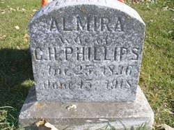
Almira Blackmore Phillips
| Birth | : | 25 Apr 1836 |
| Death | : | 15 Jun 1918 |
| Burial | : | St. George Parish Churchyard, Benenden, Tunbridge Wells Borough, England |
| Coordinate | : | 51.0648720, 0.5794570 |
| Inscription | : | Mother Wife of C.H. Phillips |
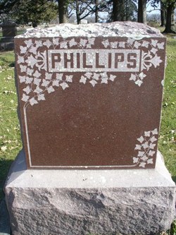
| Description | : | CHARLES HALL9 PHILLIPS (ABIATHAR8, PHILIP7, THOMAS6, JOHN5, RICHARD4, NICHOLAS3, NICHOLAS2, NICHOLAS1) was born April 27, 1820 in Ontario County New York (Source: Vital Records – Town of Ashfield Franklin, Massachusetts , Page 82, Not in Ashfield Franklin, Massachusetts ), and died April 19, 1898 in Lincoln Township, Iowa. He married ALMIRA BLACKMORE 1854 in Allegany New York, daughter of EDWIN BLACKMORE and CYNTHIA WETMORE. She was born April 25, 1836 in Allegany, New York, and died June 15, 1918 in Clearlake, Iowa. |
frequently asked questions (FAQ):
-
Where is Almira Blackmore Phillips's memorial?
Almira Blackmore Phillips's memorial is located at: St. George Parish Churchyard, Benenden, Tunbridge Wells Borough, England.
-
When did Almira Blackmore Phillips death?
Almira Blackmore Phillips death on 15 Jun 1918 in
-
Where are the coordinates of the Almira Blackmore Phillips's memorial?
Latitude: 51.0648720
Longitude: 0.5794570
Family Members:
Parent
Siblings

Children
Flowers:


Nearby Cemetories:
1. St. George Parish Churchyard
Benenden, Tunbridge Wells Borough, England
Coordinate: 51.0648720, 0.5794570
2. Cranbrook Cemetery
Cranbrook, Tunbridge Wells Borough, England
Coordinate: 51.0962250, 0.5541360
3. St. Mary the Virgin Churchyard
Rolvenden, Ashford Borough, England
Coordinate: 51.0506590, 0.6310280
4. St David's Bridge Strict Baptist Chapel
Cranbrook, Tunbridge Wells Borough, England
Coordinate: 51.0953430, 0.5378980
5. St Dunstan's Churchyard
Cranbrook, Tunbridge Wells Borough, England
Coordinate: 51.0973030, 0.5363690
6. Sissinghurst Cemetery
Sissinghurst, Tunbridge Wells Borough, England
Coordinate: 51.1095310, 0.5629240
7. St Peter's Church
Newenden, Ashford Borough, England
Coordinate: 51.0157750, 0.6137190
8. St. Laurence Churchyard
Hawkhurst, Tunbridge Wells Borough, England
Coordinate: 51.0377240, 0.5031610
9. Hawkhurst Cemetery
Hawkhurst, Tunbridge Wells Borough, England
Coordinate: 51.0302300, 0.5051300
10. Tenterden Cemetery
Tenterden, Ashford Borough, England
Coordinate: 51.0676820, 0.6737140
11. Saint Giles' Churchyard
Bodiam, Rother District, England
Coordinate: 51.0074800, 0.5393000
12. All Saints Churchyard
Biddenden, Ashford Borough, England
Coordinate: 51.1150740, 0.6403990
13. Station Road Extension
Tenterden, Ashford Borough, England
Coordinate: 51.0686640, 0.6852830
14. St. Mildred's Churchyard
Tenterden, Ashford Borough, England
Coordinate: 51.0686264, 0.6870960
15. Unitarian Old Meeting House
Tenterden, Ashford Borough, England
Coordinate: 51.0717468, 0.6906880
16. St. Michael and All Angels Churchyard
Tenterden, Ashford Borough, England
Coordinate: 51.0867424, 0.6894140
17. Northiam Cemetery
Northiam, Rother District, England
Coordinate: 50.9926872, 0.5984631
18. Ewhurst Green Churchyard
Ewhurst, Rother District, England
Coordinate: 50.9924300, 0.5572900
19. St. Mary's Churchyard
Frittenden, Tunbridge Wells Borough, England
Coordinate: 51.1391190, 0.5904720
20. St Mary's Churchyard
Northiam, Rother District, England
Coordinate: 50.9911250, 0.6061390
21. Saint Augustine's Churchyard
Flimwell, Rother District, England
Coordinate: 51.0514170, 0.4580350
22. Frittenden Burial Gound
Frittenden, Tunbridge Wells Borough, England
Coordinate: 51.1428480, 0.5870820
23. St John the Baptist
Small Hythe, Ashford Borough, England
Coordinate: 51.0396260, 0.6996060
24. Holy Trinity Churchyard
Hurst Green, Rother District, England
Coordinate: 51.0201400, 0.4691080