

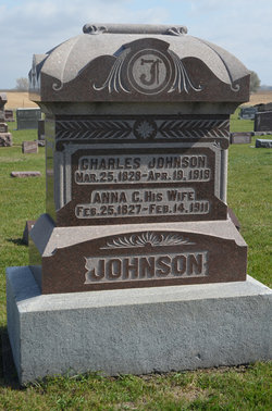
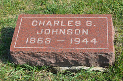
Anna Christina Pehrsdotter Moling Johnson
| Birth | : | 25 Feb 1827 Tjarstad, Kinda kommun, Östergötlands län, Sweden |
| Death | : | 14 Feb 1911 Stratford, Hamilton County, Iowa, USA |
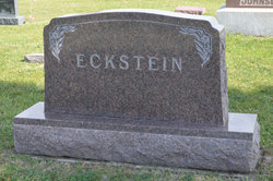
| Burial | : | South Marion Cemetery, Stratford, Hamilton County, USA |
| Coordinate | : | 42.2327995, -93.8735962 |
| Description | : | Stratford Courier February 23, 1911 Mrs. Chas. J. Johnson died in the faith of her Saviour at her home in Stratford Tuesday, February 14, 1911, at the age of 83 years, 11 months and 19 days. She had been in poor health for some time, gradually failing since last summer and was confined to her bed for eleven days, the cause of her death being due to the infirmities of old age. Anna Kristina Moling was born February 25, 1827, in Sjarsta socken, Linkoppings Lan, Sweden. She was confirmed in the Lutheran church at Sweden at the age... Read More |
frequently asked questions (FAQ):
-
Where is Anna Christina Pehrsdotter Moling Johnson's memorial?
Anna Christina Pehrsdotter Moling Johnson's memorial is located at: South Marion Cemetery, Stratford, Hamilton County, USA.
-
When did Anna Christina Pehrsdotter Moling Johnson death?
Anna Christina Pehrsdotter Moling Johnson death on 14 Feb 1911 in Stratford, Hamilton County, Iowa, USA
-
Where are the coordinates of the Anna Christina Pehrsdotter Moling Johnson's memorial?
Latitude: 42.2327995
Longitude: -93.8735962
Family Members:
Spouse
Children
Flowers:


Nearby Cemetories:
1. South Marion Cemetery
Stratford, Hamilton County, USA
Coordinate: 42.2327995, -93.8735962
2. Oakwood Cemetery
Stratford, Hamilton County, USA
Coordinate: 42.2942009, -93.9182968
3. Mineral Ridge Cemetery
Ridgeport, Boone County, USA
Coordinate: 42.1749992, -93.9266968
4. Hooks Point Cemetery
Hamilton County, USA
Coordinate: 42.2944530, -93.9199090
5. Hardin Township Cemetery
Hardin Township, Webster County, USA
Coordinate: 42.2411003, -93.9708023
6. Saint Paul Lutheran Cemetery
Boone, Boone County, USA
Coordinate: 42.1700000, -93.8070000
7. Boone County Poor Farm Cemetery
Boone County, USA
Coordinate: 42.1591100, -93.9159000
8. White Cemetery
Boone County, USA
Coordinate: 42.1777992, -93.9636002
9. Lake Center Cemetery
Stanhope, Hamilton County, USA
Coordinate: 42.2482986, -93.7568970
10. Leininger Cemetery
Boone County, USA
Coordinate: 42.1492004, -93.8356018
11. Lawn Hill Cemetery
Stanhope, Hamilton County, USA
Coordinate: 42.2677994, -93.7611008
12. Nesse Cemetery
Hamilton County, USA
Coordinate: 42.3250008, -93.8933029
13. Neese Cemetery
Homer, Hamilton County, USA
Coordinate: 42.3250000, -93.8935000
14. Linn Cemetery
Pilot Mound, Boone County, USA
Coordinate: 42.2045330, -93.9970230
15. Vegors Cemetery
Webster County, USA
Coordinate: 42.3177986, -93.9421997
16. Mackey Cemetery
Boone County, USA
Coordinate: 42.1675000, -93.7565000
17. Runyan Cemetery
Pilot Mound, Boone County, USA
Coordinate: 42.1749992, -94.0015030
18. Saint Pauls Church Cemetery
Jewell, Hamilton County, USA
Coordinate: 42.2490100, -93.7173400
19. Schlicht Cemetery
Fraser, Boone County, USA
Coordinate: 42.1444200, -93.9780100
20. Bass Cemetery
Dayton, Webster County, USA
Coordinate: 42.2966995, -94.0149994
21. Saratoga Cemetery
Stanhope, Hamilton County, USA
Coordinate: 42.3539009, -93.8167038
22. Pilot Mound Cemetery
Pilot Mound, Boone County, USA
Coordinate: 42.1636200, -94.0282600
23. Ellsworth Clear Lake Cemetery
Randall, Hamilton County, USA
Coordinate: 42.2268930, -93.6926200
24. Bass Point Cemetery
Boone, Boone County, USA
Coordinate: 42.0992012, -93.8957977