
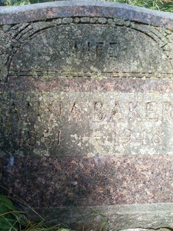
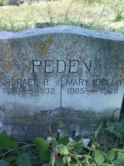
Anna Peden Baker
| Birth | : | 2 May 1861 Kansas, USA |
| Death | : | 3 May 1948 Tipton, Cedar County, Iowa, USA |
| Burial | : | St. Mary the Virgin Churchyard, Henley-on-Thames, South Oxfordshire District, England |
| Coordinate | : | 51.5377790, -0.9017520 |
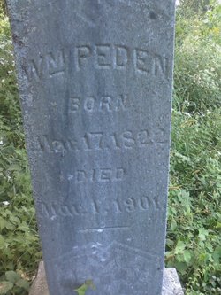
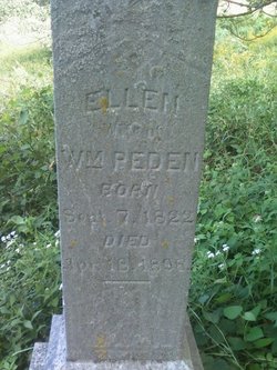
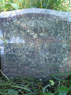
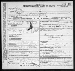
| Description | : | Tipton Advertiser 20 May 1948 Mrs. Anna Walters Anna Peden was born May 2, 1861 in Kansas and passed away in Tipton, Monday, May 3, 1948, at the age of 87 years. She was the daughter of William and Ellen Peden, the last one of a family of 11 children. She was united in marriage to Albert T. Baker in Tipton, June 28,1888. She was preceded in death by her husband and one son in 1932. Surviving are a daughter-in-law, Mrs. Della Peden, 8 grandchildren, Mrs. Mae Oxley and Mrs. George Peden of Iowa City, Mr. Henry Peden of Moscow, Mrs. Roy... Read More |
frequently asked questions (FAQ):
-
Where is Anna Peden Baker's memorial?
Anna Peden Baker's memorial is located at: St. Mary the Virgin Churchyard, Henley-on-Thames, South Oxfordshire District, England.
-
When did Anna Peden Baker death?
Anna Peden Baker death on 3 May 1948 in Tipton, Cedar County, Iowa, USA
-
Where are the coordinates of the Anna Peden Baker's memorial?
Latitude: 51.5377790
Longitude: -0.9017520
Family Members:
Parent
Spouse
Siblings

Children
Flowers:


Nearby Cemetories:
1. St. Mary the Virgin Churchyard
Henley-on-Thames, South Oxfordshire District, England
Coordinate: 51.5377790, -0.9017520
2. Christ Church
Henley-on-Thames, South Oxfordshire District, England
Coordinate: 51.5347880, -0.9032820
3. Holy Trinity Churchyard
Henley-on-Thames, South Oxfordshire District, England
Coordinate: 51.5338500, -0.9066600
4. St Margaret's Churchyard
Harpsden, South Oxfordshire District, England
Coordinate: 51.5219160, -0.9012270
5. Henley-on-Thames Cemetery
Henley-on-Thames, South Oxfordshire District, England
Coordinate: 51.5543570, -0.9271320
6. St. Nicholas' Churchyard
Rotherfield Greys, South Oxfordshire District, England
Coordinate: 51.5351017, -0.9541395
7. St. Mary the Virgin Churchyard
Fawley, Wycombe District, England
Coordinate: 51.5743000, -0.9140000
8. St. James's Churchyard
Bix and Assendon, South Oxfordshire District, England
Coordinate: 51.5610070, -0.9511270
9. St. Peter and St. Paul Churchyard
Shiplake, South Oxfordshire District, England
Coordinate: 51.4980750, -0.8963940
10. St Peter and St Paul Churchyard
Medmenham, Wycombe District, England
Coordinate: 51.5533800, -0.8407110
11. St. Mary's Churchyard
Wargrave, Wokingham Borough, England
Coordinate: 51.4998329, -0.8735808
12. Saint Mary the Virgin Churchyard
Hambleden, Wycombe District, England
Coordinate: 51.5773100, -0.8709500
13. All Saints Churchyard
Rotherfield Peppard, South Oxfordshire District, England
Coordinate: 51.5280531, -0.9725009
14. St. James' Old Churchyard
South Oxfordshire District, England
Coordinate: 51.5769360, -0.9532550
15. All Saints Churchyard
Dunsden Green, South Oxfordshire District, England
Coordinate: 51.4917730, -0.9461650
16. St. Pauls Highmoor Cross
Highmoor, South Oxfordshire District, England
Coordinate: 51.5532740, -0.9910110
17. St Mary the Virgin Churchyard
Hurley, Windsor and Maidenhead Royal Borough, England
Coordinate: 51.5492640, -0.8103620
18. Stonor Park Cemetery
Henley-on-Thames, South Oxfordshire District, England
Coordinate: 51.5967370, -0.9289660
19. St. Peter's Churchyard
Knowl Hill, Windsor and Maidenhead Royal Borough, England
Coordinate: 51.5093351, -0.8126725
20. St. Andrew's Churchyard
Sonning, Wokingham Borough, England
Coordinate: 51.4740300, -0.9131640
21. St Mary's Churchyard
Twyford, Wokingham Borough, England
Coordinate: 51.4763850, -0.8673190
22. St. John the Baptist Churchyard
Kidmore End, South Oxfordshire District, England
Coordinate: 51.5085170, -0.9951240
23. Kidmore End Cemetery
Kidmore End, South Oxfordshire District, England
Coordinate: 51.5071600, -0.9942160
24. St. Bartholomew's Churchyard
Nettlebed, South Oxfordshire District, England
Coordinate: 51.5752360, -0.9936230