
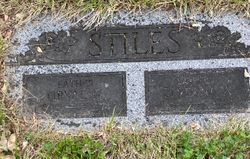
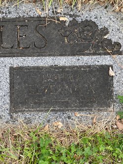
Anola Elverna “Vernie” Wells Stiles
| Birth | : | Mar 1896 Nebraska, USA |
| Death | : | 4 Mar 1989 Council Bluffs, Pottawattamie County, Iowa, USA |
| Burial | : | Cedar Lawn Cemetery, Council Bluffs, Pottawattamie County, USA |
| Coordinate | : | 41.2694016, -95.8182983 |
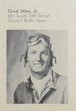
| Description | : | Vernie's family moved from Jefferson county, NE to Page county, Iowa in the early 1900's. Later they went to St. Joseph, MO. Her father worked as a bridge builder and bridge watchman for the railroad. She married Orval Michael Stiles around 1917 and they lived in St. Joseph, MO and in the 1920's moved to Council Bluffs, Iowa. Orval worked for the railroad. Orval and Elverna had children: George R., Orval, Jr., Dorothea, Earl and Shirley. Orval passed away in 1974 (note: his death notice said he was buried in Nebraska) DEATH NOTICE; Omaha World Herald; Tues., 7 Mar 1989 STILES-Anola E. (Vernie),... Read More |
frequently asked questions (FAQ):
-
Where is Anola Elverna “Vernie” Wells Stiles's memorial?
Anola Elverna “Vernie” Wells Stiles's memorial is located at: Cedar Lawn Cemetery, Council Bluffs, Pottawattamie County, USA.
-
When did Anola Elverna “Vernie” Wells Stiles death?
Anola Elverna “Vernie” Wells Stiles death on 4 Mar 1989 in Council Bluffs, Pottawattamie County, Iowa, USA
-
Where are the coordinates of the Anola Elverna “Vernie” Wells Stiles's memorial?
Latitude: 41.2694016
Longitude: -95.8182983
Family Members:
Parent
Spouse

Siblings

Children
Flowers:


Nearby Cemetories:
1. Cedar Lawn Cemetery
Council Bluffs, Pottawattamie County, USA
Coordinate: 41.2694016, -95.8182983
2. Oak Hill Cemetery
Council Bluffs, Pottawattamie County, USA
Coordinate: 41.2700900, -95.8226400
3. Saint Joseph Cemetery
Council Bluffs, Pottawattamie County, USA
Coordinate: 41.2722015, -95.8208008
4. Bikhor Cholim Cemetery
Council Bluffs, Pottawattamie County, USA
Coordinate: 41.2703670, -95.8229350
5. Green Valley Cemetery
Council Bluffs, Pottawattamie County, USA
Coordinate: 41.2743988, -95.8225021
6. Walnut Hill Cemetery
Council Bluffs, Pottawattamie County, USA
Coordinate: 41.2719002, -95.8255997
7. Ridgewood Cemetery
Council Bluffs, Pottawattamie County, USA
Coordinate: 41.2694016, -95.8272018
8. Memorial Park Cemetery
Council Bluffs, Pottawattamie County, USA
Coordinate: 41.2644005, -95.8261032
9. Clark Cemetery
Pottawattamie County, USA
Coordinate: 41.2551610, -95.8223390
10. Fairview Cemetery
Council Bluffs, Pottawattamie County, USA
Coordinate: 41.2703018, -95.8480988
11. Garner Cemetery
Council Bluffs, Pottawattamie County, USA
Coordinate: 41.2956161, -95.8001709
12. Stoker-Graybill Cemetery
Council Bluffs, Pottawattamie County, USA
Coordinate: 41.2532620, -95.7751770
13. Maple Grove Cemetery
Council Bluffs, Pottawattamie County, USA
Coordinate: 41.2265560, -95.8187100
14. Evans Cemetery
Crescent, Pottawattamie County, USA
Coordinate: 41.3255997, -95.8368988
15. Lewis Township Cemetery
Council Bluffs, Pottawattamie County, USA
Coordinate: 41.2117004, -95.7938995
16. Gregg Cemetery
Weston, Pottawattamie County, USA
Coordinate: 41.3330000, -95.7931000
17. Council Point Cemetery
Council Bluffs, Pottawattamie County, USA
Coordinate: 41.2110830, -95.8788610
18. Hazel Dell Cemetery
Council Bluffs, Pottawattamie County, USA
Coordinate: 41.3489723, -95.7939911
19. Trinity Cathedral Columbarium
Omaha, Douglas County, USA
Coordinate: 41.2603900, -95.9393660
20. Saint Columbanus Cemetery
Weston, Pottawattamie County, USA
Coordinate: 41.3429440, -95.7435260
21. Crescent Cemetery
Crescent, Pottawattamie County, USA
Coordinate: 41.3664894, -95.8566208
22. Prospect Hill Cemetery
Omaha, Douglas County, USA
Coordinate: 41.2780991, -95.9593964
23. Saint Pauls Evangelical Country Church Cemetery
Dumfries, Pottawattamie County, USA
Coordinate: 41.1748352, -95.7492371
24. First Central Congregational Columbarium
Omaha, Douglas County, USA
Coordinate: 41.2563456, -95.9658365