
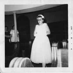

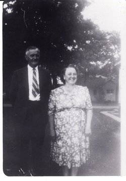
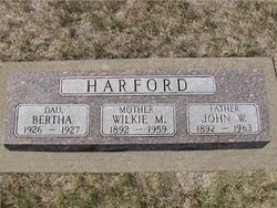
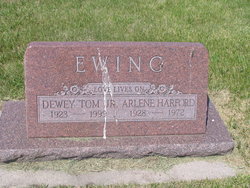
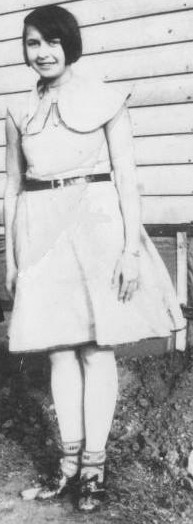
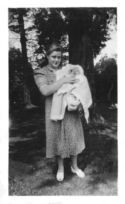
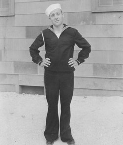
Arlene L. Harford Ewing
| Birth | : | 23 Jan 1928 Redfield, Spink County, South Dakota, USA |
| Death | : | 28 Nov 1972 Omaha, Douglas County, Nebraska, USA |
| Burial | : | Elder Creek Cemetery, Florin, Sacramento County, USA |
| Coordinate | : | 38.5111008, -121.4169006 |
| Plot | : | Div G Blk 014 Lot 001 Grave 003 |
| Description | : | Aberdeen Daily News, Nov. 30, 1972 Dakota Midland News Service REDFIELD -- Services for Mrs. Dewey (Arlene) L. Ewing, 44, will be at 2 p.m. Saturday, Dec. 2 at the First Congregational Church, Redfield, with the Rev. Paul Opsahl officiating. Burial will be in Greenlawn Cemetery. Mrs. Ewing was born Jan. 23, 1928 in Redfield. She lived in the Doland area until 1952, then moved to Hill City until 1963. She lived in Pierre until 1969 when she moved to Omaha where she has lived since. She was married Sept. 25, 1947... Read More |
frequently asked questions (FAQ):
-
Where is Arlene L. Harford Ewing's memorial?
Arlene L. Harford Ewing's memorial is located at: Elder Creek Cemetery, Florin, Sacramento County, USA.
-
When did Arlene L. Harford Ewing death?
Arlene L. Harford Ewing death on 28 Nov 1972 in Omaha, Douglas County, Nebraska, USA
-
Where are the coordinates of the Arlene L. Harford Ewing's memorial?
Latitude: 38.5111008
Longitude: -121.4169006
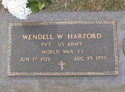
Family Members:
Parent
Spouse
Siblings

Flowers:


Nearby Cemetories:
1. Elder Creek Cemetery
Florin, Sacramento County, USA
Coordinate: 38.5111008, -121.4169006
2. Tinh Xa Ngoc An Temple Columbarium
Sacramento, Sacramento County, USA
Coordinate: 38.5190200, -121.4159500
3. Sacramento County Veterans Memorial Cemetery
Sacramento, Sacramento County, USA
Coordinate: 38.5252838, -121.4239120
4. Sacramento County Cemetery
Sacramento County, USA
Coordinate: 38.5267900, -121.4233700
5. Russian Orthodox Cemetery
Sacramento, Sacramento County, USA
Coordinate: 38.5268800, -121.4244300
6. Sacramento Memorial Lawn Cemetery
Sacramento, Sacramento County, USA
Coordinate: 38.5146484, -121.4380341
7. Home of Peace Cemetery
Sacramento, Sacramento County, USA
Coordinate: 38.5137558, -121.4382782
8. Sacramento County Hospital Cemetery
Sacramento, Sacramento County, USA
Coordinate: 38.5289300, -121.4239100
9. Saint Mary's Catholic Cemetery and Mausoleum
Sacramento, Sacramento County, USA
Coordinate: 38.5298900, -121.4261200
10. Saint Rose Cemetery (Defunct)
Sacramento, Sacramento County, USA
Coordinate: 38.5208015, -121.4672012
11. Pho Minh Temple Columbarium
Sacramento, Sacramento County, USA
Coordinate: 38.5340100, -121.4769000
12. East Lawn Memorial Park
Sacramento, Sacramento County, USA
Coordinate: 38.5612960, -121.4492760
13. Sacramento Pet Cemetery
Sacramento, Sacramento County, USA
Coordinate: 38.4815870, -121.3402080
14. Saint Joseph Cemetery
Sacramento, Sacramento County, USA
Coordinate: 38.5574989, -121.4835968
15. Bellview Cemetery
Sacramento, Sacramento County, USA
Coordinate: 38.5153580, -121.3257446
16. New Helvetia Cemetery (Defunct)
Sacramento, Sacramento County, USA
Coordinate: 38.5731600, -121.4639900
17. Quiet Haven Memorial Park Cemetery
Sacramento, Sacramento County, USA
Coordinate: 38.5109711, -121.3245621
18. San Joaquin Cemetery
Sacramento, Sacramento County, USA
Coordinate: 38.4387665, -121.4034653
19. Trinity Episcopal Cathedral Columbarium
Sacramento, Sacramento County, USA
Coordinate: 38.5705500, -121.4723770
20. Odd Fellows Lawn Cemetery and Mausoleum
Sacramento, Sacramento County, USA
Coordinate: 38.5585000, -121.5011000
21. Buddhist Church of Sacramento Nokotsudo
Sacramento, Sacramento County, USA
Coordinate: 38.5639300, -121.4978400
22. Masonic Lawn Cemetery
Sacramento, Sacramento County, USA
Coordinate: 38.5604720, -121.5032600
23. Sunset Hill Cemetery
Sacramento, Sacramento County, USA
Coordinate: 38.5608000, -121.5037300
24. Sacramento City Cemetery
Sacramento, Sacramento County, USA
Coordinate: 38.5636864, -121.5009537