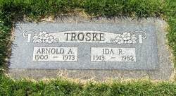
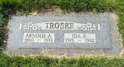
Arnold A Troske
| Birth | : | 23 Jan 1900 Redwood Falls, Redwood County, Minnesota, USA |
| Death | : | 23 Sep 1973 Colville, Stevens County, Washington, USA |
| Burial | : | Obion Chapel Church Cemetery, Cedar Grove, Carroll County, USA |
| Coordinate | : | 35.9198630, -88.5673110 |
frequently asked questions (FAQ):
-
Where is Arnold A Troske's memorial?
Arnold A Troske's memorial is located at: Obion Chapel Church Cemetery, Cedar Grove, Carroll County, USA.
-
When did Arnold A Troske death?
Arnold A Troske death on 23 Sep 1973 in Colville, Stevens County, Washington, USA
-
Where are the coordinates of the Arnold A Troske's memorial?
Latitude: 35.9198630
Longitude: -88.5673110
Family Members:
Parent
Spouse
Siblings
Children
Flowers:
Nearby Cemetories:
1. Obion Chapel Church Cemetery
Cedar Grove, Carroll County, USA
Coordinate: 35.9198630, -88.5673110
2. Carters Chapel Cemetery
Carroll County, USA
Coordinate: 35.9247017, -88.5727997
3. Cool Springs Cumberland Presbyterian Cemetery
Lavinia, Carroll County, USA
Coordinate: 35.9036470, -88.5789430
4. Pearson Cemetery
Cedar Grove, Carroll County, USA
Coordinate: 35.9003660, -88.5531730
5. Zion Church Cemetery
Lavinia, Carroll County, USA
Coordinate: 35.8947920, -88.5787710
6. Brooks Cemetery
Atwood, Carroll County, USA
Coordinate: 35.9430920, -88.5980040
7. Little Grove Cemetery
Lavinia, Carroll County, USA
Coordinate: 35.9142220, -88.6096250
8. Kitty Wright Cemetery
McLemoresville, Carroll County, USA
Coordinate: 35.9455850, -88.5982510
9. Leach Seventh Day Adventist Cemetery
Leach, Carroll County, USA
Coordinate: 35.8909988, -88.5358963
10. Price Cemetery
Trezevant, Carroll County, USA
Coordinate: 35.9534410, -88.5290640
11. Furgerson Cemetery
Cedar Grove, Carroll County, USA
Coordinate: 35.8730830, -88.5732250
12. Clay Family Cemetery
Atwood, Carroll County, USA
Coordinate: 35.9597400, -88.6012900
13. New Independence Church Cemetery
Huntingdon, Carroll County, USA
Coordinate: 35.9513120, -88.5213620
14. New Reedy Creek Baptist Church Cemetery
McLemoresville, Carroll County, USA
Coordinate: 35.9693570, -88.5737870
15. Christian Chapel Cemetery
Cedar Grove, Carroll County, USA
Coordinate: 35.9180984, -88.5038986
16. Moore-Jones Cemetery
Carroll County, USA
Coordinate: 35.9543870, -88.6158080
17. Hopewell Baptist Church Cemetery
Hopewell, Carroll County, USA
Coordinate: 35.8977100, -88.6333600
18. Pleasant Hill Cemetery
Leach, Carroll County, USA
Coordinate: 35.9374770, -88.4971760
19. Mount Olive Cemetery
McLemoresville, Carroll County, USA
Coordinate: 35.9685900, -88.5205840
20. Woodard Cemetery
Cedar Grove, Carroll County, USA
Coordinate: 35.8574250, -88.5639770
21. Leach Full Gospel Church Cemetery
Leach, Carroll County, USA
Coordinate: 35.9337950, -88.4917900
22. Clark Family Cemetery
Atwood, Carroll County, USA
Coordinate: 35.9556900, -88.6333900
23. Leach Cemetery
Atwood, Carroll County, USA
Coordinate: 35.9359000, -88.6448800
24. Old Woodard Cemetery
Cedar Grove, Carroll County, USA
Coordinate: 35.8570180, -88.5457830


