
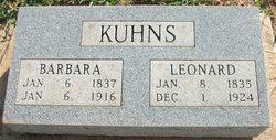
Barbara Slabaugh Kuhns
| Birth | : | 6 Jan 1837 |
| Death | : | 6 Jan 1916 |
| Burial | : | St. Lawrence Churchyard, Barton, City of Preston, England |
| Coordinate | : | 53.8289213, -2.7366654 |
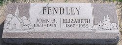
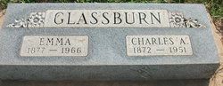
| Description | : | Barbara (Slabach) Kuhns of near Freeport, Kans., died from a severe attack of pneumonia, Jan. 5, 1916; aged 1 day less than 79 years. She was married to Leonard Kuhns to which union 11 children were born, of whom 4 with her husband survive her. They are Emma Glassburn and Lizzie Fendly of Freeport, , Albert of Anthony, Mary Dohring, of Brownsville, Ore. She had accepted Christ as her Savior in her youth, wltho she will be greatly missed in her home we have the confidence that our loss is her gain, for during her short... Read More |
frequently asked questions (FAQ):
-
Where is Barbara Slabaugh Kuhns's memorial?
Barbara Slabaugh Kuhns's memorial is located at: St. Lawrence Churchyard, Barton, City of Preston, England.
-
When did Barbara Slabaugh Kuhns death?
Barbara Slabaugh Kuhns death on 6 Jan 1916 in
-
Where are the coordinates of the Barbara Slabaugh Kuhns's memorial?
Latitude: 53.8289213
Longitude: -2.7366654
Family Members:
Parent
Spouse

Siblings
Children
Flowers:


Nearby Cemetories:
1. St Mary's Newhouse
Barton, City of Preston, England
Coordinate: 53.8205240, -2.7406500
2. St. Hilda's Churchyard
Bilsborrow, Wyre Borough, England
Coordinate: 53.8522170, -2.7420090
3. St. John Baptist Churchyard
Broughton-in-Amounderness, City of Preston, England
Coordinate: 53.8033700, -2.7170400
4. Saint Anne's Church
Woodplumpton, City of Preston, England
Coordinate: 53.8038130, -2.7621940
5. St. Mary the Virgin Churchyard
Goosnargh, City of Preston, England
Coordinate: 53.8266470, -2.6707030
6. St Andrew George Haydock Roman Catholic Churchyard
Cottam, City of Preston, England
Coordinate: 53.7879280, -2.7591570
7. St. Mary's Churchyard
Preston, City of Preston, England
Coordinate: 53.8010830, -2.6779600
8. Whittingham Hospital Cemetery
Goosnargh, City of Preston, England
Coordinate: 53.8208401, -2.6613468
9. St Thomas Churchyard
Claughton-on-Brock, Wyre Borough, England
Coordinate: 53.8752030, -2.7199160
10. St. Peters Churchyard
Inskip with Sowerby, Wyre Borough, England
Coordinate: 53.8347100, -2.8175200
11. Church of St James
Goosnargh, City of Preston, England
Coordinate: 53.8657750, -2.6719410
12. Inskip Baptist Churchyard
Inskip with Sowerby, Wyre Borough, England
Coordinate: 53.8353150, -2.8299610
13. Christ Church Churchyard
Fulwood, City of Preston, England
Coordinate: 53.7771920, -2.7028700
14. St. Helen's Churchyard
Kirkland (Churchtown), Wyre Borough, England
Coordinate: 53.8790700, -2.7901000
15. St. Michael’s Churchyard
St Michael's on Wyre, Wyre Borough, England
Coordinate: 53.8628050, -2.8195430
16. St. Andrew's Churchyard
Ashton-on-Ribble, City of Preston, England
Coordinate: 53.7687030, -2.7359180
17. St. Mary's Churchyard
Lea, City of Preston, England
Coordinate: 53.7733810, -2.7942770
18. St. Michael's Churchyard
Grimsargh, City of Preston, England
Coordinate: 53.7990710, -2.6352530
19. St Walburge's RC Church
Preston, City of Preston, England
Coordinate: 53.7629690, -2.7149620
20. Saint Peter Churchyard
Preston, City of Preston, England
Coordinate: 53.7634100, -2.7080700
21. Christ Churchyard
Treales, Fylde Borough, England
Coordinate: 53.8045970, -2.8440710
22. St. Ignatius RC Churchyard
Preston, City of Preston, England
Coordinate: 53.7635270, -2.6965870
23. Holy Trinity
Preston, City of Preston, England
Coordinate: 53.7613030, -2.7030580
24. St. John the Evangelist Churchyard
Clifton, Fylde Borough, England
Coordinate: 53.7758600, -2.8158500