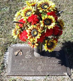
Betty Jean Peden Farrow
| Birth | : | 30 Apr 1930 Fountain Inn, Greenville County, South Carolina, USA |
| Death | : | 10 Apr 2005 Springfield, Fairfax County, Virginia, USA |
| Burial | : | St Peter in the Forest, Allendale, Northumberland Unitary Authority, England |
| Coordinate | : | 54.8313100, -2.2350600 |
| Description | : | Betty Peden Farrow Fountain Inn Betty Peden Farrow "Miss Betty" passed away April 10, 2005, at the home of her daughter in Springfield, Va. She was born on April 30, 1930, in Fountain Inn to Robert Wilton and Ethel Abercrombie Peden. She was the beloved granddaughter of John and Catherine Peden. Ms. Farrow was a graduate of Fork Shoals High School and Draughn's Business College. She was employed at Woodside Mills, the Tribune Times, Cannon Funeral Home, and for 22 years was the secretary of First Baptist Church of Fountain Inn. Betty Farrow loved and was loved by the people of Fountain Inn, especially those... Read More |
frequently asked questions (FAQ):
-
Where is Betty Jean Peden Farrow's memorial?
Betty Jean Peden Farrow's memorial is located at: St Peter in the Forest, Allendale, Northumberland Unitary Authority, England.
-
When did Betty Jean Peden Farrow death?
Betty Jean Peden Farrow death on 10 Apr 2005 in Springfield, Fairfax County, Virginia, USA
-
Where are the coordinates of the Betty Jean Peden Farrow's memorial?
Latitude: 54.8313100
Longitude: -2.2350600
Family Members:
Parent
Siblings
Children
Flowers:
Nearby Cemetories:
1. St Peter in the Forest
Allendale, Northumberland Unitary Authority, England
Coordinate: 54.8313100, -2.2350600
2. Carrshield Anglican Churchyard
Allendale, Northumberland Unitary Authority, England
Coordinate: 54.8229010, -2.3083050
3. Limestone Brae, Wesleyan Methodist Chapel
Allendale, Northumberland Unitary Authority, England
Coordinate: 54.8425890, -2.3207386
4. Limestone Brae Burial Ground
Allendale, Northumberland Unitary Authority, England
Coordinate: 54.8441180, -2.3233520
5. Allendale Woodland Cemetery
Allendale, Northumberland Unitary Authority, England
Coordinate: 54.8932624, -2.2618136
6. Allendale Old Cemetery
Allendale, Northumberland Unitary Authority, England
Coordinate: 54.8941650, -2.2612690
7. Friends Meeting House
Allendale, Northumberland Unitary Authority, England
Coordinate: 54.8957750, -2.2598490
8. St. Cuthbert's Churchyard
Allendale, Northumberland Unitary Authority, England
Coordinate: 54.8978260, -2.2545020
9. Copt Hill Churchyard
Cowshill, Durham Unitary Authority, England
Coordinate: 54.7626700, -2.2320470
10. Saint Thomas Heatherycleugh
Cowshill, Durham Unitary Authority, England
Coordinate: 54.7601700, -2.2264200
11. Burtree Ford Cemetery
Cowshill, Durham Unitary Authority, England
Coordinate: 54.7587910, -2.2286680
12. St John's Churchyard
Nenthead, Eden District, England
Coordinate: 54.7903000, -2.3434180
13. High House Methodist Chapel Graveyard
Allendale, Northumberland Unitary Authority, England
Coordinate: 54.8844090, -2.3285218
14. Nenthead Cemetery
Nenthead, Eden District, England
Coordinate: 54.7947260, -2.3536210
15. Keenley Methodist Chapel Graveyard
Allendale, Northumberland Unitary Authority, England
Coordinate: 54.9053170, -2.3075580
16. St James Churchyard
Hunstanworth, Durham Unitary Authority, England
Coordinate: 54.8358650, -2.0807750
17. Old Churchyard
Eastgate, Durham Unitary Authority, England
Coordinate: 54.7751710, -2.0933400
18. Rookhope Cemetery
Eastgate, Durham Unitary Authority, England
Coordinate: 54.7744000, -2.0916800
19. Church of Saint Mary
Blanchland, Northumberland Unitary Authority, England
Coordinate: 54.8484000, -2.0541000
20. St John the Evangelist Churchyard
Garrigill, Eden District, England
Coordinate: 54.7677610, -2.3977800
21. Redwing Chapel Churchyard
Garrigill, Eden District, England
Coordinate: 54.7702390, -2.4071080
22. St Augustine Churchyard
Alston, Eden District, England
Coordinate: 54.8128980, -2.4397250
23. Alston Cemetery
Alston, Eden District, England
Coordinate: 54.8083540, -2.4416430
24. All Saints Churchyard
Eastgate, Durham Unitary Authority, England
Coordinate: 54.7445590, -2.0745270


