
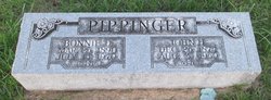
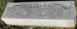
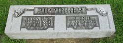
Bonnie Dea Dugan Pippinger
| Birth | : | 25 Mar 1890 Clay Township, Shelby County, Missouri, USA |
| Death | : | 14 Jul 1970 Clarence, Shelby County, Missouri, USA |
| Burial | : | Rutherford Cemetery, Rutherford, Gibson County, USA |
| Coordinate | : | 36.1258011, -88.9989014 |
| Plot | : | BUNN Block 1 Row 4 Lot 24n |
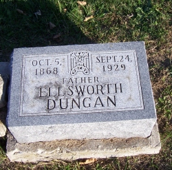
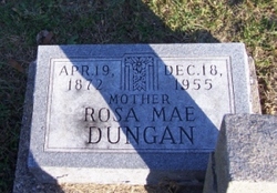
| Description | : | Married John Henry Pippenger on 06 Nov 1907 in Clarence, Shelby County, Missouri. MO d/c 70 0031154 (Contributor: Pam Witherow) MRS. BONNIE PIPPINGER CLARENCE, Mo. — Mrs. Bonnie Pippinger, 80, of Clarence, died Tuesday (July 14, 1970) in her home. Services will be held Friday at 2 p.m. in the Greening Funeral Home, with the Rev. Charles Embree officiating. Burial will be in Maplewood Cemetery. Mrs. Pippinger was born in Shelby County March 25, 1890, a daughter of Ellsworth and Rosa Wells Dungan. She was a member of the Clarence Christian Church. Surviving is a son, R. L. Pippinger... Read More |
frequently asked questions (FAQ):
-
Where is Bonnie Dea Dugan Pippinger's memorial?
Bonnie Dea Dugan Pippinger's memorial is located at: Rutherford Cemetery, Rutherford, Gibson County, USA.
-
When did Bonnie Dea Dugan Pippinger death?
Bonnie Dea Dugan Pippinger death on 14 Jul 1970 in Clarence, Shelby County, Missouri, USA
-
Where are the coordinates of the Bonnie Dea Dugan Pippinger's memorial?
Latitude: 36.1258011
Longitude: -88.9989014
Family Members:
Parent
Spouse
Siblings


Nearby Cemetories:
1. Rutherford Cemetery
Rutherford, Gibson County, USA
Coordinate: 36.1258011, -88.9989014
2. Crockett Memorial Plot
Rutherford, Gibson County, USA
Coordinate: 36.1299620, -88.9871980
3. Flowers Chapel Cemetery
Rutherford, Gibson County, USA
Coordinate: 36.1198820, -89.0265080
4. Carroll Cemetery
Rutherford, Gibson County, USA
Coordinate: 36.1453900, -89.0140800
5. Wilkes Cemetery
Rutherford, Gibson County, USA
Coordinate: 36.1097380, -89.0214500
6. Old Bluff Cemetery
Rutherford, Gibson County, USA
Coordinate: 36.1417870, -88.9751880
7. Taylor Family Cemetery
Rutherford, Gibson County, USA
Coordinate: 36.1049700, -89.0226300
8. Hopper Cemetery
Dyer, Gibson County, USA
Coordinate: 36.0936200, -88.9878680
9. New Victory MB Church Cemetery
Rutherford, Gibson County, USA
Coordinate: 36.1596780, -88.9978150
10. Liberty Grove Cemetery
Rutherford, Gibson County, USA
Coordinate: 36.1439760, -89.0371100
11. Keathley & Peel Family Cemetery
Gibson County, USA
Coordinate: 36.1651820, -88.9949470
12. Flowers - Wright Cemetery
Dyer, Gibson County, USA
Coordinate: 36.0951100, -89.0348700
13. Smithson-Askew Cemetery
Rutherford, Gibson County, USA
Coordinate: 36.1667300, -89.0159600
14. Bobbitt Cemetery
Dyer, Gibson County, USA
Coordinate: 36.0774994, -88.9850006
15. Thompson Cemetery
Rutherford, Gibson County, USA
Coordinate: 36.1047220, -89.0553430
16. Mount Olive Cemetery
Dyer, Gibson County, USA
Coordinate: 36.0807991, -89.0278015
17. Keas Cemetery
Dyer, Gibson County, USA
Coordinate: 36.0769005, -88.9757996
18. Beech Grove Cemetery
Rutherford, Gibson County, USA
Coordinate: 36.1591988, -88.9464035
19. Rossons Cemetery
Kenton, Gibson County, USA
Coordinate: 36.1799158, -89.0083141
20. Bells Chapel Cemetery
Dyer, Gibson County, USA
Coordinate: 36.1164017, -89.0686035
21. Walnut Grove Baptist Church Cemetery
Gibson County, USA
Coordinate: 36.1742000, -88.9606000
22. Apostolic Faith Tabernacle Cemetery
Dyer, Gibson County, USA
Coordinate: 36.0732460, -88.9674180
23. Salem Cemetery
Rutherford, Gibson County, USA
Coordinate: 36.1217003, -88.9266968
24. Oakwood Cemetery
Dyer, Gibson County, USA
Coordinate: 36.0619011, -88.9875031