
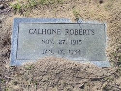
Calhone Roberts
| Birth | : | 27 Nov 1915 |
| Death | : | 17 Jan 1934 |
| Burial | : | Oak Grove Cemetery, Missouri Valley, Harrison County, USA |
| Coordinate | : | 41.5167007, -95.8649979 |
| Description | : | The State Newspaper January 21 1934 Special to the Sate Conway Jan 20-Funeral services for Calhoun Roberts, 16, of the El Bethel section, who died at his home Wednesday morning after an illness of about three months, and a few days ago developed pneumonia was held Thursday morning at Brown Swamp Methodist Church. Services were conducted by his pastor, the Rev. T. E. Derrick, assisted by a former pastor, the Rev. Ernest Dugan of Hampton. Interment took place in the Brown Swamp Cemetery. The youth is survived by his father and mother, Mr.... Read More |
frequently asked questions (FAQ):
-
Where is Calhone Roberts's memorial?
Calhone Roberts's memorial is located at: Oak Grove Cemetery, Missouri Valley, Harrison County, USA.
-
When did Calhone Roberts death?
Calhone Roberts death on 17 Jan 1934 in
-
Where are the coordinates of the Calhone Roberts's memorial?
Latitude: 41.5167007
Longitude: -95.8649979
Family Members:
Parent

Siblings


Flowers:


Nearby Cemetories:
1. Oak Grove Cemetery
Missouri Valley, Harrison County, USA
Coordinate: 41.5167007, -95.8649979
2. Branson Cemetery
Loveland, Pottawattamie County, USA
Coordinate: 41.4846992, -95.8606033
3. Rose Hill Memorial Gardens
Missouri Valley, Harrison County, USA
Coordinate: 41.5656000, -95.8897000
4. Hurleys Evergreen Cemetery
Harrison County, USA
Coordinate: 41.5700989, -95.8618698
5. Mount Carmel Cemetery
Missouri Valley, Harrison County, USA
Coordinate: 41.5675011, -95.8897018
6. Saint Bridgets Cemetery
Honey Creek, Pottawattamie County, USA
Coordinate: 41.4664001, -95.8289032
7. Crook Cemetery
Honey Creek, Pottawattamie County, USA
Coordinate: 41.4581330, -95.8737000
8. Champan Frazier Cemetery
Harrison County, USA
Coordinate: 41.5773500, -95.8933500
9. Allen Cemetery
Pottawattamie County, USA
Coordinate: 41.4427986, -95.8550034
10. Frazier Cemetery
Missouri Valley, Harrison County, USA
Coordinate: 41.5932999, -95.8375015
11. Grange Cemetery
Honey Creek, Pottawattamie County, USA
Coordinate: 41.4446678, -95.8034668
12. Linnwood Cemetery
Harrison County, USA
Coordinate: 41.5589200, -95.7502100
13. Reels Cemetery
Crescent, Pottawattamie County, USA
Coordinate: 41.4234100, -95.8321700
14. William C McIntosh Cemetery
Crescent, Pottawattamie County, USA
Coordinate: 41.4088745, -95.8477097
15. Saint Pauls Lutheran Cemetery
Neola, Pottawattamie County, USA
Coordinate: 41.4337000, -95.7607000
16. Harris Grove Cemetery
Beebeetown, Harrison County, USA
Coordinate: 41.5782928, -95.7262192
17. Calhoun Cemetery
Calhoun, Harrison County, USA
Coordinate: 41.6391983, -95.8938980
18. Fort Calhoun Cemetery
Fort Calhoun, Washington County, USA
Coordinate: 41.4581375, -96.0352020
19. Logan Cemetery
Logan, Harrison County, USA
Coordinate: 41.6487579, -95.7843170
20. Crescent Cemetery
Crescent, Pottawattamie County, USA
Coordinate: 41.3664894, -95.8566208
21. Shipley Cemetery
Washington County, USA
Coordinate: 41.3932991, -95.9828033
22. Bethel Cemetery
Logan, Harrison County, USA
Coordinate: 41.6239014, -95.6999969
23. Castor Cemetery
Underwood, Pottawattamie County, USA
Coordinate: 41.4127040, -95.6887490
24. Cox Cemetery
Persia, Harrison County, USA
Coordinate: 41.5391998, -95.6418991