
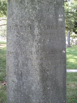
| Birth | : | 1 Jul 1749 Newport, Newport County, Rhode Island, USA |
| Death | : | Dec 1783 At Sea |
| Burial | : | Grange Cemetery, Honey Creek, Pottawattamie County, USA |
| Coordinate | : | 41.4446678, -95.8034668 |
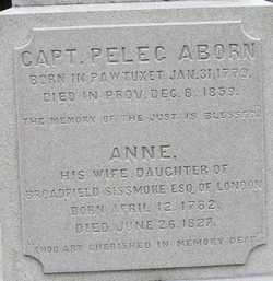
| Description | : | Son of Captain Joseph Aborn and Elizabeth Scranton. Like his father he was a master mariner. He was a privateer Captain of the new 12 gun sloop Chance. It sailed from Providence on May 11, 1782 and within a few days was captured by the 26 gun British ship Belisarius. He was brought to Brooklyn NY and imprisoned on the British prison ship Jersey along with Sylvester Rhodes. He and several others were exchanged after the intervention of General George Washington. He would later put to sea again and was bound for the West Indies and during a... Read More |
frequently asked questions (FAQ):
-
Where is Capt Daniel Aborn's memorial?
Capt Daniel Aborn's memorial is located at: Grange Cemetery, Honey Creek, Pottawattamie County, USA.
-
When did Capt Daniel Aborn death?
Capt Daniel Aborn death on Dec 1783 in At Sea
-
Where are the coordinates of the Capt Daniel Aborn's memorial?
Latitude: 41.4446678
Longitude: -95.8034668
Family Members:
Spouse

Children
Flowers:


Nearby Cemetories:
1. Grange Cemetery
Honey Creek, Pottawattamie County, USA
Coordinate: 41.4446678, -95.8034668
2. Saint Bridgets Cemetery
Honey Creek, Pottawattamie County, USA
Coordinate: 41.4664001, -95.8289032
3. Reels Cemetery
Crescent, Pottawattamie County, USA
Coordinate: 41.4234100, -95.8321700
4. Saint Pauls Lutheran Cemetery
Neola, Pottawattamie County, USA
Coordinate: 41.4337000, -95.7607000
5. Allen Cemetery
Pottawattamie County, USA
Coordinate: 41.4427986, -95.8550034
6. William C McIntosh Cemetery
Crescent, Pottawattamie County, USA
Coordinate: 41.4088745, -95.8477097
7. Crook Cemetery
Honey Creek, Pottawattamie County, USA
Coordinate: 41.4581330, -95.8737000
8. Branson Cemetery
Loveland, Pottawattamie County, USA
Coordinate: 41.4846992, -95.8606033
9. Oak Grove Cemetery
Missouri Valley, Harrison County, USA
Coordinate: 41.5167007, -95.8649979
10. Crescent Cemetery
Crescent, Pottawattamie County, USA
Coordinate: 41.3664894, -95.8566208
11. Castor Cemetery
Underwood, Pottawattamie County, USA
Coordinate: 41.4127040, -95.6887490
12. Hazel Dell Cemetery
Council Bluffs, Pottawattamie County, USA
Coordinate: 41.3489723, -95.7939911
13. H G Fisher Cemetery
Underwood, Pottawattamie County, USA
Coordinate: 41.3838997, -95.6889038
14. Saint Columbanus Cemetery
Weston, Pottawattamie County, USA
Coordinate: 41.3429440, -95.7435260
15. Gregg Cemetery
Weston, Pottawattamie County, USA
Coordinate: 41.3330000, -95.7931000
16. Downsville Cemetery
Pottawattamie County, USA
Coordinate: 41.3502998, -95.7039032
17. Linnwood Cemetery
Harrison County, USA
Coordinate: 41.5589200, -95.7502100
18. Evans Cemetery
Crescent, Pottawattamie County, USA
Coordinate: 41.3255997, -95.8368988
19. Hurleys Evergreen Cemetery
Harrison County, USA
Coordinate: 41.5700989, -95.8618698
20. Rose Hill Memorial Gardens
Missouri Valley, Harrison County, USA
Coordinate: 41.5656000, -95.8897000
21. Mount Carmel Cemetery
Missouri Valley, Harrison County, USA
Coordinate: 41.5675011, -95.8897018
22. Saint Patricks Cemetery
Neola, Pottawattamie County, USA
Coordinate: 41.4581300, -95.6183600
23. Neola Township Cemetery
Neola, Pottawattamie County, USA
Coordinate: 41.4591400, -95.6183800
24. Shipley Cemetery
Washington County, USA
Coordinate: 41.3932991, -95.9828033