
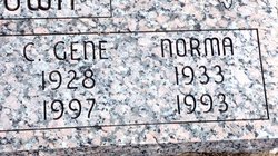
| Birth | : | 28 Apr 1928 Clyde, Cloud County, Kansas, USA |
| Death | : | 16 Mar 1997 Clyde, Cloud County, Kansas, USA |
| Burial | : | Mount Calvary Cemetery, Clyde, Cloud County, USA |
| Coordinate | : | 39.5917015, -97.4143982 |
| Plot | : | Site D/19 |
| Inscription | : | Married Dec. 26, 1949 Parents of Randy, Deena, Carla, Kenton, John and Paula |
| Description | : | Carl Gene Brown CLYDE — Carl Gene Brown, 68, Clyde, died Sunday, March 16, 1997, at his home. Mr. Brown was born April 28, 1928, in Clyde and was a lifetime area resident. He worked for Northern Natural Gas Co. in Clifton, retiring in 1984, and was a member of St. John the Baptist Catholic Church, Clyde. He was preceded in death by a daughter, Paula Jean Brown; and a granddaughter. Survivors include his wife, Imateen of Clyde; three sons, Randy of Topeka, Kenton of Clyde and John of Clifton; two daughters, Deena Johnson of Manhattan and Carla Bergstrom of Clyde; 15... Read More |
frequently asked questions (FAQ):
-
Where is Carl Gene Brown's memorial?
Carl Gene Brown's memorial is located at: Mount Calvary Cemetery, Clyde, Cloud County, USA.
-
When did Carl Gene Brown death?
Carl Gene Brown death on 16 Mar 1997 in Clyde, Cloud County, Kansas, USA
-
Where are the coordinates of the Carl Gene Brown's memorial?
Latitude: 39.5917015
Longitude: -97.4143982
Family Members:
Parent

Spouse

Siblings

Children
Flowers:


Nearby Cemetories:
1. Mount Calvary Cemetery
Clyde, Cloud County, USA
Coordinate: 39.5917015, -97.4143982
2. Mount Hope Cemetery
Clyde, Cloud County, USA
Coordinate: 39.5969009, -97.4116974
3. Cedar Grove Cemetery
Clyde, Cloud County, USA
Coordinate: 39.5494003, -97.4056015
4. Pleasant View Cemetery
Ames, Cloud County, USA
Coordinate: 39.5346985, -97.4431000
5. Walnut Grove Cemetery
Cloud County, USA
Coordinate: 39.5699997, -97.4993973
6. Saint Joseph Cemetery
Saint Joseph, Cloud County, USA
Coordinate: 39.5074941, -97.4022328
7. Agenda Cemetery
Agenda, Republic County, USA
Coordinate: 39.6761017, -97.4336014
8. Green Mound Cemetery
Rice, Cloud County, USA
Coordinate: 39.5248450, -97.5081630
9. Hollis Cemetery
Cloud County, USA
Coordinate: 39.6383018, -97.5361023
10. Beck Family Cemetery
Agenda, Republic County, USA
Coordinate: 39.6818000, -97.4863000
11. Rice Cemetery
Rice, Cloud County, USA
Coordinate: 39.5614014, -97.5552979
12. Nelson Cemetery
Rice, Cloud County, USA
Coordinate: 39.5257988, -97.5410995
13. Riverdale Cemetery
Clay County, USA
Coordinate: 39.5106010, -97.2930984
14. Saint Peters Cemetery
Aurora, Cloud County, USA
Coordinate: 39.4763985, -97.5180969
15. Princeville Cemetery
Aurora, Cloud County, USA
Coordinate: 39.4672012, -97.5010986
16. Iwacura Cemetery
Morganville, Clay County, USA
Coordinate: 39.4550000, -97.3510000
17. Union Cemetery
Wayne, Republic County, USA
Coordinate: 39.6977997, -97.5457993
18. Willoughby Cemetery
Agenda, Republic County, USA
Coordinate: 39.7402992, -97.4244003
19. French Presbyterian Church Cemetery
Cloud County, USA
Coordinate: 39.4395200, -97.4148290
20. Gotland Cemetery
Sibley Township, Cloud County, USA
Coordinate: 39.6091995, -97.6125031
21. Sherman Cemetery
Morganville, Clay County, USA
Coordinate: 39.5316300, -97.2243700
22. Zion Cemetery
Agenda, Republic County, USA
Coordinate: 39.6749992, -97.5939026
23. Rose Hill Cemetery
Wayne, Republic County, USA
Coordinate: 39.7111015, -97.5661011
24. Minersville Cemetery
Talmo, Republic County, USA
Coordinate: 39.6568330, -97.6229250