
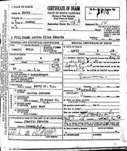
| Birth | : | 16 Mar 1823 Galivants Ferry, Horry County, South Carolina, USA |
| Death | : | 1900 Galivants Ferry, Horry County, South Carolina, USA |
| Burial | : | Rose Hill Cemetery, Berrien Springs, Berrien County, USA |
| Coordinate | : | 41.9331017, -86.3403015 |
| Plot | : | Unknown |
| Inscription | : | Celia C. Floyd 1823-1900. She shares a stone with her husband (on the back). |
| Description | : | Her full name was Celia C. Floyd Floyd Johnson Jolly Watts. The 'C' initial in her middle name may be for Caroline as she named one of her daughters Celia Caroline. She was named, in part, for her Aunt Celia Ann Floyd Johnson 1784-1819 that was her father's (Pugh Floyd) sister . Celia was married a total of 4 times in her life & outlived 3 husbands. Celia's name/dates appear on the back of her 2nd husband's VA tombstone, (A. Warren Johnson) located beside their daughter, Caroline Johnson Edwards at Zion Cemetery. Stone placed by... Read More |
frequently asked questions (FAQ):
-
Where is Celia C. Watts's memorial?
Celia C. Watts's memorial is located at: Rose Hill Cemetery, Berrien Springs, Berrien County, USA.
-
When did Celia C. Watts death?
Celia C. Watts death on 1900 in Galivants Ferry, Horry County, South Carolina, USA
-
Where are the coordinates of the Celia C. Watts's memorial?
Latitude: 41.9331017
Longitude: -86.3403015
Family Members:
Parent

Spouse
Siblings
Children
Flowers:


Nearby Cemetories:
1. Rose Hill Cemetery
Berrien Springs, Berrien County, USA
Coordinate: 41.9331017, -86.3403015
2. Long Lake Cemetery
Berrien Springs, Berrien County, USA
Coordinate: 41.9185982, -86.3125000
3. Berrien County Poor Farm Cemetery
Berrien Springs, Berrien County, USA
Coordinate: 41.9539700, -86.3028900
4. Burke Cemetery
Berrien Springs, Berrien County, USA
Coordinate: 41.9216995, -86.3974991
5. Union Cemetery
Berrien Center, Berrien County, USA
Coordinate: 41.9299431, -86.2727356
6. Colvin Cemetery
Buchanan, Berrien County, USA
Coordinate: 41.8986110, -86.3944440
7. Oak Grove Cemetery
Oronoko, Berrien County, USA
Coordinate: 41.9241982, -86.4122009
8. Maple Grove Cemetery
Eau Claire, Berrien County, USA
Coordinate: 41.9719009, -86.2872009
9. Caldwell Cemetery
Eau Claire, Berrien County, USA
Coordinate: 41.9860992, -86.2861023
10. Sherwood Cemetery
Buchanan, Berrien County, USA
Coordinate: 41.8669440, -86.3636110
11. Lett Cemetery
Sodus, Berrien County, USA
Coordinate: 42.0038890, -86.3447220
12. Salem Cemetery
Oronoko Township, Berrien County, USA
Coordinate: 41.9644012, -86.4278030
13. Morris Chapel Cemetery
Niles, Berrien County, USA
Coordinate: 41.9063880, -86.2463880
14. Benton Cemetery
Niles, Berrien County, USA
Coordinate: 41.8542190, -86.3501790
15. Feather Cemetery
Hinchman, Berrien County, USA
Coordinate: 41.9720955, -86.4356689
16. Mount Pleasant Cemetery
Sodus Township, Berrien County, USA
Coordinate: 42.0194016, -86.3581009
17. Robert Farry Cemetery
Eau Claire, Berrien County, USA
Coordinate: 42.0002778, -86.2619444
18. Hinman Cemetery
Baroda Township, Berrien County, USA
Coordinate: 41.9272003, -86.4597015
19. Boyle Cemetery
Oronoko, Berrien County, USA
Coordinate: 41.9013889, -86.4527778
20. Johnson Cemetery
Niles, Berrien County, USA
Coordinate: 41.8594440, -86.2691660
21. Harrah Road Cemetery
Niles, Berrien County, USA
Coordinate: 41.8425000, -86.3058333
22. Rodgers Cemetery
Pokagon, Cass County, USA
Coordinate: 41.9169365, -86.2149947
23. Franklin Cemetery
Berrien Township, Berrien County, USA
Coordinate: 41.9711110, -86.2236110
24. Virginians Burying Ground
Buchanan, Berrien County, USA
Coordinate: 41.8373070, -86.3694077