

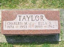
Charles Melburn Taylor
| Birth | : | 13 Jun 1874 Umatilla County, Oregon, USA |
| Death | : | 13 May 1953 |
| Burial | : | Rose Hill Memorial Gardens, Missouri Valley, Harrison County, USA |
| Coordinate | : | 41.5656000, -95.8897000 |
| Plot | : | Section 10, Row 1 |
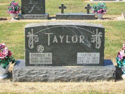
| Description | : | Published in The Rochester News-Sentinel Thursday, May 14, 1953 Charles M. Taylor Charles Melburn TAYLOR, 78, retired farmer, died at 1:30 p.m. Wednesday at his home, 1527 Audubon avenue, Rochester. He had been seriously ill for six weeks. He was born June 13, 1874, in Utila, Ore. to Milton and Sarah DONALDSON TAYLOR. He ws married to Ella FUGATE on April 4, 1896 in Rochester. Practically all of his life was spent in fulton county. Mr.Taylor was a member of the Rochester Christian church. Surviving are his wife, at home; four sons and five daughters, Floyd [TAYLOR], Castleton, N.Y.; Howard and Everett... Read More |
frequently asked questions (FAQ):
-
Where is Charles Melburn Taylor's memorial?
Charles Melburn Taylor's memorial is located at: Rose Hill Memorial Gardens, Missouri Valley, Harrison County, USA.
-
When did Charles Melburn Taylor death?
Charles Melburn Taylor death on 13 May 1953 in
-
Where are the coordinates of the Charles Melburn Taylor's memorial?
Latitude: 41.5656000
Longitude: -95.8897000
Family Members:
Parent
Spouse
Siblings
Children

Flowers:


Nearby Cemetories:
1. Rose Hill Memorial Gardens
Missouri Valley, Harrison County, USA
Coordinate: 41.5656000, -95.8897000
2. Mount Carmel Cemetery
Missouri Valley, Harrison County, USA
Coordinate: 41.5675011, -95.8897018
3. Champan Frazier Cemetery
Harrison County, USA
Coordinate: 41.5773500, -95.8933500
4. Hurleys Evergreen Cemetery
Harrison County, USA
Coordinate: 41.5700989, -95.8618698
5. Frazier Cemetery
Missouri Valley, Harrison County, USA
Coordinate: 41.5932999, -95.8375015
6. Oak Grove Cemetery
Missouri Valley, Harrison County, USA
Coordinate: 41.5167007, -95.8649979
7. Calhoun Cemetery
Calhoun, Harrison County, USA
Coordinate: 41.6391983, -95.8938980
8. Branson Cemetery
Loveland, Pottawattamie County, USA
Coordinate: 41.4846992, -95.8606033
9. Linnwood Cemetery
Harrison County, USA
Coordinate: 41.5589200, -95.7502100
10. Crook Cemetery
Honey Creek, Pottawattamie County, USA
Coordinate: 41.4581330, -95.8737000
11. Saint Bridgets Cemetery
Honey Creek, Pottawattamie County, USA
Coordinate: 41.4664001, -95.8289032
12. Logan Cemetery
Logan, Harrison County, USA
Coordinate: 41.6487579, -95.7843170
13. Harris Grove Cemetery
Beebeetown, Harrison County, USA
Coordinate: 41.5782928, -95.7262192
14. Magnolia Cemetery
Magnolia, Harrison County, USA
Coordinate: 41.6903000, -95.8799973
15. Allen Cemetery
Pottawattamie County, USA
Coordinate: 41.4427986, -95.8550034
16. Saint Bridgets Cemetery
Magnolia, Harrison County, USA
Coordinate: 41.6915660, -95.8812480
17. Grange Cemetery
Honey Creek, Pottawattamie County, USA
Coordinate: 41.4446678, -95.8034668
18. Hauger-Rumbaugh Cemetery
Modale, Harrison County, USA
Coordinate: 41.6388797, -96.0502906
19. Silver Hill Cemetery
Harrison County, USA
Coordinate: 41.6897011, -95.7919006
20. Reels Cemetery
Crescent, Pottawattamie County, USA
Coordinate: 41.4234100, -95.8321700
21. Yutesler Cemetery
Harrison County, USA
Coordinate: 41.6684000, -96.0373000
22. Fort Calhoun Cemetery
Fort Calhoun, Washington County, USA
Coordinate: 41.4581375, -96.0352020
23. Bethel Cemetery
Logan, Harrison County, USA
Coordinate: 41.6239014, -95.6999969
24. William C McIntosh Cemetery
Crescent, Pottawattamie County, USA
Coordinate: 41.4088745, -95.8477097