

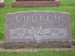
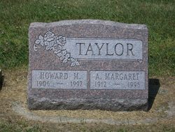
Elsie E Taylor Church
| Birth | : | 9 Jan 1897 |
| Death | : | 19 Feb 1967 |
| Burial | : | Rose Hill Memorial Gardens, Missouri Valley, Harrison County, USA |
| Coordinate | : | 41.5656000, -95.8897000 |
| Plot | : | Section 10, Row 7 |
| Description | : | Published in The Rochester Sentinel Monday, February 20, 1967 Elsie E. Church Mrs. Elsie E. CHURCH, 70, 1527 College avenue, died at 1 p.m. Sunday at her home following an illness of one year. Born Jan. 9, 1897 in Fulton county, she had resided all her life in this county. She was the daughter of Charles and Ella FUGATE TAYLOR. She was married Sept. 5, 1917 in Rochester to Jesse CHURCH, who died April 16, 1963. She was a member of the First Christian church and belonged to Evergreen Rebekah Lodge 57 for over 50 years. She was a former member of the Green... Read More |
frequently asked questions (FAQ):
-
Where is Elsie E Taylor Church's memorial?
Elsie E Taylor Church's memorial is located at: Rose Hill Memorial Gardens, Missouri Valley, Harrison County, USA.
-
When did Elsie E Taylor Church death?
Elsie E Taylor Church death on 19 Feb 1967 in
-
Where are the coordinates of the Elsie E Taylor Church's memorial?
Latitude: 41.5656000
Longitude: -95.8897000
Family Members:
Parent

Spouse
Siblings
Children

Flowers:


Nearby Cemetories:
1. Rose Hill Memorial Gardens
Missouri Valley, Harrison County, USA
Coordinate: 41.5656000, -95.8897000
2. Mount Carmel Cemetery
Missouri Valley, Harrison County, USA
Coordinate: 41.5675011, -95.8897018
3. Champan Frazier Cemetery
Harrison County, USA
Coordinate: 41.5773500, -95.8933500
4. Hurleys Evergreen Cemetery
Harrison County, USA
Coordinate: 41.5700989, -95.8618698
5. Frazier Cemetery
Missouri Valley, Harrison County, USA
Coordinate: 41.5932999, -95.8375015
6. Oak Grove Cemetery
Missouri Valley, Harrison County, USA
Coordinate: 41.5167007, -95.8649979
7. Calhoun Cemetery
Calhoun, Harrison County, USA
Coordinate: 41.6391983, -95.8938980
8. Branson Cemetery
Loveland, Pottawattamie County, USA
Coordinate: 41.4846992, -95.8606033
9. Linnwood Cemetery
Harrison County, USA
Coordinate: 41.5589200, -95.7502100
10. Crook Cemetery
Honey Creek, Pottawattamie County, USA
Coordinate: 41.4581330, -95.8737000
11. Saint Bridgets Cemetery
Honey Creek, Pottawattamie County, USA
Coordinate: 41.4664001, -95.8289032
12. Logan Cemetery
Logan, Harrison County, USA
Coordinate: 41.6487579, -95.7843170
13. Harris Grove Cemetery
Beebeetown, Harrison County, USA
Coordinate: 41.5782928, -95.7262192
14. Magnolia Cemetery
Magnolia, Harrison County, USA
Coordinate: 41.6903000, -95.8799973
15. Allen Cemetery
Pottawattamie County, USA
Coordinate: 41.4427986, -95.8550034
16. Saint Bridgets Cemetery
Magnolia, Harrison County, USA
Coordinate: 41.6915660, -95.8812480
17. Grange Cemetery
Honey Creek, Pottawattamie County, USA
Coordinate: 41.4446678, -95.8034668
18. Hauger-Rumbaugh Cemetery
Modale, Harrison County, USA
Coordinate: 41.6388797, -96.0502906
19. Silver Hill Cemetery
Harrison County, USA
Coordinate: 41.6897011, -95.7919006
20. Reels Cemetery
Crescent, Pottawattamie County, USA
Coordinate: 41.4234100, -95.8321700
21. Yutesler Cemetery
Harrison County, USA
Coordinate: 41.6684000, -96.0373000
22. Fort Calhoun Cemetery
Fort Calhoun, Washington County, USA
Coordinate: 41.4581375, -96.0352020
23. Bethel Cemetery
Logan, Harrison County, USA
Coordinate: 41.6239014, -95.6999969
24. William C McIntosh Cemetery
Crescent, Pottawattamie County, USA
Coordinate: 41.4088745, -95.8477097