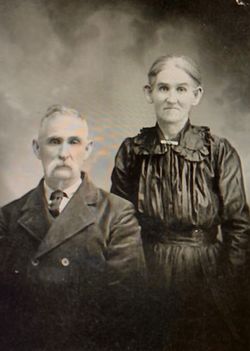
| Birth | : | 13 Jan 1853 Virginia, USA |
| Death | : | 22 Feb 1928 Hughesville, Pettis County, Missouri, USA |
| Burial | : | LaMonte Cemetery, La Monte, Pettis County, USA |
| Coordinate | : | 38.7821999, -93.4319000 |
| Description | : | Son of Ruben DeHaven and Margaret Ann Gill. Married to Arcus Cleopatra Yokley on 16 Feb 1882 in Pettis County, Missouri. Buried on 24 Feb 1928. Click here for his death certificate. (Informant: Maude Davis; Hughesville, Mo.) Note: The birth year (1843) on his death certificate is wrong, but his age is correct. He can't be 75 if he was born in 1843 and died in 1928; he would be 85. Age in U.S. Census records: 1860 7 (est. b. 1853) 1870 14 (est. b. 1856) 1880 28 (est. b. 1852) 1900 47 (b. Jan 1853) 1910 57 (est. b. 1853) 1920 66 (est.... Read More |
frequently asked questions (FAQ):
-
Where is Charles West DeHaven's memorial?
Charles West DeHaven's memorial is located at: LaMonte Cemetery, La Monte, Pettis County, USA.
-
When did Charles West DeHaven death?
Charles West DeHaven death on 22 Feb 1928 in Hughesville, Pettis County, Missouri, USA
-
Where are the coordinates of the Charles West DeHaven's memorial?
Latitude: 38.7821999
Longitude: -93.4319000
Family Members:
Parent
Spouse
Siblings
Children
Flowers:
Nearby Cemetories:
1. LaMonte Cemetery
La Monte, Pettis County, USA
Coordinate: 38.7821999, -93.4319000
2. Moore Family Cemetery
La Monte, Pettis County, USA
Coordinate: 38.8034444, -93.4769722
3. Craighead Cemetery
La Monte, Pettis County, USA
Coordinate: 38.7350006, -93.4124985
4. County Line Cemetery
Blackwater Township, Pettis County, USA
Coordinate: 38.8394012, -93.4644012
5. Prairie Chapel Presbyterian Cemetery
Dresden, Pettis County, USA
Coordinate: 38.8050003, -93.3553009
6. Southers Cemetery
Knob Noster, Johnson County, USA
Coordinate: 38.7967410, -93.5218050
7. Bethel Cemetery
La Monte, Pettis County, USA
Coordinate: 38.7135200, -93.4611300
8. Bethel Union Church Cemetery
Pettis County, USA
Coordinate: 38.7132988, -93.4606018
9. Botts Cemetery
Pettis County, USA
Coordinate: 38.7118988, -93.4019012
10. Rabourn Cemetery
La Monte, Pettis County, USA
Coordinate: 38.7078018, -93.4424973
11. Knob Noster Cemetery
Knob Noster, Johnson County, USA
Coordinate: 38.7655945, -93.5354004
12. North Dresden Cemetery
Dresden, Pettis County, USA
Coordinate: 38.7469600, -93.3352400
13. Dresden Cemetery
Dresden, Pettis County, USA
Coordinate: 38.7468987, -93.3349991
14. Saint Joseph Cemetery
Knob Noster, Johnson County, USA
Coordinate: 38.7599983, -93.5558014
15. Gowin Cemetery
Dunksburg, Johnson County, USA
Coordinate: 38.8747550, -93.4994240
16. Blackwater Chapel Cemetery
Houstonia, Pettis County, USA
Coordinate: 38.8908000, -93.4661600
17. Knaus Cemetery
Johnson County, USA
Coordinate: 38.7957993, -93.5755997
18. Hocker Cemetery
Knob Noster, Johnson County, USA
Coordinate: 38.8567009, -93.5413971
19. Old Hickory Point Cemetery
Pettis County, USA
Coordinate: 38.6652985, -93.4693985
20. Mount Zion Cemetery
Dunksburg, Johnson County, USA
Coordinate: 38.8913900, -93.4975490
21. Camp Branch Baptist Church Cemetery
Sedalia, Pettis County, USA
Coordinate: 38.6731900, -93.3589900
22. Rothwell Cemetery
Johnson County, USA
Coordinate: 38.8711010, -93.5410000
23. David Thomson Cemetery
Georgetown, Pettis County, USA
Coordinate: 38.7799500, -93.2723500
24. Immanuel Lutheran Cemetery
Knob Noster, Johnson County, USA
Coordinate: 38.8275700, -93.5812000


