
| Memorials | : | 7 |
| Location | : | Dresden, Pettis County, USA |
| Coordinate | : | 38.8050003, -93.3553009 |
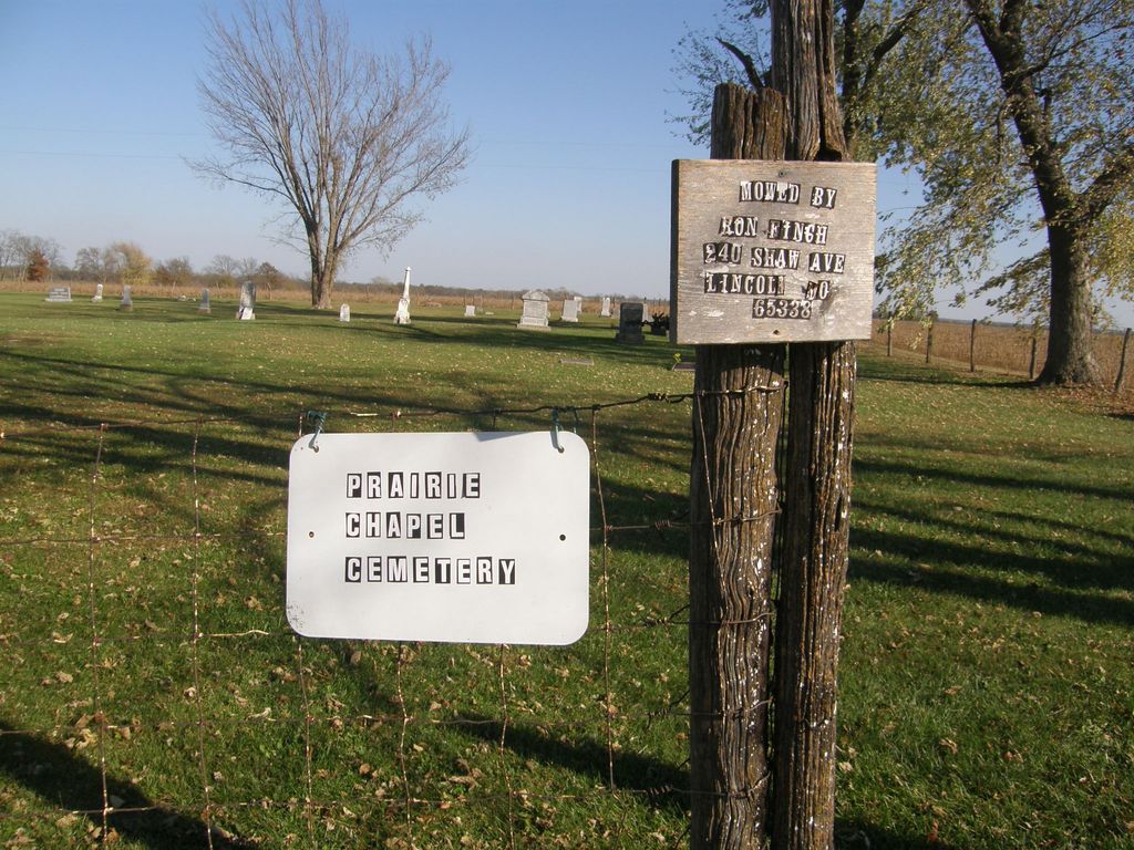
| Description | : | Located four miles northwest of Dresden, and should not be confused with the tiny Prairie Chapel Methodist Cemetery in south Pettis County near Ionia. Marked "Prairie Hill" on geo survey maps and some transcriptions, but listed as Prairie Chapel in the 1882 Pettis County History and on later Missouri death certificates of burials. |
frequently asked questions (FAQ):
-
Where is Prairie Chapel Presbyterian Cemetery?
Prairie Chapel Presbyterian Cemetery is located at Dresden, Pettis County ,Missouri ,USA.
-
Prairie Chapel Presbyterian Cemetery cemetery's updated grave count on graveviews.com?
5 memorials
-
Where are the coordinates of the Prairie Chapel Presbyterian Cemetery?
Latitude: 38.8050003
Longitude: -93.3553009
Nearby Cemetories:
1. North Dresden Cemetery
Dresden, Pettis County, USA
Coordinate: 38.7469600, -93.3352400
2. Dresden Cemetery
Dresden, Pettis County, USA
Coordinate: 38.7468987, -93.3349991
3. LaMonte Cemetery
La Monte, Pettis County, USA
Coordinate: 38.7821999, -93.4319000
4. David Thomson Cemetery
Georgetown, Pettis County, USA
Coordinate: 38.7799500, -93.2723500
5. Forbes-Bouldin Cemetery
Hughesville, Pettis County, USA
Coordinate: 38.7956200, -93.2589500
6. Craighead Cemetery
La Monte, Pettis County, USA
Coordinate: 38.7350006, -93.4124985
7. Forbes-Heard Cemetery
Hughesville, Pettis County, USA
Coordinate: 38.7937100, -93.2470200
8. Houstonia Cemetery
Houstonia, Pettis County, USA
Coordinate: 38.8941994, -93.3531036
9. County Line Cemetery
Blackwater Township, Pettis County, USA
Coordinate: 38.8394012, -93.4644012
10. Moore Family Cemetery
La Monte, Pettis County, USA
Coordinate: 38.8034444, -93.4769722
11. High Point Cemetery
Hughesville, Pettis County, USA
Coordinate: 38.8549995, -93.2506027
12. High Hill Cemetery
Pettis County, USA
Coordinate: 38.8544006, -93.2446976
13. Georgetown Cemetery
Georgetown, Pettis County, USA
Coordinate: 38.7616770, -93.2398460
14. Botts Cemetery
Pettis County, USA
Coordinate: 38.7118988, -93.4019012
15. Mount Herman Cemetery
Cedar Township, Pettis County, USA
Coordinate: 38.7748700, -93.2198700
16. Shobe Cemetery
Sedalia, Pettis County, USA
Coordinate: 38.6996994, -93.2968979
17. Rabourn Cemetery
La Monte, Pettis County, USA
Coordinate: 38.7078018, -93.4424973
18. Blackwater Chapel Cemetery
Houstonia, Pettis County, USA
Coordinate: 38.8908000, -93.4661600
19. Bethel Union Church Cemetery
Pettis County, USA
Coordinate: 38.7132988, -93.4606018
20. Bethel Cemetery
La Monte, Pettis County, USA
Coordinate: 38.7135200, -93.4611300
21. South Fork Cemetery
Pettis County, USA
Coordinate: 38.9169006, -93.4227982
22. Southers Cemetery
Knob Noster, Johnson County, USA
Coordinate: 38.7967410, -93.5218050
23. Camp Branch Baptist Church Cemetery
Sedalia, Pettis County, USA
Coordinate: 38.6731900, -93.3589900
24. Gowin Cemetery
Dunksburg, Johnson County, USA
Coordinate: 38.8747550, -93.4994240