
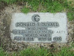
| Birth | : | 28 Sep 1896 Spirit Lake, Dickinson County, Iowa, USA |
| Death | : | 13 Nov 1931 Milford, Dickinson County, Iowa, USA |
| Burial | : | St Everilda Churchyard, Nether Poppleton, York Unitary Authority, England |
| Coordinate | : | 53.9882060, -1.1403710 |
frequently asked questions (FAQ):
-
Where is Charlotte Holcomb DuVall's memorial?
Charlotte Holcomb DuVall's memorial is located at: St Everilda Churchyard, Nether Poppleton, York Unitary Authority, England.
-
When did Charlotte Holcomb DuVall death?
Charlotte Holcomb DuVall death on 13 Nov 1931 in Milford, Dickinson County, Iowa, USA
-
Where are the coordinates of the Charlotte Holcomb DuVall's memorial?
Latitude: 53.9882060
Longitude: -1.1403710
Family Members:
Parent

Spouse
Siblings
Children
Flowers:


Nearby Cemetories:
1. St Everilda Churchyard
Nether Poppleton, York Unitary Authority, England
Coordinate: 53.9882060, -1.1403710
2. All Saints Churchyard
Upper Poppleton, York Unitary Authority, England
Coordinate: 53.9776970, -1.1510780
3. St. Giles' Churchyard
Skelton, York Unitary Authority, England
Coordinate: 54.0019111, -1.1342660
4. Skelton Parish Council Cemetery
Skelton, York Unitary Authority, England
Coordinate: 54.0070970, -1.1150970
5. St Barnabas Church
York, York Unitary Authority, England
Coordinate: 53.9639530, -1.1030490
6. St Stephen Churchyard
Acomb, York Unitary Authority, England
Coordinate: 53.9558840, -1.1289100
7. Moorlands Nature Reserve
Skelton, York Unitary Authority, England
Coordinate: 54.0226680, -1.1201180
8. Holy Evangelists Churchyard
Shipton, Hambleton District, England
Coordinate: 54.0234400, -1.1572300
9. St John's the Baptist Church
Hessay, York Unitary Authority, England
Coordinate: 53.9767283, -1.2027246
10. St Olave Churchyard
York, York Unitary Authority, England
Coordinate: 53.9622570, -1.0891560
11. Abbey of St Mary (defunct)
York, York Unitary Authority, England
Coordinate: 53.9620290, -1.0883600
12. St Giles Churchyard
York, York Unitary Authority, England
Coordinate: 53.9640010, -1.0843930
13. York Cholera Burial Ground
York, York Unitary Authority, England
Coordinate: 53.9586930, -1.0908420
14. Blackfriars Abbey Church (Defunct)
York, York Unitary Authority, England
Coordinate: 53.9594100, -1.0880900
15. Lendal Congregational Chapel
York, York Unitary Authority, England
Coordinate: 53.9606360, -1.0860970
16. St Wilfred Churchyard
York, York Unitary Authority, England
Coordinate: 53.9610550, -1.0848990
17. Augustinian Friary, York (Nonextant)
York, York Unitary Authority, England
Coordinate: 53.9601683, -1.0860521
18. St Michael le Belfrey Churchyard
York, York Unitary Authority, England
Coordinate: 53.9618620, -1.0829730
19. St Helen Churchyard
York, York Unitary Authority, England
Coordinate: 53.9603030, -1.0841970
20. York Minster
York, York Unitary Authority, England
Coordinate: 53.9619440, -1.0819440
21. All Saints North Street Churchyard
York, York Unitary Authority, England
Coordinate: 53.9584400, -1.0862400
22. Holy Trinity Priory Churchyard
York, York Unitary Authority, England
Coordinate: 53.9565340, -1.0892450
23. St Martin le Grand Churchyard
York, York Unitary Authority, England
Coordinate: 53.9593870, -1.0843800
24. St Mary's Convent - The Bar Convent
York, York Unitary Authority, England
Coordinate: 53.9552520, -1.0911020