
| Birth | : | 20 Feb 1862 Preston, Jackson County, Iowa, USA |
| Death | : | 19 Jan 1938 Underwood, Pottawattamie County, Iowa, USA |
| Burial | : | H G Fisher Cemetery, Underwood, Pottawattamie County, USA |
| Coordinate | : | 41.3838997, -95.6889038 |
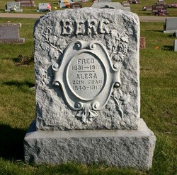
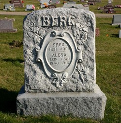
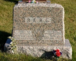
| Description | : | Evangelical Lutheran Church Name: Johann Meyer Gender: Male Record Type: Marriage Marriage Date: 12 Feb 1882 Marriage Place: Elliott, Illinois, USA Spouse: Christine Berg Church Name: Salem Church Location: Spragueville, Iowa IA death certificate Christina Berg Meyer father-Fred Berg b. Germany d. stomach cancer Fisher Cemeetery |
frequently asked questions (FAQ):
-
Where is Christina Berg Meyer's memorial?
Christina Berg Meyer's memorial is located at: H G Fisher Cemetery, Underwood, Pottawattamie County, USA.
-
When did Christina Berg Meyer death?
Christina Berg Meyer death on 19 Jan 1938 in Underwood, Pottawattamie County, Iowa, USA
-
Where are the coordinates of the Christina Berg Meyer's memorial?
Latitude: 41.3838997
Longitude: -95.6889038
Family Members:
Parent
Spouse

Siblings
Children
Flowers:


Nearby Cemetories:
1. H G Fisher Cemetery
Underwood, Pottawattamie County, USA
Coordinate: 41.3838997, -95.6889038
2. Castor Cemetery
Underwood, Pottawattamie County, USA
Coordinate: 41.4127040, -95.6887490
3. Downsville Cemetery
Pottawattamie County, USA
Coordinate: 41.3502998, -95.7039032
4. Saint Columbanus Cemetery
Weston, Pottawattamie County, USA
Coordinate: 41.3429440, -95.7435260
5. Pottawattamie County Home Cemetery
McClelland, Pottawattamie County, USA
Coordinate: 41.3269400, -95.6691738
6. Saint Pauls Lutheran Cemetery
Neola, Pottawattamie County, USA
Coordinate: 41.4337000, -95.7607000
7. Jones - Williams Cemetery
Pottawattamie County, USA
Coordinate: 41.3761000, -95.5846000
8. Hazel Dell Cemetery
Council Bluffs, Pottawattamie County, USA
Coordinate: 41.3489723, -95.7939911
9. Saint Patricks Cemetery
Neola, Pottawattamie County, USA
Coordinate: 41.4581300, -95.6183600
10. Neola Township Cemetery
Neola, Pottawattamie County, USA
Coordinate: 41.4591400, -95.6183800
11. Hardin Township Cemetery
McClelland, Pottawattamie County, USA
Coordinate: 41.2949982, -95.6513977
12. Gregg Cemetery
Weston, Pottawattamie County, USA
Coordinate: 41.3330000, -95.7931000
13. Grange Cemetery
Honey Creek, Pottawattamie County, USA
Coordinate: 41.4446678, -95.8034668
14. Reels Cemetery
Crescent, Pottawattamie County, USA
Coordinate: 41.4234100, -95.8321700
15. Garner Cemetery
Council Bluffs, Pottawattamie County, USA
Coordinate: 41.2956161, -95.8001709
16. William C McIntosh Cemetery
Crescent, Pottawattamie County, USA
Coordinate: 41.4088745, -95.8477097
17. Evans Cemetery
Crescent, Pottawattamie County, USA
Coordinate: 41.3255997, -95.8368988
18. Crescent Cemetery
Crescent, Pottawattamie County, USA
Coordinate: 41.3664894, -95.8566208
19. Saint Bridgets Cemetery
Honey Creek, Pottawattamie County, USA
Coordinate: 41.4664001, -95.8289032
20. Allen Cemetery
Pottawattamie County, USA
Coordinate: 41.4427986, -95.8550034
21. Minden Township Cemetery
Minden, Pottawattamie County, USA
Coordinate: 41.4763908, -95.5444412
22. Fairview Pioneer Cemetery
Treynor, Pottawattamie County, USA
Coordinate: 41.2812843, -95.5555267
23. Silver Valley Cemetery
Hancock, Pottawattamie County, USA
Coordinate: 41.4042015, -95.4969025
24. Stoker-Graybill Cemetery
Council Bluffs, Pottawattamie County, USA
Coordinate: 41.2532620, -95.7751770