

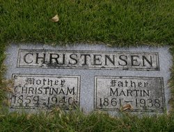
Christina Marie Sorensen Christensen
| Birth | : | 14 Feb 1859 Denmark |
| Death | : | 27 Apr 1940 Council Bluffs, Pottawattamie County, Iowa, USA |
| Burial | : | Cedar Lawn Cemetery, Council Bluffs, Pottawattamie County, USA |
| Coordinate | : | 41.2694016, -95.8182983 |
| Description | : | At time of her death, she was living in Manawa with her youngest daughter, Nora, and husband Art Larsen. Cause of death was Carcinoma of the caecum (large intestine)l. Other condition was senility. She died at home. Nora did not list her mother's parents on the death certificate. |
frequently asked questions (FAQ):
-
Where is Christina Marie Sorensen Christensen's memorial?
Christina Marie Sorensen Christensen's memorial is located at: Cedar Lawn Cemetery, Council Bluffs, Pottawattamie County, USA.
-
When did Christina Marie Sorensen Christensen death?
Christina Marie Sorensen Christensen death on 27 Apr 1940 in Council Bluffs, Pottawattamie County, Iowa, USA
-
Where are the coordinates of the Christina Marie Sorensen Christensen's memorial?
Latitude: 41.2694016
Longitude: -95.8182983
Family Members:
Spouse
Children
Flowers:


Nearby Cemetories:
1. Cedar Lawn Cemetery
Council Bluffs, Pottawattamie County, USA
Coordinate: 41.2694016, -95.8182983
2. Oak Hill Cemetery
Council Bluffs, Pottawattamie County, USA
Coordinate: 41.2700900, -95.8226400
3. Saint Joseph Cemetery
Council Bluffs, Pottawattamie County, USA
Coordinate: 41.2722015, -95.8208008
4. Bikhor Cholim Cemetery
Council Bluffs, Pottawattamie County, USA
Coordinate: 41.2703670, -95.8229350
5. Green Valley Cemetery
Council Bluffs, Pottawattamie County, USA
Coordinate: 41.2743988, -95.8225021
6. Walnut Hill Cemetery
Council Bluffs, Pottawattamie County, USA
Coordinate: 41.2719002, -95.8255997
7. Ridgewood Cemetery
Council Bluffs, Pottawattamie County, USA
Coordinate: 41.2694016, -95.8272018
8. Memorial Park Cemetery
Council Bluffs, Pottawattamie County, USA
Coordinate: 41.2644005, -95.8261032
9. Clark Cemetery
Pottawattamie County, USA
Coordinate: 41.2551610, -95.8223390
10. Fairview Cemetery
Council Bluffs, Pottawattamie County, USA
Coordinate: 41.2703018, -95.8480988
11. Garner Cemetery
Council Bluffs, Pottawattamie County, USA
Coordinate: 41.2956161, -95.8001709
12. Stoker-Graybill Cemetery
Council Bluffs, Pottawattamie County, USA
Coordinate: 41.2532620, -95.7751770
13. Maple Grove Cemetery
Council Bluffs, Pottawattamie County, USA
Coordinate: 41.2265560, -95.8187100
14. Evans Cemetery
Crescent, Pottawattamie County, USA
Coordinate: 41.3255997, -95.8368988
15. Lewis Township Cemetery
Council Bluffs, Pottawattamie County, USA
Coordinate: 41.2117004, -95.7938995
16. Gregg Cemetery
Weston, Pottawattamie County, USA
Coordinate: 41.3330000, -95.7931000
17. Council Point Cemetery
Council Bluffs, Pottawattamie County, USA
Coordinate: 41.2110830, -95.8788610
18. Hazel Dell Cemetery
Council Bluffs, Pottawattamie County, USA
Coordinate: 41.3489723, -95.7939911
19. Trinity Cathedral Columbarium
Omaha, Douglas County, USA
Coordinate: 41.2603900, -95.9393660
20. Saint Columbanus Cemetery
Weston, Pottawattamie County, USA
Coordinate: 41.3429440, -95.7435260
21. Crescent Cemetery
Crescent, Pottawattamie County, USA
Coordinate: 41.3664894, -95.8566208
22. Prospect Hill Cemetery
Omaha, Douglas County, USA
Coordinate: 41.2780991, -95.9593964
23. Saint Pauls Evangelical Country Church Cemetery
Dumfries, Pottawattamie County, USA
Coordinate: 41.1748352, -95.7492371
24. First Central Congregational Columbarium
Omaha, Douglas County, USA
Coordinate: 41.2563456, -95.9658365