

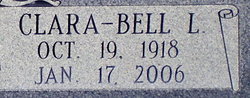
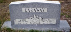
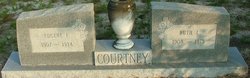
Clara Bell Locklair Caraway
| Birth | : | 19 Oct 1918 |
| Death | : | 17 Jan 2006 |
| Burial | : | St. Peter and St. Paul Churchyard, Shiplake, South Oxfordshire District, England |
| Coordinate | : | 51.4980750, -0.8963940 |
| Description | : | COWARD — Mrs. Clara Bell Locklair Caraway, 88, wife of the late George Caraway, died Tuesday, Jan. 17, 2006, in a Florence hospital after an illness. Mrs. Caraway was born in Timmonsville, a daughter of the late Adolph and Maggie Conners Locklair, and she was a homemaker. She was a member of St. Paul United Methodist Church, where she was a devoted church worker, a former Sunday school teacher and served as organist and pianist of the church. She was a wonderful mother, grandmother, great-grandmother and mother-in-law. Survivors include four sons, James (Jeanette) Caraway and George "Billy" Caraway, both of Coward, Carl... Read More |
frequently asked questions (FAQ):
-
Where is Clara Bell Locklair Caraway's memorial?
Clara Bell Locklair Caraway's memorial is located at: St. Peter and St. Paul Churchyard, Shiplake, South Oxfordshire District, England.
-
When did Clara Bell Locklair Caraway death?
Clara Bell Locklair Caraway death on 17 Jan 2006 in
-
Where are the coordinates of the Clara Bell Locklair Caraway's memorial?
Latitude: 51.4980750
Longitude: -0.8963940
Family Members:
Parent

Spouse
Siblings

Children
Flowers:


Nearby Cemetories:
1. St. Peter and St. Paul Churchyard
Shiplake, South Oxfordshire District, England
Coordinate: 51.4980750, -0.8963940
2. St. Mary's Churchyard
Wargrave, Wokingham Borough, England
Coordinate: 51.4998329, -0.8735808
3. St Margaret's Churchyard
Harpsden, South Oxfordshire District, England
Coordinate: 51.5219160, -0.9012270
4. St. Andrew's Churchyard
Sonning, Wokingham Borough, England
Coordinate: 51.4740300, -0.9131640
5. St Mary's Churchyard
Twyford, Wokingham Borough, England
Coordinate: 51.4763850, -0.8673190
6. All Saints Churchyard
Dunsden Green, South Oxfordshire District, England
Coordinate: 51.4917730, -0.9461650
7. Holy Trinity Churchyard
Henley-on-Thames, South Oxfordshire District, England
Coordinate: 51.5338500, -0.9066600
8. Christ Church
Henley-on-Thames, South Oxfordshire District, England
Coordinate: 51.5347880, -0.9032820
9. St. Mary the Virgin Churchyard
Henley-on-Thames, South Oxfordshire District, England
Coordinate: 51.5377790, -0.9017520
10. Reading Cemetery and Crematorium
Caversham, Reading Borough, England
Coordinate: 51.4737690, -0.9546570
11. St. Nicholas' Churchyard
Rotherfield Greys, South Oxfordshire District, England
Coordinate: 51.5351017, -0.9541395
12. St. Peter's Churchyard
Knowl Hill, Windsor and Maidenhead Royal Borough, England
Coordinate: 51.5093351, -0.8126725
13. Caversham Cemetery
Caversham, Reading Borough, England
Coordinate: 51.4745850, -0.9758020
14. Reading Cemetery
Reading, Reading Borough, England
Coordinate: 51.4529450, -0.9480160
15. All Saints Churchyard
Rotherfield Peppard, South Oxfordshire District, England
Coordinate: 51.5280531, -0.9725009
16. St Lawrence Churchyard
Waltham St Lawrence, Windsor and Maidenhead Royal Borough, England
Coordinate: 51.4856000, -0.8066600
17. Mays Lane Burial Ground
Earley, Wokingham Borough, England
Coordinate: 51.4431680, -0.9240020
18. Earley St Peter Churchyard
Earley, Wokingham Borough, England
Coordinate: 51.4434820, -0.9290850
19. Reading Prison Cemetery
Reading, Reading Borough, England
Coordinate: 51.4564910, -0.9641120
20. Henley-on-Thames Cemetery
Henley-on-Thames, South Oxfordshire District, England
Coordinate: 51.5543570, -0.9271320
21. Reading Abbey Ruins
Reading, Reading Borough, England
Coordinate: 51.4563710, -0.9651130
22. St. Peter's Churchyard
Caversham, Reading Borough, England
Coordinate: 51.4686597, -0.9807669
23. St. Laurence Churchyard
Reading, Reading Borough, England
Coordinate: 51.4567474, -0.9686236
24. Kidmore End Cemetery
Kidmore End, South Oxfordshire District, England
Coordinate: 51.5071600, -0.9942160