

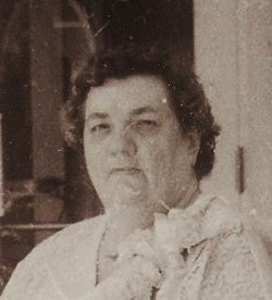
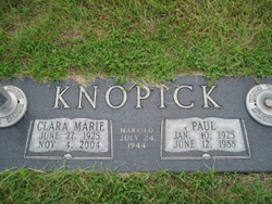
Clara Marie Kiuntke Knopick
| Birth | : | 27 Jun 1925 Creston, Platte County, Nebraska, USA |
| Death | : | 4 Nov 2000 Schuyler, Colfax County, Nebraska, USA |
| Burial | : | Droylsden Cemetery, Droylsden, Metropolitan Borough of Tameside, England |
| Coordinate | : | 53.4849400, -2.1529696 |
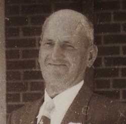
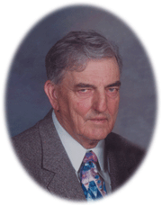
| Description | : | Daughter of Walter & R.ose (Schacher) Kiuntke. She attended country school and graduated from Kramer High School in 1944. On July 24, 1944 she was united in marriage to Paul Knopick at St. Lukes's Congregational Church in Columbus. Clara worked the night shift at the Columbus Manor for 19 years. She was a member of St. Luke's Congregational Church and active in the PTA, Cub Scouts and Webelos. Clara enjoyed camping with her husband, embroidery and ceramics. She is survived by: Daughter: Diane (Leander) Bower of Columbus, NE Son: Paul (Rebecca) Knopick of Columbus, NE Son: Kevin (Renne) Knopick of Columbus, NE Daughter:... Read More |
frequently asked questions (FAQ):
-
Where is Clara Marie Kiuntke Knopick's memorial?
Clara Marie Kiuntke Knopick's memorial is located at: Droylsden Cemetery, Droylsden, Metropolitan Borough of Tameside, England.
-
When did Clara Marie Kiuntke Knopick death?
Clara Marie Kiuntke Knopick death on 4 Nov 2000 in Schuyler, Colfax County, Nebraska, USA
-
Where are the coordinates of the Clara Marie Kiuntke Knopick's memorial?
Latitude: 53.4849400
Longitude: -2.1529696
Family Members:
Parent
Spouse
Siblings


Children
Flowers:


Nearby Cemetories:
1. Droylsden Cemetery
Droylsden, Metropolitan Borough of Tameside, England
Coordinate: 53.4849400, -2.1529696
2. St Cross Churchyard
Clayton, Metropolitan Borough of Manchester, England
Coordinate: 53.4832190, -2.1823530
3. Failsworth Cemetery
Failsworth, Metropolitan Borough of Oldham, England
Coordinate: 53.5048760, -2.1537550
4. Failsworth Jewish Cemetery
Failsworth, Metropolitan Borough of Oldham, England
Coordinate: 53.5050270, -2.1534220
5. All Saints Churchyard
Newton Heath, Metropolitan Borough of Manchester, England
Coordinate: 53.5002260, -2.1777970
6. Saint Stephens Churchyard
Audenshaw, Metropolitan Borough of Tameside, England
Coordinate: 53.4753000, -2.1151700
7. St. Peter's Churchyard
Ashton-Under-Lyne, Metropolitan Borough of Tameside, England
Coordinate: 53.4839340, -2.1054690
8. Philips Park Cemetery
Miles Platting, Metropolitan Borough of Manchester, England
Coordinate: 53.4898020, -2.2007400
9. Gorton Cemetery
Manchester, Metropolitan Borough of Manchester, England
Coordinate: 53.4567080, -2.1632580
10. Audenshaw Cemetery
Audenshaw, Metropolitan Borough of Tameside, England
Coordinate: 53.4653300, -2.1101560
11. Oldham Crematorium
Oldham, Metropolitan Borough of Oldham, England
Coordinate: 53.5156810, -2.1332800
12. Christ Church Churchyard
Denton, Metropolitan Borough of Tameside, England
Coordinate: 53.4560270, -2.1218270
13. Hollinwood Cemetery
Oldham, Metropolitan Borough of Oldham, England
Coordinate: 53.5178170, -2.1329170
14. Saint Mary's Churchyard
Moston, Metropolitan Borough of Manchester, England
Coordinate: 53.5181740, -2.1763410
15. St. Joseph's Roman Catholic Churchyard
Moston, Metropolitan Borough of Manchester, England
Coordinate: 53.5149270, -2.1877070
16. Dukinfield Cemetery and Crematorium
Dukinfield, Metropolitan Borough of Tameside, England
Coordinate: 53.4800300, -2.0857150
17. Former Saint Johns Churchyard
Longsight, Metropolitan Borough of Manchester, England
Coordinate: 53.4570760, -2.2025800
18. St Lawrence Church
Denton, Metropolitan Borough of Tameside, England
Coordinate: 53.4520000, -2.1109000
19. All Saints Churchyard
Chorlton-on-Medlock, Metropolitan Borough of Manchester, England
Coordinate: 53.4666670, -2.2166670
20. Manchester General Cemetery
Manchester, Metropolitan Borough of Manchester, England
Coordinate: 53.5062710, -2.2179570
21. St Thomas Churchyard
Ardwick, Metropolitan Borough of Manchester, England
Coordinate: 53.4720000, -2.2248900
22. Christchurch Harpurhey Churchyard
Harpurhey, Metropolitan Borough of Manchester, England
Coordinate: 53.5115100, -2.2134800
23. St. John the Evangelist Churchyard
Hurst, Metropolitan Borough of Tameside, England
Coordinate: 53.5001310, -2.0812490
24. St Elisabeth Church
Reddish, Metropolitan Borough of Stockport, England
Coordinate: 53.4379400, -2.1633950