
| Birth | : | 15 Sep 1940 Columbus, Platte County, Nebraska, USA |
| Death | : | 29 Oct 1996 Council Bluffs, Pottawattamie County, Iowa, USA |
| Burial | : | Saint Pauls Lutheran Cemetery, Neola, Pottawattamie County, USA |
| Coordinate | : | 41.4337000, -95.7607000 |
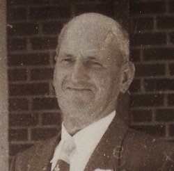
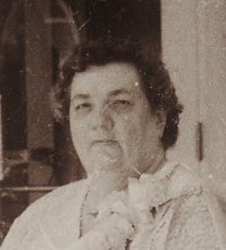
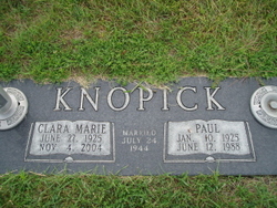
| Description | : | Columbus-Mila Jean Kiuntke, 56, of Council Bluffs, Iowa, died Tuesday, October 29, 1996. Services at St. Paul's United Church of Christ in Council Bluffs with burial at the parish cemetery. Mila was born September 15, 1940, to Walter H. and Rose Kiuntke and was a graduate of Kramer High School of Columbus. She graduated from the University of Omaha Hospital and practiced nursing until 1964. She married Darwin Andersen in 1964 at Columbus. Survivors include her husband; one daughter, Leta Hase of Sioux City, Iowa; two brothers, Walter "Bud" and Norman Kiuntke, both of Columbus; and two sisters, Elsie Bierlie and Clara Knopick,... Read More |
frequently asked questions (FAQ):
-
Where is Mila Jean Kiuntke Andersen's memorial?
Mila Jean Kiuntke Andersen's memorial is located at: Saint Pauls Lutheran Cemetery, Neola, Pottawattamie County, USA.
-
When did Mila Jean Kiuntke Andersen death?
Mila Jean Kiuntke Andersen death on 29 Oct 1996 in Council Bluffs, Pottawattamie County, Iowa, USA
-
Where are the coordinates of the Mila Jean Kiuntke Andersen's memorial?
Latitude: 41.4337000
Longitude: -95.7607000
Family Members:
Parent
Spouse

Siblings


Flowers:


Nearby Cemetories:
1. Saint Pauls Lutheran Cemetery
Neola, Pottawattamie County, USA
Coordinate: 41.4337000, -95.7607000
2. Grange Cemetery
Honey Creek, Pottawattamie County, USA
Coordinate: 41.4446678, -95.8034668
3. Reels Cemetery
Crescent, Pottawattamie County, USA
Coordinate: 41.4234100, -95.8321700
4. Castor Cemetery
Underwood, Pottawattamie County, USA
Coordinate: 41.4127040, -95.6887490
5. Saint Bridgets Cemetery
Honey Creek, Pottawattamie County, USA
Coordinate: 41.4664001, -95.8289032
6. William C McIntosh Cemetery
Crescent, Pottawattamie County, USA
Coordinate: 41.4088745, -95.8477097
7. Allen Cemetery
Pottawattamie County, USA
Coordinate: 41.4427986, -95.8550034
8. H G Fisher Cemetery
Underwood, Pottawattamie County, USA
Coordinate: 41.3838997, -95.6889038
9. Crook Cemetery
Honey Creek, Pottawattamie County, USA
Coordinate: 41.4581330, -95.8737000
10. Hazel Dell Cemetery
Council Bluffs, Pottawattamie County, USA
Coordinate: 41.3489723, -95.7939911
11. Branson Cemetery
Loveland, Pottawattamie County, USA
Coordinate: 41.4846992, -95.8606033
12. Saint Columbanus Cemetery
Weston, Pottawattamie County, USA
Coordinate: 41.3429440, -95.7435260
13. Downsville Cemetery
Pottawattamie County, USA
Coordinate: 41.3502998, -95.7039032
14. Crescent Cemetery
Crescent, Pottawattamie County, USA
Coordinate: 41.3664894, -95.8566208
15. Gregg Cemetery
Weston, Pottawattamie County, USA
Coordinate: 41.3330000, -95.7931000
16. Saint Patricks Cemetery
Neola, Pottawattamie County, USA
Coordinate: 41.4581300, -95.6183600
17. Neola Township Cemetery
Neola, Pottawattamie County, USA
Coordinate: 41.4591400, -95.6183800
18. Oak Grove Cemetery
Missouri Valley, Harrison County, USA
Coordinate: 41.5167007, -95.8649979
19. Evans Cemetery
Crescent, Pottawattamie County, USA
Coordinate: 41.3255997, -95.8368988
20. Linnwood Cemetery
Harrison County, USA
Coordinate: 41.5589200, -95.7502100
21. Pottawattamie County Home Cemetery
McClelland, Pottawattamie County, USA
Coordinate: 41.3269400, -95.6691738
22. Cox Cemetery
Persia, Harrison County, USA
Coordinate: 41.5391998, -95.6418991
23. Garner Cemetery
Council Bluffs, Pottawattamie County, USA
Coordinate: 41.2956161, -95.8001709
24. Jones - Williams Cemetery
Pottawattamie County, USA
Coordinate: 41.3761000, -95.5846000