
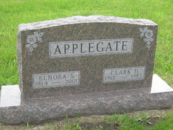
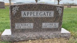
Clark Hammond Applegate
| Birth | : | 6 Apr 1912 Cambridge, Story County, Iowa, USA |
| Death | : | 21 Jun 1982 Woodward, Dallas County, Iowa, USA |
| Burial | : | Yarwell Anglican and Methodist Church, Yarwell, East Northamptonshire Borough, England |
| Coordinate | : | 52.5671280, -0.4216160 |
| Plot | : | North Section, Row 4-3 |
| Description | : | Marriage Record: Name: Clark H Applegate, Male Marriage Date: 20 May 1933, Slater, Iowa, USA Spouse: Elnora Nervig Church Name: Bethlehem Lutheran Church, Slater, Iowa Contributor: Jean Wilson (48841367) • |
frequently asked questions (FAQ):
-
Where is Clark Hammond Applegate's memorial?
Clark Hammond Applegate's memorial is located at: Yarwell Anglican and Methodist Church, Yarwell, East Northamptonshire Borough, England.
-
When did Clark Hammond Applegate death?
Clark Hammond Applegate death on 21 Jun 1982 in Woodward, Dallas County, Iowa, USA
-
Where are the coordinates of the Clark Hammond Applegate's memorial?
Latitude: 52.5671280
Longitude: -0.4216160
Family Members:
Parent

Spouse
Siblings
Children
Flowers:


Nearby Cemetories:
1. Yarwell Anglican and Methodist Church
Yarwell, East Northamptonshire Borough, England
Coordinate: 52.5671280, -0.4216160
2. Nassington and Yarwell Cemetery
Yarwell, East Northamptonshire Borough, England
Coordinate: 52.5682373, -0.4263580
3. St Mary the Virgin Church
Wansford, Huntingdonshire District, England
Coordinate: 52.5805160, -0.4173890
4. Saint Mary the Virgin & All Saints Churchyard
Nassington, East Northamptonshire Borough, England
Coordinate: 52.5530000, -0.4332000
5. St John the Baptist Churchyard
Stibbington, Huntingdonshire District, England
Coordinate: 52.5748920, -0.3926720
6. St. Michael & All Angels
Sutton, Peterborough Unitary Authority, England
Coordinate: 52.5754356, -0.3853515
7. St Remigius Churchyard
Water Newton, Huntingdonshire District, England
Coordinate: 52.5624550, -0.3656390
8. All Saints Churchyard
Elton, Huntingdonshire District, England
Coordinate: 52.5320200, -0.4063200
9. All Saints Churchyard
Wittering, Peterborough Unitary Authority, England
Coordinate: 52.6058600, -0.4421600
10. St Mary the Virgin and All Saints Churchyard
Fotheringhay, East Northamptonshire Borough, England
Coordinate: 52.5258330, -0.4390740
11. Fotheringhay Castle
Fotheringhay, East Northamptonshire Borough, England
Coordinate: 52.5243170, -0.4363420
12. St Mary Churchyard
Woodnewton, East Northamptonshire Borough, England
Coordinate: 52.5392210, -0.4795790
13. St Leonard Churchyard
Apethorpe, East Northamptonshire Borough, England
Coordinate: 52.5495140, -0.4899340
14. St Kyneburgha Churchyard
Castor, Peterborough Unitary Authority, England
Coordinate: 52.5729580, -0.3417630
15. Kings Cliffe Cemetery
Kings Cliffe, East Northamptonshire Borough, England
Coordinate: 52.5605586, -0.5102005
16. St. Michael's Churchyard
Chesterton, Huntingdonshire District, England
Coordinate: 52.5451434, -0.3400366
17. All Saints Churchyard
Kings Cliffe, East Northamptonshire Borough, England
Coordinate: 52.5622450, -0.5160080
18. St. Andrew's Church
Alwalton, Huntingdonshire District, England
Coordinate: 52.5495800, -0.3297610
19. Alwalton Cemetery
Alwalton, Huntingdonshire District, England
Coordinate: 52.5501113, -0.3288831
20. St. Andrew's Churchyard
Ufford, Peterborough Unitary Authority, England
Coordinate: 52.6230210, -0.3864660
21. Saint Mary the Virgin Churchyard
Warmington, East Northamptonshire Borough, England
Coordinate: 52.5064111, -0.4144919
22. St. Mary's Churchyard
Tansor, East Northamptonshire Borough, England
Coordinate: 52.5057500, -0.4493700
23. St. John the Baptist Churchyard
Barnack, Peterborough Unitary Authority, England
Coordinate: 52.6324997, -0.4068000
24. Barnack Bainton Road Cemetery
Barnack, Peterborough Unitary Authority, England
Coordinate: 52.6350291, -0.4069986