
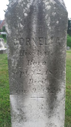
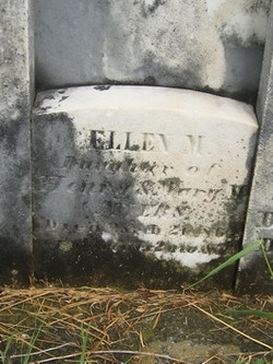
Cornelia Direne Myers Hahn
| Birth | : | 12 Sep 1854 Carroll County, Maryland, USA |
| Death | : | 9 Apr 1920 Hanover, York County, Pennsylvania, USA |
| Burial | : | St. Andrew's Churchyard, Chew Stoke, Bath and North East Somerset Unitary Authority, England |
| Coordinate | : | 51.3548580, -2.6379190 |
| Plot | : | H10-08c |
| Inscription | : | wife |
| Description | : | Mrs. Cornelia D. Hahn, widow of Josiah Hahn, died Friday at the home of her daughter, Mrs. Lester D. Stahl, Hanover, aged 65 years. Death was due to paralysis. Mrs. Hahn is survived by seven children including Herbert H., and George E. Hahn and Mrs. Lester D. Stahl, Hanover. A number of brothers and sisters also survive. |
frequently asked questions (FAQ):
-
Where is Cornelia Direne Myers Hahn's memorial?
Cornelia Direne Myers Hahn's memorial is located at: St. Andrew's Churchyard, Chew Stoke, Bath and North East Somerset Unitary Authority, England.
-
When did Cornelia Direne Myers Hahn death?
Cornelia Direne Myers Hahn death on 9 Apr 1920 in Hanover, York County, Pennsylvania, USA
-
Where are the coordinates of the Cornelia Direne Myers Hahn's memorial?
Latitude: 51.3548580
Longitude: -2.6379190
Family Members:
Parent
Spouse
Siblings

Children
Flowers:


Nearby Cemetories:
1. St. Andrew's Churchyard
Chew Stoke, Bath and North East Somerset Unitary Authority, England
Coordinate: 51.3548580, -2.6379190
2. Chew Stoke Methodist Churchyard
Chew Stoke, Bath and North East Somerset Unitary Authority, England
Coordinate: 51.3518196, -2.6332706
3. Chew Magna Baptist Churchyard
Chew Magna, Bath and North East Somerset Unitary Authority, England
Coordinate: 51.3648736, -2.6094282
4. St. Andrew's Churchyard
Chew Magna, Bath and North East Somerset Unitary Authority, England
Coordinate: 51.3664560, -2.6089140
5. The Blessed Virgin Mary Churchyard
Nempnett Thrubwell, Bath and North East Somerset Unitary Authority, England
Coordinate: 51.3407560, -2.6720673
6. Blessed Virgin Mary Churchyard
Nempnett Thrubwell, Bath and North East Somerset Unitary Authority, England
Coordinate: 51.3407790, -2.6721100
7. Church of St. Mary and St. Peter
Winford, North Somerset Unitary Authority, England
Coordinate: 51.3820870, -2.6580510
8. Bishop's Sutton Holy Trinity Churchyard
Bath and North East Somerset Unitary Authority, England
Coordinate: 51.3341900, -2.5958300
9. St. Michael and All Angels Churchyard
Butcombe, North Somerset Unitary Authority, England
Coordinate: 51.3538470, -2.6973670
10. St Mary the Virgin Churchyard
Stanton Drew, Bath and North East Somerset Unitary Authority, England
Coordinate: 51.3657390, -2.5788440
11. St. Bartholomew Churchyard
Ubley, Bath and North East Somerset Unitary Authority, England
Coordinate: 51.3214600, -2.6766900
12. St. Michael Churchyard
Dundry, North Somerset Unitary Authority, England
Coordinate: 51.3990510, -2.6374330
13. St Nicholas & the Blessed Virgin Mary
Stowey Sutton, Bath and North East Somerset Unitary Authority, England
Coordinate: 51.3329190, -2.5764850
14. St Michael the Archangel Churchyard
Compton Martin, Bath and North East Somerset Unitary Authority, England
Coordinate: 51.3107380, -2.6534510
15. St Katharine and The Noble Army Churchyard
Felton, North Somerset Unitary Authority, England
Coordinate: 51.3876440, -2.6979950
16. Harptree Cemetery
East Harptree, Bath and North East Somerset Unitary Authority, England
Coordinate: 51.3056390, -2.6238890
17. Holy Trinity Churchyard
Norton Malreward, Bath and North East Somerset Unitary Authority, England
Coordinate: 51.3831750, -2.5711360
18. St. Mary's Churchyard
West Harptree, Bath and North East Somerset Unitary Authority, England
Coordinate: 51.3032530, -2.6582110
19. St Andrew Churchyard
Blagdon, North Somerset Unitary Authority, England
Coordinate: 51.3275610, -2.7127710
20. Saint Laurence Churchyard
East Harptree, Bath and North East Somerset Unitary Authority, England
Coordinate: 51.3011730, -2.6245740
21. Christ Church Churchyard
Redhill, North Somerset Unitary Authority, England
Coordinate: 51.3657790, -2.7245240
22. St Margarets Churchyard
Hinton Blewett, Bath and North East Somerset Unitary Authority, England
Coordinate: 51.3104000, -2.5834000
23. Pensford Methodist Churchyard
Pensford, Bath and North East Somerset Unitary Authority, England
Coordinate: 51.3731030, -2.5506730
24. Saint Thomas Churchyard
Pensford, Bath and North East Somerset Unitary Authority, England
Coordinate: 51.3710450, -2.5495820